| EXIT | EASTBOUND Read Down |
WESTBOUND Read Up |
Other Features |
||||||||||||||||||
|---|---|---|---|---|---|---|---|---|---|---|---|---|---|---|---|---|---|---|---|---|---|
| STATE OF OHIO
COMMONWEALTH OF PENNSYLVANIA |
|||||||||||||||||||||
| MILE 0 |
|||||||||||||||||||||
| MILE 0 |
 |
||||||||||||||||||||
| Shenango River | |||||||||||||||||||||
| 4 A | Beaver Valley Expressway New Castle |
||||||||||||||||||||
Beaver Valley Expressway New Castle |
|||||||||||||||||||||
| 4 B |
|
||||||||||||||||||||
| West Middlesex Farrell |
|||||||||||||||||||||
|
|||||||||||||||||||||
| West Middlesex Farrell |
|||||||||||||||||||||
| 15 | Mercer |
||||||||||||||||||||
| Thiel College Westminster College |
|||||||||||||||||||||
Mercer |
|||||||||||||||||||||
| Thiel College Westminster College |
|||||||||||||||||||||
| 19 A | Raymond P. Shafer Highway Pittsburgh |
||||||||||||||||||||
Raymond P. Shafer Highway Pittsburgh |
|||||||||||||||||||||
| 19 B | Raymond P. Shafer Highway Erie |
||||||||||||||||||||
Raymond P. Shafer Highway Erie |
|||||||||||||||||||||
| 24 | Grove City Sandy Lake |
||||||||||||||||||||
| Grove City College | |||||||||||||||||||||
Grove City Sandy Lake |
|||||||||||||||||||||
| Grove City College | |||||||||||||||||||||
| Mercer County
Venango County |
|||||||||||||||||||||
| 29 | Franklin - Oil City Area Barkeyville |
Barkeyville Franklin - Oil City Area |
|||||||||||||||||||
Venango Regional Airport Slippery Rock University of Pennsylvania Butler |
|||||||||||||||||||||
| MILE 30 |
 |
||||||||||||||||||||
| MILE 30 |
 |
||||||||||||||||||||
| 35 | Clintonville |
||||||||||||||||||||
| Venango County
Butler County |
|||||||||||||||||||||
| 42 |
|
||||||||||||||||||||
|
Butler County
Emlenton High-Level Bridge Tallest Bridge in Pennsylvania (270 Feet) Allegheny River Clarion County |
|||||||||||||||||||||
| MILE 44 |
 |
||||||||||||||||||||
| 45 |
|
|
|||||||||||||||||||
| Foxburg | |||||||||||||||||||||
| 53 | TO Knox |
||||||||||||||||||||
| MILE 56 |
 |
||||||||||||||||||||
| 60 | Shippenville |
||||||||||||||||||||
Clarion County Airport |
|||||||||||||||||||||
| Cook Forest State Park Allegheny National Forest |
|||||||||||||||||||||
Shippenville |
|||||||||||||||||||||
Clarion County Airport |
|||||||||||||||||||||
| Clarion River Bridge
Clarion River |
|||||||||||||||||||||
| 62 | Clarion |
||||||||||||||||||||
| Clarion Mall Clarion Business District Pennsylvania Western University - Clarion |
|||||||||||||||||||||
Clarion |
|||||||||||||||||||||
| Clarion Mall | |||||||||||||||||||||
| 64 | Clarion New Bethlehem |
||||||||||||||||||||
New Bethlehem Clarion |
|||||||||||||||||||||
| Clarion Business District Pennsylvania Western University - Clarion |
|||||||||||||||||||||
| 70 | Strattanville |
||||||||||||||||||||
Strattanville |
|||||||||||||||||||||
| Clarion County
Jefferson County |
|||||||||||||||||||||
| 73 | Corsica |
||||||||||||||||||||
| 78 |
|
||||||||||||||||||||
| Punxsutawney | |||||||||||||||||||||
| Brookville Historic District | |||||||||||||||||||||
|
|||||||||||||||||||||
| Punxsutawney | |||||||||||||||||||||
| Brookville Historic District Cook Forest State Park |
|||||||||||||||||||||
| MILE 78 |
SAFETY CORRIDOR
FINES DOUBLED NEXT 2 MILES |
||||||||||||||||||||
| MILE 80 |
END FINES DOUBLED CORRIDOR |
||||||||||||||||||||
| 81 |
|
||||||||||||||||||||
| Jefferson County Fairgrounds | |||||||||||||||||||||
Hazen |
|||||||||||||||||||||
| TRUCKS TO LEEPER |
|||||||||||||||||||||
|
|||||||||||||||||||||
| Jefferson County Fairgrounds | |||||||||||||||||||||
| Brookville Historic District | |||||||||||||||||||||
| MILE 82 |
END FINES DOUBLED CORRIDOR |
||||||||||||||||||||
| MILE 84 |
SAFETY CORRIDOR
FINES DOUBLED NEXT 2 MILES |
||||||||||||||||||||
| 86 | Reynoldsville | ||||||||||||||||||||
| BWP Bats | |||||||||||||||||||||
| MILE 87 |
 |
||||||||||||||||||||
| MILE 88 |
 |
||||||||||||||||||||
| 90 | DuBois Regional Airport |
TRUCK ALERT | |||||||||||||||||||
| FOLLOW PA 830 EAST TO FALLS CREEK FOR ACCESS BACK TO I-80 |
|||||||||||||||||||||
DuBois Regional Airport |
|||||||||||||||||||||
| MILE 92 |
END FINES DOUBLED CORRIDOR |
||||||||||||||||||||
| MILE 93 |
SAFETY CORRIDOR
FINES DOUBLED NEXT 2½ MILES |
||||||||||||||||||||
| MILE 94 |
SAFETY CORRIDOR
FINES DOUBLED NEXT 2 MILES |
||||||||||||||||||||
| MILE 95 |
END FINES DOUBLED CORRIDOR |
||||||||||||||||||||
| Jefferson County
Clearfield County |
|||||||||||||||||||||
| 97 | Brockway DuBois |
||||||||||||||||||||
| Penn State DuBois Campus Laurel Mountain Winery Scottish Heights Golf Club |
|||||||||||||||||||||
|
DuBois Brockway |
Laurel Mountain Winery Scottish Heights Golf Club |
||||||||||||||||||||
| Allegheny National Forest | |||||||||||||||||||||
| 101 | DuBois Penfield |
||||||||||||||||||||
| DuBois Mall Sandy Plaza The Commons |
|||||||||||||||||||||
DuBois |
|||||||||||||||||||||
| Penn State DuBois Campus DuBois Mall Sandy Plaza The Commons |
|||||||||||||||||||||
| MILE 108 |
SAFETY CORRIDOR
FINES DOUBLED NEXT 12 MILES |
END FINES DOUBLED CORRIDOR |
|||||||||||||||||||
| 111 | Clearfield |
||||||||||||||||||||
| ALL TRUCKS TO CLEARFIELD OVER 5 TONS USE EXIT 120 |
|||||||||||||||||||||
| Moshannon State Forest Parker Dam State Park S.B. Elliott State Park |
|||||||||||||||||||||
Penfield |
|||||||||||||||||||||
| Moshannon State Forest Parker Dam State Park S.B. Elliott State Park |
|||||||||||||||||||||
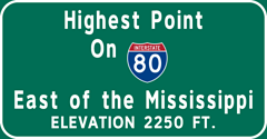
| MILE 111 |
 |
||||||||||||||||||||
| MILE 118 |
|
|
|||||||||||||||||||
| 120 | Clearfield Shawville |
||||||||||||||||||||
| Starr Hill Winery Commonwealth University-Clearfield |
|||||||||||||||||||||
Clearfield |
|||||||||||||||||||||
| Starr Hill Winery Commonwealth University-Clearfield |
|||||||||||||||||||||
| MILE 120 |
END FINES DOUBLED CORRIDOR |
SAFETY CORRIDOR
FINES DOUBLED NEXT 12 MILES |
|||||||||||||||||||
| Susquehanna River (West Branch) | |||||||||||||||||||||
| 123 | Woodland |
Woodland Shawville |
|||||||||||||||||||
| 133 | Kylertown Philipsburg |
||||||||||||||||||||
| Black Moshannon State Park | |||||||||||||||||||||
Philipsburg Kylertown |
|||||||||||||||||||||
| Clearfield County
Centre County |
|||||||||||||||||||||
| MILE 146 |
 |
||||||||||||||||||||
| MILE 146 |
 |
||||||||||||||||||||
| 147 | TO Snow Shoe |
|
|||||||||||||||||||
| 158 |
|
||||||||||||||||||||
| EXITING TRUCKS STAY IN REDUCED GEAR |
|||||||||||||||||||||
| TRUCKS TO LOCK HAVEN |
|||||||||||||||||||||
| USE EXIT 178 | |||||||||||||||||||||
|
|||||||||||||||||||||
| Bald Eagle State Park | |||||||||||||||||||||
|
|||||||||||||||||||||
| Bald Eagle State Park Black Moshannon State Park |
|||||||||||||||||||||
| 161 |
|
||||||||||||||||||||
| State College Penn State University |
|||||||||||||||||||||
|
|||||||||||||||||||||
| State College Penn State University |
|||||||||||||||||||||
| 163 | TO Jacksonville Howard |
||||||||||||||||||||
| Centre County
Clinton County |
|||||||||||||||||||||
| 173 | Lamar |
||||||||||||||||||||
| TRUCKS TO LOCK HAVEN |
|||||||||||||||||||||
| USE EXIT 178 | |||||||||||||||||||||
Lamar |
|||||||||||||||||||||
| 178 | Lock Haven |
||||||||||||||||||||
| Williamsport Commonwealth University-Lock Haven |
|||||||||||||||||||||
Lock Haven |
|||||||||||||||||||||
FOLLOW |
|||||||||||||||||||||
| Commonwealth University-Lock Haven | |||||||||||||||||||||
| 185 | Loganton |
||||||||||||||||||||
| Raymond B. Winter State Park | |||||||||||||||||||||
| MILE 189 |
|||||||||||||||||||||
| 192 | TO Jersey Shore |
||||||||||||||||||||
| TO Jersey Shore |
|||||||||||||||||||||
| MILE 193 |
 |
||||||||||||||||||||
 |
|||||||||||||||||||||
| MILE 193 |
 |
||||||||||||||||||||
 |
|||||||||||||||||||||
| MILE 194 |
|||||||||||||||||||||
| Clinton County
Union County |
|||||||||||||||||||||
| MILE 194 |
|||||||||||||||||||||
| MILE 195 |
 |
||||||||||||||||||||
| 199 | Mile Run | ||||||||||||||||||||
| NO SERVICES | |||||||||||||||||||||
| 210 A | EXPRESSWAY Marine Corps League Memorial Highway Lewisburg |
||||||||||||||||||||
| Sunbury Bucknell University |
|||||||||||||||||||||
EXPRESSWAY Marine Corps League Memorial Highway Lewisburg |
|||||||||||||||||||||
| EXIT ONLY | Bucknell University | ||||||||||||||||||||
| 210 B | EXPRESSWAY Marine Corps League Memorial Highway Williamsport |
||||||||||||||||||||
| Reptiland Zoo Little League Museum |
|||||||||||||||||||||
EXPRESSWAY Marine Corps League Memorial Highway Williamsport |
|||||||||||||||||||||
| EXIT ONLY | Reptiland Zoo Little League Museum |
||||||||||||||||||||
| Union County
Northumberland County |
|||||||||||||||||||||
|
Senator Z. H. Confair Memorial Bridge
Susquehanna River |
|||||||||||||||||||||
| 212 A | EXPRESSWAY Milton |
||||||||||||||||||||
EXPRESSWAY Milton |
|||||||||||||||||||||
| 212 B | Williamsport |
||||||||||||||||||||
Williamsport |
|||||||||||||||||||||
| 215 | Limestoneville |
||||||||||||||||||||
Limestoneville |
Milton Business District | ||||||||||||||||||||
| Northumberland County
Montour County |
|||||||||||||||||||||
| MILE 218 |
 |
||||||||||||||||||||
| MILE 219 |
 |
||||||||||||||||||||
| 224 | Danville |
||||||||||||||||||||
| Shamokin Mount Carmel Geisinger Medical Center |
|||||||||||||||||||||
Danville |
|||||||||||||||||||||
| Sunbury Geisinger Medical Center |
|||||||||||||||||||||
|
Montour County
Columbia County |
|||||||||||||||||||||
| 232 | Buckhorn |
||||||||||||||||||||
| Columbia Mall Bloomsburg Fairground |
|||||||||||||||||||||
Buckhorn |
|
||||||||||||||||||||
| Columbia Mall Bloomsburg Fairground |
|||||||||||||||||||||
| 236 A | Bloomsburg |
||||||||||||||||||||
| Commonwealth University-Bloomsburg | |||||||||||||||||||||
| 236 B | Lightstreet |
||||||||||||||||||||
| 236 | Lightstreet Bloomsburg |
||||||||||||||||||||
| Commonwealth University-Bloomsburg | |||||||||||||||||||||
| 241 A | Lime Ridge |
||||||||||||||||||||
| 241 B | Berwick |
||||||||||||||||||||
| 241 | Lime Ridge Berwick |
||||||||||||||||||||
| Susquehanna River (East Branch) | |||||||||||||||||||||
| 242 | Mifflinville Mainville |
Mainville Mifflinville |
|||||||||||||||||||
| MILE 245 |
 |
||||||||||||||||||||
 |
|||||||||||||||||||||
| MILE 246 |
 |
||||||||||||||||||||
 |
|||||||||||||||||||||
| MILE 247 |
|||||||||||||||||||||
| Columbia County
Luzerne County |
|||||||||||||||||||||
| 256 | Nescopeck Conyngham |
Conyngham Nescopeck |
|||||||||||||||||||
| Penn State University Hazleton Campus | |||||||||||||||||||||
| 260 A | American Legion Memorial Highway Harrisburg |
||||||||||||||||||||
American Legion Memorial Highway Harrisburg |
|||||||||||||||||||||
| EXIT ONLY | |||||||||||||||||||||
260 B |
NORTH American Legion Memorial Highway Wilkes - Barre |
||||||||||||||||||||
| 260 B | American Legion Memorial Highway Wilkes - Barre |
||||||||||||||||||||
| 262 | Mountain Top Hazleton |
||||||||||||||||||||
| Best Cigar Pub CAN DO Corporate Center |
|||||||||||||||||||||
| Eckley Miners Village | |||||||||||||||||||||
Mountain Top Hazleton |
Best Cigar Pub CAN DO Corporate Center |
||||||||||||||||||||
| MILE 270 |
 |
||||||||||||||||||||
| 273 |
|
|
|||||||||||||||||||
| TRUCK ALERT | |||||||||||||||||||||
|
|||||||||||||||||||||
|
|||||||||||||||||||||
| PROHIBITED
102" TWINS 102" TRAILERS OVER 28½ FEET ON PA 437 |
|||||||||||||||||||||
| Luzerne County
Lehigh River Carbon County |
|||||||||||||||||||||
| 274 | Hickory Run State Park |
||||||||||||||||||||
| MILE 274 |
 |
||||||||||||||||||||
| MILE 275 |
|||||||||||||||||||||
| 277 |
|
||||||||||||||||||||
| Lake Harmony | |||||||||||||||||||||
|
|||||||||||||||||||||
| Lake Harmony | |||||||||||||||||||||
| Carbon County
Monroe County |
|||||||||||||||||||||
| 284 | Blakeslee |
||||||||||||||||||||
| Pocono Raceway | |||||||||||||||||||||
Blakeslee |
|||||||||||||||||||||
| Wilkes - Barre Pocono Raceway Jack Frost Ski Area Big Boulder Ski Area |
|||||||||||||||||||||
| MILE 292 |
|||||||||||||||||||||
| MILE 292 |
TRUCKS
5 MILE HILL 4 ½ % GRADE |
END FINES DOUBLED CORRIDOR |
|||||||||||||||||||
| USE LOWER GEAR | |||||||||||||||||||||
293 |
NORTH Scranton |
||||||||||||||||||||
| MILE 293 |
SAFETY CORRIDOR
FINES DOUBLED NEXT 17 MILES |
||||||||||||||||||||
| 293 | Scranton |
||||||||||||||||||||
| EXIT ONLY | |||||||||||||||||||||
| MILE 295 |
 |
||||||||||||||||||||
| 298 | Scoturn |
||||||||||||||||||||
| TRUCK NORTH |
|||||||||||||||||||||
| Mount Pocono Camel Back Ski Area |
|||||||||||||||||||||
| 299 | Tannersville |
||||||||||||||||||||
| Northampton Community College Monroe Campus The Crossings Premium Outlets Mount Airy Casino Resort Camel Back Ski Area |
|||||||||||||||||||||
| Big Pocono State Park | |||||||||||||||||||||
Tannersville |
|||||||||||||||||||||
| TRUCK SOUTH |
|||||||||||||||||||||
| Northampton Community College Monroe Campus The Crossings Premium Outlets Mount Airy Casino Resort Camel Back Ski Area |
|||||||||||||||||||||
| Big Pocono State Park | |||||||||||||||||||||
| 302 A |
|
|
|||||||||||||||||||
|
Lehighton Easton |
|||||||||||||||||||||
| NO SERVICES | |||||||||||||||||||||
| 302 B |
|
||||||||||||||||||||
| American Candle Pocono Peddler's Village Antique Mall Shoppes at Crossroads Crossroads Mall of the Poconos |
|||||||||||||||||||||
| 302 |
|
||||||||||||||||||||
| American Candle Pocono Peddler's Village Antique Mall Shoppes at Crossroads Crossroads Mall of the Poconos |
|||||||||||||||||||||
| 303 | 9th Street |
||||||||||||||||||||
| Stroud Mall Shoppes at Stroud |
|||||||||||||||||||||
| MILE 304 |
|||||||||||||||||||||
| 304 |
|
||||||||||||||||||||
| Lehighton Bethlehem |
|||||||||||||||||||||
| 305 | Main Street |
||||||||||||||||||||
| 306 | Dreher Avenue | ||||||||||||||||||||
| 307 |
|
||||||||||||||||||||
| Stroudsburg Business District | |||||||||||||||||||||
Broad Street |
|||||||||||||||||||||
| Stroudsburg Business District | |||||||||||||||||||||
| 308 | East Stroudsburg | ||||||||||||||||||||
| East Stroudsburg University of Pennsylvania | |||||||||||||||||||||
| East Stroudsburg | |||||||||||||||||||||
| East Stroudsburg University of Pennsylvania | |||||||||||||||||||||
| 309 |
|
||||||||||||||||||||
|
|||||||||||||||||||||
| Shawnee Bushkill Pocono TreeVentures Ski Shawnee Bushkill Falls |
|||||||||||||||||||||
|
|||||||||||||||||||||
|
|||||||||||||||||||||
| Shawnee Bushkill Pocono TreeVentures Ski Shawnee Bushkill Falls |
|||||||||||||||||||||
| MILE 309 |
 |
||||||||||||||||||||
| 310 | TO Delaware Water Gap |
||||||||||||||||||||
Delaware Water Gap Business District |
|||||||||||||||||||||
 |
|||||||||||||||||||||
| MILE 310 |
END FINES DOUBLED CORRIDOR |
SAFETY CORRIDOR
FINES DOUBLED NEXT 18 MILES |
|||||||||||||||||||
| 310 | TO Delaware Water Gap |
||||||||||||||||||||
Delaware Water Gap Business District |
|||||||||||||||||||||
 |
|||||||||||||||||||||
| MILE 310 |
|||||||||||||||||||||
| MILE 310 |
Delaware Water Gap Toll Bridge TOLL PLAZA
|
|
|||||||||||||||||||
| COMMONWEALTH OF PENNSYLVANIA
Delaware Water Gap Toll Bridge Delaware River STATE OF NEW JERSEY |
|||||||||||||||||||||
 Exit Guide