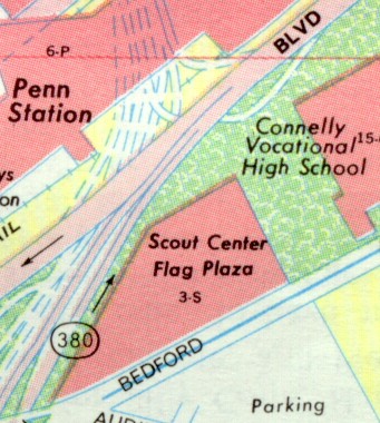
Crosstown Boulevard
Crosstown
Boulevard
Constructed in the early 1960s at that time when Renaissance I was underway in the Golden Triangle, Interstate 579 was originally conceived by Robert Moses. The man known for improving New York City's transportation infrastructure, devised a plan for Pittsburgh in 1939 that included the revitalization of the area at the Point, the Penn-Lincoln Parkway, and the Crosstown Boulevard.
 Drawing of the proposed interchange between the Pitt Parkway and Crosstown Boulevard. (Arterial Plan for Pittsburgh) |
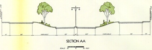 Cross section of what the Crosstown Boulevard would have looked like. (Arterial Plan for Pittsburgh) |
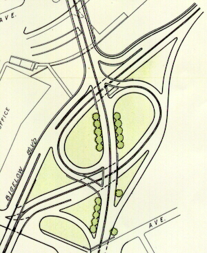 Drawing of the proposed interchange between the Crosstown Boulevard and Bigelow Boulevard. (Arterial Plan for Pittsburgh) |
On February 23, 1950, Allegheny County Commissioners announced they were ready to meet with city officials and civic groups in planning for the highway which would start at the Liberty Bridge and extend to Grant Street at the end of Bigelow Boulevard. A week prior, city and county officials had received a letter from E. L. Schmidt, Chief Engineer for the Department of Highways, asking the two groups to come together and get started on final plans for the expressway immediately. Schmidt said the state accepted responsibility for building an interchange between the Crosstown Boulevard, Liberty Bridge, Boulevard of the Allies, and Penn-Lincoln Parkway, which would extend as far as Forbes Avenue.
County officials balked on coming to an agreement with city officials on the Crosstown project on April 26, 1950. They visited City Council Chambers at the request of Mayor David L. Lawrence to discuss the expressway. The Mayor was convinced that the City and County were in agreement on the proposed six-lane highway which would cut across the Golden Triangle. This belief was indicated when the Mayor brushed aside discussion and addressed the main concern: "Who is going to pay and how much?" John J. Kane, chairman of the Board of County Commissioners, shied away from the direct approach to discussing the division of expenses between the City and County.
There were differing opinions over where the expressway would be routed, which Kane cited as the problem that had not been ironed out. He said, "There always has been a difference of opinion between the two governments on the Crosstown Thoroughfare. At the present time this Board (of Commissioners) is not in full agreement." He suggested that the expressway be split, routing the northbound lanes on Tunnel Street and the southbound on Chatham Street. This would provide two lanes each way, producing a bottleneck if the remainder of the expressway was six-lanes some planners say. The plan was never considered by the two Planning Commissions. Kane's attitude summoned a quick reply from City officials, with the Mayor saying he understood the City and County Planning Commissions "have agreed on the alignment and number of lanes (six) from the southerly side of Forbes to Webster." Thomas E. Kilgallen, president of the council, asked "Are there any differences between the City and the County?" Frederick Bigger, chairman of the City Planning Commission replied, "None." Thomas H. Hester, Director of the County Planning Commission replied to a question from the Mayor by saying, "Our Commission has not officially approved the six-lane road but it likely will."
After the hearing, it was pointed out that there had been a long delay in reaching a decision as the City Planning Commission had given its approval on March 1, 1949. Later in the meeting, Hester said, "I don't know what the attitude will be." The two governments argued sharply over whether the project would be a City or County project. Councilman Kilgallen said, "We have always considered this a County project." Commissioner Harry W. Fowler retorted with, "This is a City proposition." Mayor Lawrence said 60% of the traffic coming into the city over the Liberty Bridge originates outside the City limits; therefore, it should be a County project.
Commissioner Kane argued that the City's financial condition is better than when the County assumed the majority of the cost of the Water Street improvement, the Duquesne Way pavement, and the Seventh Avenue Bridge separation. Kane also said that the City had three new sources of revenue through taxes implemented, while he was faced with providing money to all communities throughout the County. The meeting was halted and would resume on May 4 to consider the plan. Mayor Lawrence said he stopped the meeting after receiving a letter from the Chief State Highways engineer, stating that the expressway "would be absolutely necessary for the free movement of traffic to and from the East on the Penn-Lincoln Parkway and...in the downtown area."
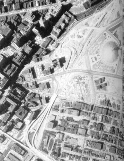
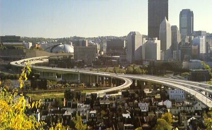
Aerial picture of the progress on the Crosstown Boulevard
in 1963. (American Air Surveys, Inc.)
On June 21, 1950, the Allegheny County Commissioners agreed to pay for almost half of the cost of the expressway: $2,500,000. City Works Director James S. Devlin estimated that the 82-foot-wide, six-lane expressway would cost $5,271,500. The agreement came at a meeting of the commissioners, Mayor David L. Lawrence, and City Councilmen John T. Duff Jr. and Thomas G. Gallagher. The Mayor said that "the rest of the councilmen were needed in the next room on important business," but Duff and Gallagher were authorized to make the agreement. The city and county planning commissions had agreed on the expressway plan which had been approved formally by city council, the mayor, and the county commissioners. Devlin estimated that it would take from a year to 15 months to get "working plans" and that construction would start on the project in about two years. The plan still needed to be approved by the Department of Highways under the county-aid law and because it would connect with the Penn-Lincoln Parkway near Forbes Street. Officials indicated they intended to hire George S. Richardson, a well-known consulting engineer, to complete the final plans for the construction. Richardson already had a hand in a Pittsburgh expressway when he was a state consultant on the Penn-Lincoln Parkway.
Seemed talk was what was accomplished more than actual work on the Crosstown Boulevard. That was the case until August 7, 1950, when an ordnance was introduced in City Council establishing the right-of-way for the six-lane, partially elevated and partially below grade $5,300,000 expressway. Director James S. Devlin of the Pittsburgh Department of Public Works explained that there would be an unrestricted flow of traffic from the South Hills to Webster and Seventh Avenues. He also predicted that construction would begin before 1953, and take a year and a half to build. Estimated amount of property that would be acquired totaled $1,300,000. Although no large buildings would be acquired, several shops, drug stores, and a gas station would be demolished, and a corner of the Number Three Engine House would be sheared off and rebuilt.
On February 26, 1957, it was announced that the embattled project would be placed on the primary, urban, or Interstate System. In a letter from Joseph J. Lawler, State Highways Secretary to then Mayor David L. Lawrence said he would recommend the addition, which meant that the entire project estimated then at $42 million, would be built without the City of Pittsburgh or Allegheny County anteing up a cent. The only cost the city would have to pay would be connecting streets to the expressway. Without the commitment of the state to aid in paying for construction, the expressway would have ended at Seventh Street. The total cost of Forbes Street to Webster and Seventh Avenues was estimated at nearly $5,250,000.
On August 10, 1960, the City Planning Commission struck down the Department of Highways' because they felt that the state did not address traffic problems in the downtown core when designing the Crosstown Boulevard. This was a moot point as construction had already begun on the expressway. When asked by the state to comment on the design, the commission said it saw little reason to comment on plans already approved. The Commission charged that the expressway had been "over-designed" to Interstate Standards, although it was not to be an Interstate highway at the beginning. Another problem with the expressway was that it was only 50% Federally funded, which was 40% less than how other Interstates were funded. Other objections with the expressway were:
The planners said, "It would appear to us that the scale of construction and the capacity of traffic volume being planned for this project are out of character with the needs of the central business district." They also said that the $45 million price tag for the expressway was higher than it should be, but they added, "The State is not concerned with the city traffic pattern."
The first section to be built was from the Boulevard of the Allies, also known as PA 885, to Centre Avenue. This opened to traffic in 1962 and the section from Centre to Bigelow Boulevard, also known as PA 380, opened in 1964. For the next two decades, this would be the only open section of the Crosstown Boulevard. The long range plans called for a connection from the end at Bigelow Boulevard to the proposed I-79 on the North Side, but would remain shelved until the 1980s.
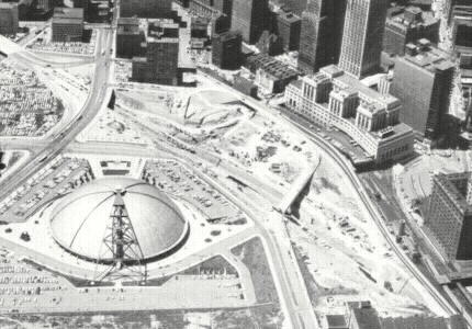
Crosstown Boulevard under construction in 1964.
(American Air Surveys,
Inc.)
Opponents of this and Interstate 279 through the North Hills always said, "It will be a cold day in hell when ground is broken for this highway." Well, they were close, as Governor Richard Thornburgh, county, city, and local officials weathered below-freezing temperatures, below zero wind chill, and a blowing snowstorm to break ground for the $45 million extension of the Crosstown Boulevard on March 8, 1984. The Governor pointed to the stub ends of ramps built near the Civic Arena in the 1950s and said, "We learned that sometimes dreams outrace our means. We're now going to finish this highway system that was planned several decades ago."
This is a shot from the North Side looking onto
the city.
The
ramp from the left is going to PA 28 North
and the others are
to/from I-279. The center ramp are the HOV
lanes.
(Joel B. Levinson)
Cameron Construction Company of the North Side built the Veterans Bridge at a cost of $15.9 million, and Ruhlin Construction Company of Akron, Ohio built the highway connecting from the end at Bigelow Boulevard to the bridge. The work involved building 50 piers to carry the ramps 30 feet above the Strip District, Norfolk-Southern tracks, Amtrak passenger station, the Martin Luther King Jr./East Busway, and the PATransit light rail line. The Veterans Bridge opened on, appropriately enough, Veterans Day, November 11, 1989, along with the section from Bigelow Boulevard to the I-279 interchange when Interstate 279 was finally completed. The opening ceremonies included a National Guard artillery firing ceremoniously from the bridge deck.
The Veterans Bridge is the only bridge of
its type in the Pittsburgh area.
Two planned interchanges were not built: Fort Duquesne Boulevard and Bigelow Boulevard/PA 380 east from the southbound Crosstown Boulevard. Rand McNally used to indicate the proposed ramps on their early 1980s maps of Pittsburgh.
|
|
|
|
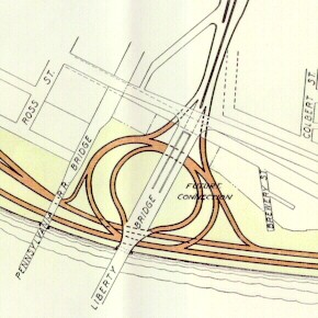
I have only seen the Fort Duquesne Boulevard ramps indicated on a Gousha map of Pittsburgh from 1991.
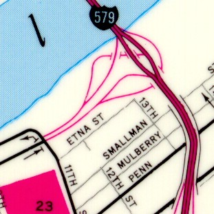
Fort Duquesne Boulevard ramps shown as
completed on a 1991 Gousha map of Pittsburgh.
(H. M. Gousha)
Pittsburgh welcomed the world in 2009 when President Barack Obama hosted the G-20 Summit at the David L. Lawrence Convention Center from September 24 to September 25. Due to the heightened security in the Golden Triangle, ramps to and from Interstate 579 were closed to all traffic except for emergencies.
A bridge preservation project began in early 2010 along the expressway and was split into two phases. The $18 million Phase I portion focused on the expressway portion and was completed in late 2012. Phase II included improvements on the Veterans Bridge which began in late March 2012 and finished in Fall 2013 at a cost of $17 million. The entire project encompassed preservation work on twenty existing bridge structures and one retaining wall including structural painting, deck repairs, latex overlays, concrete substructure repairs, bearing replacements, installation of neoprene strip seal dams, drainage system repairs, pin and hanger retrofits, bituminous pavement, highway lighting, signing and pavement marking, ITS work and sign structure, and other improvements.
Plans to cover the expressway near the former site of the Civic Arena had been discussed but it wasn't until June 2019 that the plans started to turn into reality. On the 14th, ground was broken in the PPG Arena West Lot on the I-579 Cap Urban Connector Project. "The Cap will be transformative by removing a physical barrier and re-establishing connectivity to centers of employment, education, and services in Downtown," states the Pittsburgh Sports & Exhibition Authority. The project began at the end of June will cost an estimated $32 million funded in part by the state as well as a $19 million grant from the US Department of Transportation. The Cap encompasses Washington Place, Centre Avenue, Chatham Street, Bigelow Boulevard, and other surrounding areas and features accessible walkways, bike lanes, murals from local artists, lower ambient temperatures and rain gardens for storm water management. The cap was officially completed on November 22, 2021 when local and state dignitaries including Governor Tom Wolf cut the ribbon signifying its opening. The $29 million project bares the name Frankie Pace Park after a Hill District advocate who was born in 1905.
On July 15, 2022, the Pennsylvania Department of Transportation announced that it was the recipient of a regional America's Transportation Award from the American Association of State Highway and Transportation Officials (AASHTO) for the cap project in the "Quality of Life/Community Development" category. "The I-579 Cap is a great example of a project that aims to right the wrongs of the past through innovative, sustainable and smart transportation," said PennDOT Secretary Yassmin Gramian. "I am proud that AASHTO has recognized our efforts."
PennDOT was the recipient of a regional America's Transportation Award from @aashtospeaks. We were recognized for reconnecting #Pittsburgh communities through the I-579 Cap Project: https://t.co/MuQ0nM9DJ4@PennsylvaniaGov @511PAPittsburgh #PAProud pic.twitter.com/seGtJsFWs8
— PA Department of Transportation (@PennDOTNews) July 19, 2022
When the Coronavirus, or COVID-19, pandemic swept into the country in March 2020, PennDOT took measures to stem the spread to their employees and staff. All rest areas and welcome centers and Driver License and Photo License centers were closed for two weeks, and construction projects on roads under the Department of Transportation's jurisdiction were stopped as of Tuesday, March 17. PennDOT District 11 decided to indefinitely close the HOV lanes for public safety purposes as well. District Spokesman Steve Cowan said it was necessary as staff were working and have limited access to all of the normal traffic cameras. "We won't have the compliment of maintenance personnel on the ground to keep the HOV lanes open to the level of safeness that we are comfortable with. Additionally, we are anticipating much lower traffic volumes." The closure was to have begun at 5 AM on March 17, but District 11 decided to keep them closed after a fatal accident took place Monday evening. The lanes reopened to northbound traffic on May 21, 2021. Studies showed that more traffic was moving in that direction versus southbound at the time, but that a move back to bi-directional usage would be eventually taken once it was warranted. The HOV lanes reopened to inbound traffic for the morning commute on August 4, 2021.
Protests over the death of George Floyd, a Minneapolis, Minnesota man who died in police custody when an officer knelt on his neck on May 25, 2020, started in Pittsburgh on May 30. Marchers started towards the Liberty Bridge around 4 PM, but we met by a Pennsylvania State Police barricade at Sixth Street. Meanwhile, protesters did manage to bring traffic to a standstill on the Veterans Bridge around 6 PM. One motorist managed to drive through the crowd gathered on the ramp to PA 28 northbound, and fortunately, no one was killed or injured.
At one time, Interstate 579 was the shortest Interstate in the country.
Links:
Exit Guide
Interstate 579 Ends
Interstate 579 Pictures
Interstate 479
(Decommissioned)
Interstate 876
(Decommissioned)
North Hills Busway/North Hills Expressway HOV Lanes
The Bigelow Boulevard/Crosstown Expressway (Interstate 579) Ghost Ramp
Mystery Explained - Adam Prince
HOV
Lanes - PennDOT
Interstate 579 - Andy Field/Alex Nitzman
Interstate 579 - Scott Oglesby
Interstate
579 Pictures - Andy Field/Alex Nitzman
Interstate
579 Pictures - Steve Alpert
Veterans
Bridge - Bruce Cridlebaugh
 INFORMATION
 |
| Southern Terminus: | PA 885 and SR 3069 in Pittsburgh |
| Northern Terminus: | I-279 at Exit 2A in Pittsburgh |
| Length: | 1.77 miles |
| National Highway System: | Entire length |
| Name: | Crosstown Boulevard |
| SR Designations: | 0579 6579: HOV lane |
HOV Lane: |
Operate in the median
of the Interstate from Bedford Avenue to I-279. Open to cars, trucks,
and vans with two or more occupants and all motorcycles Monday through Friday. Inbound: 6 AM - 9 AM Outbound: 4 PM - 7 PM Open to all vehicles outbound 7 PM Friday to 5 AM Monday. |
| County: | Allegheny |
| Multiplexed Routes: | None |
| Former Designations: | I-479 (1966 - 1971) I-876 (1971 - 1972) |
| Former LR Designation: | 1026: PA 885 to PA 380 |
| Emergency: | 911 |
 Traffic Cameras: |
HOV-Bedford Avenue HOV-Veterans Memorial Bridge |