One of the two main routes that connected the Philadelphia, Allentown-Bethlehem, and Wilkes-Barre/Scranton areas before the Pennsylvania Turnpike's Northeast Extension opened, US 309 was the predecessor of PA 309.
Signed in 1928, the route began in Philadelphia at an intersection with US 611 then followed Haines Street, Wyncote Avenue, Stenton Avenue and Bethlehem Pike to enter Montgomery County and followed the current PA 309 north to Allentown. In Allentown, the route followed Fourth Street, Susquehanna Street, Fifth Street, Lehigh Street, Union Street, Eighth Street, Hamilton Street, 17th Street, Tilghman Street, 19th Street, and Walbert Avenue. At its northern end in Wilkes-Barre, it followed Hazel Avenue, Park Avenue, and South Street to end at US 11 on River Street.
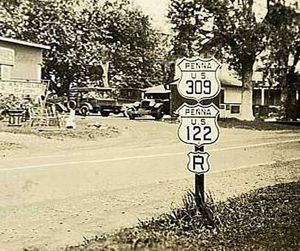 |
| US 309, US 122, and Right Turn markers on an assembly within the multiplex of the two routes on Bethlehem Pike in Montgomery County. (Unknown) |
The same year it was first signed in the state, it was under construction from Quakertown to Center Valley and Hazleton to the Saint John's Road/Honey Hole Road intersection in Luzerne County. Work on the former section finished a year later, but the work on the latter section would not finish until 1930.
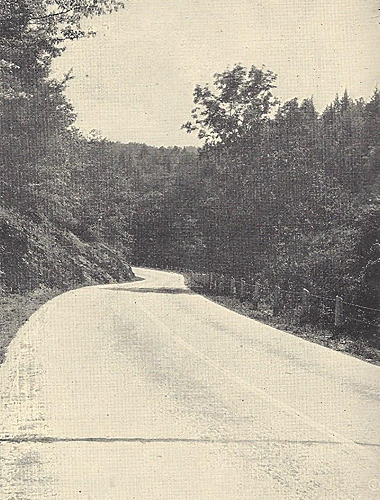 |
| US 309 south of Weissport in Carbon County in 1929. (Pennsylvania Department of Highways) |
Changes at both ends of the route kicked off the 1930s, with US 309 removed from Haines Street and the southern terminus moved south on US 611 to the intersection with Stenton Avenue. At the northern end, the change moved the terminus a much greater distance than happened in Philadelphia. The route was extended to the New York state line via River Street, River Road, Main Street, and Plank Street in Pittston. From there, it crossed the Susquehanna River's East Branch into West Pittston to follow the current PA 92 alignment to US 6, which was then signed on what is now PA 307. US 309 was then multiplexed with US 6 to US 220 in Towanda and then multiplexed with the latter to the New York state line. In Tunkhanock, it followed Tioga Street and in Towanda it followed Main Street and York Avenue. Through Athens and Sayre, US 309 followed Main Street, Keystone Avenue, and North Pennsylvania Avenue to its new northern terminus at the state line in South Waverly.
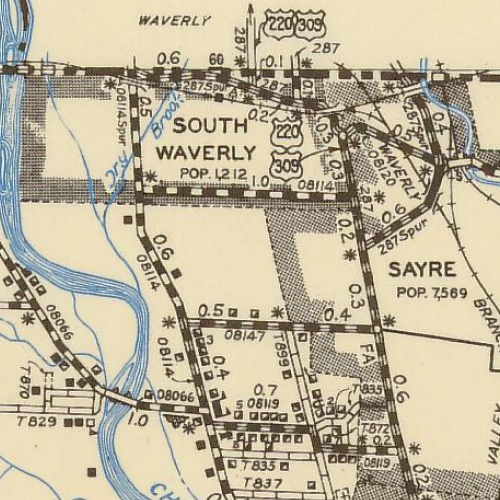 |
| The route of US 309 through South Waverly where its northern terminus was moved to in 1930. (Pennsylvania Department of Highways) |
Not only did the location of US 309's ends change in 1930, but also the path of the route through Allentown was modified. The first change was the route was placed on Auburn Street between South Fifth Street and Lehigh Street. After crossing the Little Lehigh Creek, the route was moved from South Sixth Street to the west on to South Seventh Street, where it intersected Hamilton Street at the Lehigh County Soldiers and Sailors Monument. Yet another change at the southern end of the route took place in 1931 when US 309 was removed from Stenton Avenue and placed on Bethlehem Pike and Germantown Avenue to end at the intersection of the latter and US 611/North Broad Street in North Philadelphia. Even more changes to the route took place in 1932 in Wilkes-Barre and again in Allentown, just two years after the last round of changes. In the latter, the designation was extended north on to North Seventh Street and Tilghman Street to eliminate the zigzag path US 309 previously took between Hamilton Street and North 19th Street. Meanwhile, in the former, the route was moved onto Washington Street, Butler Street, Main Street, and Courtright Avenue between South Street and North River Avenue.
The first new piece of alignment to be built started in 1933 between Camp Meeting Road just north of Center Valley and Rock Road just north of present Interstate 78, which opened a year later and caused the designation to be removed from Lanark Road. Also in 1934, construction was taking place between PA 73 and PA 63 as well as Montgomeryville and Line Lexington. Both projects finished in 1935, which is also the same year yet another change to the route would take place in Philadelphia. The route was moved onto West Allens Lane and Lincoln Drive to its new southern terminus at the junction of By-Pass US 1/By-Pass US 13 and US 422 at Kelly Drive in the East Falls neighborhood of Philadelphia. The last change to take place in the 1930s to the route was when it was widened to four lanes between Philadelphia and Whitemarsh and three lanes (one lane in each direction and a middle passing lane for both directions, referred to as a "suicide lane") from there to Allentown in 1939.
Work continued on upgrading the highway in the 1940s, especially the first year of that decade which saw widening work take place from Lehighton to Packerton, Mountain Top to Solomon Gap, Ashley to Wilkes-Barre, Wilkes-Barre to Hilldale, Port Griffith to Pittston, PA 92 to Tunkhannock, and Athens to Sayre. The following year work would take place from the East Penn Township line to Bowmanstown, Kirby Avenue to Mountain Top, and Mile Road to Dark Hollow Road in Wyoming County. Improvements would be put on hold for the duration of World War II, but once it concluded, improvement work would start back up. Although, the first change to take place would not involve construction of any type when, in 1946, the route was changed between Ashley and Tunkhannock. The new route would follow Spring Street, Kidder Street, Butler Street, River Street, and Pierce Street before crossing the east branch of the Susquehanna River into Kingston. In that borough, the designation now followed Wyoming Avenue and Union Street. From that point north, US 309 and PA 92 basically swapped alignments as the new US 309 path was formerly PA 92 and PA 92 took over the former US 309 alignment between Pittston and Tunkhannock. Widening work would continue at the end of the 1940s, with Trucksville to Dallas done in 1948 and within the borough of Beaver Meadows and Russel Hill to Allen Street just south of Meshoppen done in 1949.
The 1950s ushered in more dynamic changes to the route, albeit, not initially. Widening work took place in 1952 between Blackman Street and East Northampton Street in Wilkes-Barre. On July 15, 1953, the Department of Highways petitioned the American Association of State Highway Officials (AASHO) to change the route of US 309 between Allentown and Hazleton and basically swapping it with PA 29 between the two locations. Reasons for the change were the combined mileage of three and four-lane roadways for the new route was 22.5 miles, no grades greater than 8%, and no right angle turns, compared to 6.8 miles of three and four lane roadway, 14,370 feet of grades exceeding 8%, and six right angle turns. Even after a mishap with the paperwork at AASHO's headquarters, the petition made it to the US Route Numbering Subcommittee, who approved the change along with the Executive Committee by letter ballot in mid-December 1953. The following year, US 309 was moved off Tilghman Street and instead changed to continue north on North Seventh Street to the newly-opened Allentown-Easton By-Pass, now known as the Lehigh Valley Thruway, where it became multiplexed with US 22 and followed it westward to Tilghman Street, then replaced PA 100 north to Pleasant Corner and supplanted PA 29 to Hazleton. Meanwhile, PA 29 took over the former route through Palmerton, Lehighton, and Jim Thorpe.
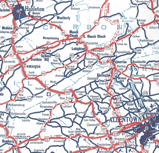 |
| The new route of US 309 between Allentown and Hazleton in 1954. (Pennsylvania Department of Highways) |
Besides that change, in 1954 widening work took place between PA 143 and one mile north of the Mosserville Road/Mountain Road in Lehigh County and Solomon Gap to Ashley in Luzerne County. Yet another change to the route took place in Philadelphia when the southern terminus was moved back to US 611/North Broad Street at its intersection with Stenton Avenue, and the route followed it to East Willow Grove Avenue then turned south to Germantown Avenue.
Widening work would continue in the mid-1950s, with the section between PA 443 and South Tamaqua and Hazleton to Kirby Avenue in Mountain Top being completed in 1955 and a year later the section between Dallas and the Wyoming County line finished. However, the big project to happen in 1956 was construction starting on its first section of limited-access alignment in the Fort Washington Expressway between the Pennsylvania Turnpike and Bethlehem Pike just north of Spring House.
Construction was the order of the business for US 309 in 1958. Work began on the section of Fort Washington Expressway between the Ogontz Avenue/Easton Road intersection and the Pennsylvania Turnpike, as well as the expressway between Lanark and the Lehigh Valley Thruway west of Allentown began that year. In addition, another segment of US 22 expressway would start, this time between Tilghman Street and the PA 100 interchange. Numerous sections of the route would see opposing directions of travel separated by a median such as Mill Drive to South Tamaqua in Schuylkill County, Hometown to McAdoo, Audenreid to Hazleton, Hazleton to West Foothills Drive, Butler Drive intersection, Saint John's Road intersection, North Old Turnpike Road to South Main Road, Church Road intersection, Mountain Top to Ashley, and just before Prevost Road to just after Stanek Road in Wyoming County. That same year, the intersection with East Northampton Street in Wilkes-Barre was made into a grade-separated junction, with traffic then utilizing ramps to and from that street as well as Casey Avenue and New Street. Widening work also took place on Main Street and York Avenue between Means Street and Chestnut Street in Towanda.
The final year of the 1950s saw some of that new expressway mileage open to traffic. In the southeastern corner of the state, the first segment of the Fort Washington Expressway opened from the PA 73 interchange to its northern end at the interchange with Bethlehem Pike north of Spring House. The new alignment between Lanark and the Lehigh Valley Thruway, as well as the section of the upgraded William Penn Highway between the former end of the Thruway at Tilghman Street and the PA 100 interchange, opened at a cost of $7 million. Those additions meant the removal of US 309 from South Fourth Street, South Fifth Street, Auburn Street, Lehigh Street, Union Street, South Seventh Street, North Seventh Street, and the Lehigh Valley Thruway between that street and the new cloverleaf on the western end of Allentown.
The 1960s would continue to see improvements taking place to US 309, but also see its demise. In 1960, the remainder of the Fort Washington Expressway from Easton Road to the PA 73 interchange opened to traffic, and with that, a new, and final, change in the routing in Philadelphia occurred. The year prior, the Department of Highways applied to the American Association of State Highway Officials to move the designation onto the new alignment. Aside from the new expressway facility, the agency citied three "severe" turns that would be eliminated. The new route would keep the southern terminus at the intersection of Stenton Avenue and US 611/North Broad Street then turn onto Ogontz Avenue which it would follow all the way to the new roadway, which meant the route was removed from the remainder of Stenton Avenue to East Willow Grove Avenue, Germantown Avenue, and Bethlehem Pike.
Yet another change in the route between Allentown and Hazleton took place in 1962, undoing some of the change that occurred a decade earlier. The Department of Highways submitted an application to AASHO on February 7, 1962, to request moving US 309 back to its original path from Walburt to Schnecksville and then over to Pleasant Corners. Several reasons were given for the move, such as shaving a little more than one and one-quarter miles off from the previous route, less adverse grades compared to the other path, and eliminating signing US 309 at two consecutive interchanges on Interstate 78. AASHO's US Route Numbering Committee approved the application on May 15, followed by their Executive Committee on June 19, with the change on the roads taking place that year.
The American Association of State Highway Officials would get more paperwork from the Department of Highways the following year when, on April 17, 1963, they submitted an application to eliminate US 309 north of Tunkhannock. Reasons given for the decommissioning were eliminating confusion for motorists as there would no longer be a US 6/US 309 nor US 220/US 309 multiplex north of Tunkhannock, and US 309 ended at the New York state line, which meant it was entirely an intrastate route. The US Route Numbering Committee approved the application on May 17, with AASHO's Executive Committee following suit on June 19. Work to remove US 309's markers along US 6 and US 220 would be completed well before the end of the year. Aside from a cosmetic change, a physical one also took place in 1963 when the roadway was widened and a median installed between Reservoir Road in Bucks County and the Lehigh County line.
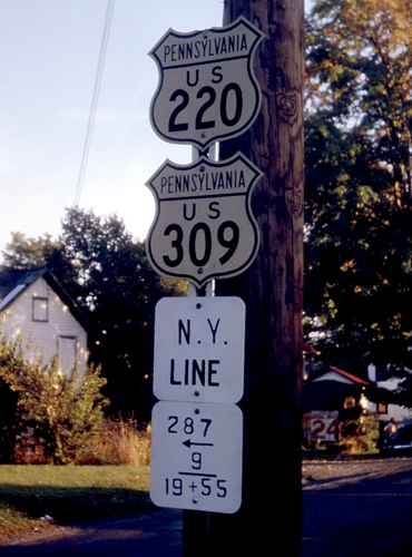 |
| US 220 and US 309 markers at the New York state line in 1961. (Jim Lindsay) |
Medians would appear on more sections of US 309 the following year, from the end of the Fort Washington Expressway to Stump Road, Rich Hill Road to Reservoir Road in Bucks County, Bucks County line to Coopersburg, and Luzerne to Dallas. In 1966, a median was installed between Colmar and County Line Road north of Unionville where the then future Sellersville Bypass would begin. Construction would begin on that $8.7 million expressway in 1967 from the Lawn Avenue interchange to its northern terminus at Rich Hill Road outside Rich Hill.
Sadly, US 309 would not be around to be signed on that new piece of roadway as the Department of Highways submitted its final piece of paperwork to the American Association of State Highway Officials to alter the route on August 23 of that year, which requested eliminating the US 309 designation and replacing it with PA 309. They cited the route being completely within the Commonwealth as the reason for the request, which in addition to being less than 300 miles in length, violated a policy that was established by AASHO effective January 1, 1959, which stated that any US route less than 300 miles in length and/or within one state should be eliminated. The US Route Number Subcommittee approved the application on September 8 and the Executive Committee did the same on October 14. Even though the route was officially decommissioned in 1967, the Department of Highways officially announced its demise on February 3, 1968. Depending on weather, the department said maintenance workers would begin erecting new PA 309 markers around the middle of the month, with several hundred needing replaced along the route, and work would be complete by the end of February. The official state road map, which would be released in March, would be the first to show the change from US 309 to PA 309.
|
| Southern Terminus: | US 611/North Broad Street in Philadelphia |
| Northern Terminus: | US 6/East Tioga Street in Tunkhannock |
| Length: | 148.69 miles |
| Names: | Stenton Avenue, Ogontz Avenue, Fort Washington Expressway, Joseph W. Hunter Highway, Bethlehem Pike, South Main Street, North Main Street, South West End Boulevard, North West End Boulevard, South Third Street, North Third Street, Route 309, West Penn Pike, Center Street, Pine Street (northbound), North Railroad Street (southbound), Claremont Avenue, Mile Hill Road, South Kennedy Drive, North Kennedy Drive, South Church Street, North Church Street, South Hunter Highway, North Hunter Highway, South Mountain Boulevard, North Mountain Boulevard, Ashley Bypass, Scott Street, Spring Street, Kidder Street, Butler Street, Courtright Avenue, North River Street, North Worth Street, Pierce Street, Wyoming Avenue, West Union Street, Union Street, Main Street, South Memorial Highway, North Memorial Highway, Tunkhannock Highway, Hunter Highway, and Bridge Street |
| LR Designations: | 67017: US 611 to Ogontz Avenue 373: Cheltenham Avenue to Easton Road interchange 782: Easton Road interchange to Norristown Road interchange 762: Norristown Road interchange to Bethlehem Pike interchange 153: Fort Washington Expressway interchange to Summit Lawn 781: Summit Lawn to Tilghman Street interchange 39043: Tilghman Street interchange to Walbert Avenue/Church Street 163: Walbert Avenue/Church Street to PA 873 226: PA 873 to US 209 in Tamaqua 185: US 209 to PA 29 in Hazleton 185 Parallel: Pine Street to US 209 in Tamaqua (southbound) 170: PA 29 to Kidder Street in Wilkes-Barre 169: Spring Street to North River Street in Wilkes-Barre 5 Spur: Courtright Avenue to West North Street in Wilkes-Barre 40116: North River Street to US 11 in Kingston 11: Pierce Street to West Union Street in Kingston and Main Street interchange to US 6 in Tunkhannock 40105: US 11 to the Main Street interchange in Luzerne |
| Counties: | Philadelphia, Montgomery, Bucks, Lehigh, Schuylkill, Carbon, Luzerne, and Wyoming |
| Multiplexed Routes: | US 202: Montgomery Square to Montgomeryville PA 443: PA 443 to South Tamaqua US 11: Pierce Street to Union Street in Kingston |
| Expressway: | Old Mill Road in Wyncote to Bethlehem Pike in Lower Gwynedd Township, Montgomery County South Fourth Street in Summit Lawn to Ridgeview Drive in South Whitehall Township, Lehigh County |
| Former Designations: |
PA 12 (1927 - 1928): Philadelphia to Center Valley PA 52 (1927 - 1928): DeKalb Pike to Montgomeryville PA 92 (1927 - 1928): Center Valley to Allentown PA 22 (1927 - 1928): Allentown to Wilkes-Barre PA 15 (1927 - 1928): Wilkes-Barre to Trucksville PA 19 (1927 - 1928): Kingston to Luzerne PA 62 (1927 - 1928): Trucksville to Tunkhannock PA 92 (1928 - 1946): US 11 to Tunkhannock PA 29 (1928 - 1954): Schnecksville to Hazleton PA 152 (1928 - 1960): Stenton Avenue to South Easton Road in Philadelphia |
| Decommissioned: | 1968 |
| Replaced By: | PA 309 |
| Links: | Fort Washington Expressway US 309 Auxiliary Routes PA 309 End of Historic US 309 - Dale Sanderson Fort Washington Expressway - Steve Anderson Old US 309, Bethlehem Pike - Steve Alpert |
 Joseph W. Hunter Highway
 INFORMATION