Fallen Trooper Memorial Highway
Fallen Trooper Memorial Highway
Originally, this Interstate was to traverse extreme northern Pennsylvania from Erie to Scranton along the US 6 alignment when the initial Interstate routings were published on August 14, 1957. On June 27, 1958, the Bureau of Public Roads changed the route of the Interstate because of a change in the routing of Interstate 80 across the Commonwealth.
The 1964 Department of Highways map was the first time the public would see the path of future Interstate 84. Its gray, dashed line stretching from Interstate 81 in Moosic to the New York state line over the Delaware River in Matamoras. The Department of Highways would start changing that gray dashed line into a green dashed line as construction began in Pike County between Spring Road west of Lords Valley to Sawkill Road in 1967. The following year, construction was extended westward to Beaver Dam Road just east of PA 507 and eastward to Palmer Road northeast of Milford.
With progress taking place in Pike County, news was just as good in Lackawanna on future work. State Highways Secretary Robert G. Bartlett was notified on April 15, 1969 and confirmed the following day that the US Department of Transportation had chosen the so-called "northern route" over two other proposals to link Interstate 81 to Interstate 81E over the Moosic Mountains. The one proposal called for a connection near the Elmhurst Reservoir and the other for a connection at Moosic. The Department of Highways had advocated for the northern route, with state highways officials feeling that alignment would "serve the most people and injure the fewest." Thomas Harrington, Scranton District engineer for the Department of Highways was also pleased with the decision.
 |
 |
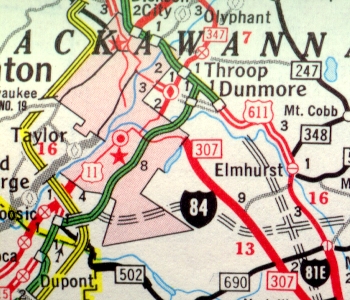
| Proposed routing
of Interstate 84 west of the current Interstate 380 alignment as indicated
in 1967. (Pennsylvania Department of Highways) |
|
The US Department of Transportation decision was made even with protests by a number of local groups such as the Greater Wilkes-Barre Chamber of Commerce, with the support of US Representative Daniel Flood, which demanded the connection be made at Moosic. According to federal officials, the Moosic connection would cost far more than the $18.7 million estimate for construction of the connection near Elmhurst. It was estimated that construction of the proposed link had been delayed by about two years due to the Luzerne County protests against the northern route plan. The plan for a connection near the Elmhurst Reservoir was cancelled with respect to the Pennsylvania Water & Gas Company which warned that the project could pollute the reservoir.
Construction continued in 1969 as work was extended eastward to the first exit inside New York and westward to just west of the PA 191 interchange.
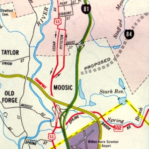
The first section of Interstate 84 to open would be the bridge spanning the Delaware River in 1970, while it would be two more years until a section of Interstate on land would open. In 1972, the section from Exit 26 to Exit 53 opened to traffic. That same year, it was determined that the Moosic Mountains would prove to be an engineering challenge, and require an alteration in the proposed alignment. The Department of Highways moved the western terminus north on Interstate 81 to its current location, creating a multiplex with the new Interstate 380 which was signed to replace Interstate 81E. Construction on an Interstate-grade highway had begun in 1960 and finished in 1961 between Interstate 81 and Tigue Street.
In 1973, work was extended west for a second time to Aberdeen Road southwest of Drinker. Also in that year, the section from Exit 1 to Exit 2 was upgraded to Interstate standards. In 1974, work was extended westward a third time to Exit 8 while another section opened to traffic from Exit 17 to Exit 26. Construction began on the massive Directional T interchange between Interstate 84 and Interstate 380 in 1975, which also included a section to the PA 435 overpass. In 1976, the section between Exit 8 and Exit 17 opened while construction began on the section from the PA 435 overpass to Exit 8.
As the Interstate opened piece by piece, PennDOT decided to mark the exits using mileage-based exit numbers beginning in 1975. A mere two years later, they were switched to sequential numbering. Mileage-based exit numbers would reappear on Interstate 84 in 2001.
Finally, the last section to open between Interstate 380 and Exit 8 occurred in 1978.
During the 1990s, most of Interstate 84 was rebuilt with the last part the interchange at Interstate 81. This was occurring as the Lackawanna Valley Industrial Highway, now known as the Robert P. Casey Highway, was being connected at the same interchange. This massive newly-reconfigured interchange opened in October 1999.
We all know why the chicken crossed the road, and it seems at least 250 of them knew as well on the morning of September 6, 2012. State Police and PennDOT were sent out to a section in Dunmore after receiving calls from drivers who spotted chickens running free and more than a dozen crates filled with chickens on the side of the Interstate. No one knows how the chickens got there, but it was more than likely a truck hauling chickens that somehow lost its load without the driver knowing. The Interstate was not closed because the chickens were resting off to the side of the travel lanes. PennDOT workers gathered and delivered them to the Griffin Animal Pond Shelter.
A major rebuilding project began on October 29, 2013 between Exit 46 and the New York state line. Initial work entailed building crossovers to move traffic from the westbound lanes to the eastbound lanes and in Spring 2014, the rehabilitating work will begin. The project will include replacing the eastbound and westbound lanes, rehabilitating seven bridges, building a new bridge, rehabilitating five culverts, retaining wall, sanitary sewer work, new guiderail, drainage, and pavement markings. Work cost $66.4 million and finished in April 2016. The primary need for this is the ongoing failure of the existing pavement due to alkali silica reactivity (ASR). ASR causes the pavement to deteriorate due to a reaction between the aggregate and cement that was used in the early 1970s during construction. The concrete can form a gel that may absorb water which expands and cracks the concrete.
On the night of October 22, 2019, a hole was discovered to have opened up on the eastbound bridge over Shiny Mountain Road in Pike County. This prompted PennDOT to close the Interstate between Exit 20 and Exit 26 until repairs could be made.
When the Coronavirus, or COVID-19, pandemic swept into the country in March 2020, PennDOT took measures to stem the spread to their employees and staff. At 12:01 AM on March 17, all rest areas and welcome centers across the state, including the ones in Pike County, were closed to the traveling public. Also all Driver License and Photo License centers were closed for two weeks and construction projects on roads under the Department of Transportation's jurisdiction were stopped. Hearing that construction work was halted could come as welcome news, the idea of closing down the rest areas did not sit well with truckers, trucking firms, nor some elected officials. It was then announced that on Thursday, March 19, barricades would come down at 13 rest areas across the state and they would be reopened with portable restroom facilities while the permanent facilities would remain closed. "Every decision made has been in the interest of mitigating the spread of COVID-19 and we are constantly reevaluating our response," said PennDOT spokeswoman Alexis Campbell. "That said, we also recognize that drivers need and deserve access to rest areas." PennDOT announced on March 24 that an additional 10 would reopen, including the ones in Pike County. Those as well as the ones reopened earlier would provide normal service with additional cleaning and maintenance.
This Interstate has a twin on the other side of the country which runs between Portland, Oregon and Echo, Utah.
Links:
Exit Guide
Interstate 84 Ends
Interstate 84
Pictures
Interstate 84 - Andy Field/Alex
Nitzman
Interstate
84 - David Golub
Interstate 84 - David Steinberg
Interstate 84
Pictures - Steve Alpert
Interstate
84 Photos - Valerie Deane
 INFORMATION
 |
| Western Terminus: | I-81 at Exit 187 in Scranton |
| Eastern Entrance: | New York state line over the Delaware River in Matamoras |
| Length: | 53.80 miles |
| National Highway System: | Entire length |
| Name: | Fallen Trooper Memorial Highway |
| SR Designation: | 0084 |
| Counties: | Lackawanna, Wayne, and Pike |
| Multiplexed Route: | I-380: Interstate 81 to Exit 4 |
| Former Designations: | PA 2 (1925 - 1930):
Exit 1 to Exit 2 US 611 (1926 - 1972): Exit 1 to Exit 2 US 611 (1962 - 1972): I-81 to Exit 2 PA 435 (1971 - 1976): I-81 to Exit 2 |
| Former LR Designations: | 790: I-81 to 0.30 mile east of Exit 1 168: 0.30 mile east of Exit 1 to Exit 2 1002: Exit 2 to Exit 4 1012: Exit 4 to the New York state line |
| Emergency: | 911 |
 Traffic Cameras: |
PA
247 PA 739 US 6/US 209 |