Pennsylvania Turnpike's Abandoned Sections
Pennsylvania Turnpike's Abandoned
Sections
I know you are saying to yourself, "Another Web page on the abandoned sections of the Pennsylvania Turnpike?" I said the same thing after finding all the links on the main Turnpike page. This page was originally the property of Mike Natale, who hosted it on his Web space at Carnegie Mellon University, which is located in Pittsburgh. Since he was graduating and had seen the work I had done on the Turnpike's history, he offered the contents of his page to me.
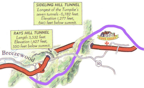
When the Turnpike opened in 1940 the four lanes of traffic narrowed to two lanes at each of seven tunnels. By the 1960's, four of the seven tunnels on the original Turnpike received a second tube to accommodate heavier traffic: Allegheny Mountain, Tuscarora Mountain, Kittatinny Mountain, and Blue Mountain. The other three tunnels were bypassed and abandoned: Laurel Hill, Rays Hill, and Sideling Hill.
Trip through the tunnels in 1953.
Laurel Hill Tunnel
The first section of abandoned Turnpike is a two-mile stretch which includes Laurel Hill Tunnel. It is located at the Westmoreland/Somerset County line and was bypassed in 1964.
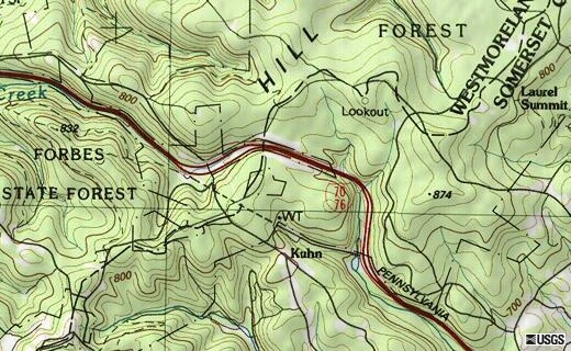
Location of the Laurel Hill Tunnel.
Rays Hill-Sideling Hill Tunnels
The second is a 12-mile stretch east of Breezewood, which is shown here. This stretch includes Rays Hill and Sideling Hill Tunnels as well as the old Cove Valley Service Plaza. It was bypassed in 1968 with a new modern section of Turnpike having a wide median and climbing lanes.
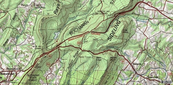 Location of the Rays Hill Tunnel, Sideling Hill Tunnel, and abandoned Turnpike. |
 The purple line is added to show the current alignment. (General Drafting) |
.focus()) |
This photograph
shows the beginning of the abandoned
section of the Turnpike, facing east. Ahead is the original 1940
alignment. The original Breezewood interchange was located here. The access highway to Breezewood veers left, leaves the old alignment, and stops at US 30. (Bernie Newman) |
.focus()) |
Looking east from the US 30 bridge.
In the center of the picture, the new alignment of the Turnpike can be seen at the Rays Hill cut. (Mike Natale) |
.focus()) |
This view is between the US 30 overpass and Rays Hill Tunnel. (Mike Natale) |
.focus()) |
This picture,
circa 1995, shows the western portal of
Rays Hill Tunnel. (Mike Natale) |
.focus()) |
This picture of the western portal was taken in the early 1980's. (Mitch Dakelman) |
.focus()) |
Taken in 1973, a few years after the Turnpike was abandoned. By comparing this with the previous two pictures, you can readily see the deterioration of the portal over the years. (Mitch Dakelman) |
.focus()) |
Looking out of the eastern portal of Rays Hill Tunnel. (Mike Natale) |
.focus()) |
Just beyond Rays Hill Tunnel. (Mike Natale) |
.focus()) |
Between Rays Hill Tunnel and the Oregon Road overpass. (Mike Natale) |
.focus()) |
Looking toward the Oregon Road overpass. The farthest point of highway visible here is almost two miles away. (Mike Natale) |
.focus()) |
Looking east with Sideling Hill
Tunnel just visible in the background. The trees in the median have since been removed. (Mike Natale) |
.focus()) |
The western portal of Sideling Hill Tunnel. (Mike Natale) |
.focus()) |
Looking east out of the western portal of Sideling Hill Tunnel. (Mike Natale) |
.focus()) |
The location of the
former Cove Valley Service Plaza is visible to the left. Although the building was torn down, the parking lot remains. (Mike Natale) |
.focus()) |
Looking east from the overpass. The jointure of the highway and the new Turnpike is located just out of view in this picture. (Mike Natale) |
.focus()) |
The old alignment converging with the new alignment is visible in the background in this view taken at the eastern end of the tour. (Mike Natale) |
.focus()) |
Looking west toward the overpass. (Mike Natale) |
.focus()) |
From atop the overpass, looking west. The basketball hoop and picnic table belong to a home, which is out of view to the left in this photo. (Mike Natale) |
.focus()) |
Looking west at Cove Valley Service Plaza. (Mike Natale) |
.focus()) |
West of Cove Valley, approaching
the eastern portal of Sideling Hill Tunnel. (Mike Natale) |
.focus()) |
The eastern portal of Sideling Hill Tunnel. (Mike Natale) |
.focus()) |
Taken inside the western end of Sideling Hill Tunnel, looking west. (Mike Natale) |
.focus()) |
Immediately outside the Sideling Hill Tunnel looking westward. (Mike Natale) |
.focus()) |
Looking west between the tunnels,
with the Oregon Road overpass in the foreground. (Mike Natale) |
.focus()) |
The eastern portal of Rays Hill Tunnel is shown in this photo. At 3,500 feet in length, it was the shortest tunnel on the Turnpike and only needed ventilation fans at the western end. This picture was taken in the early 1980's, when two of the letters ("RA") spelling out the tunnel name were still attached. (Joey Koldys) |
.focus()) |
Looking west, just west of Rays
Hill Tunnel. An underpass for a local highway is in the foreground. In the early 90's, the PTC repaved one lane here to test out rumble strip patterns (SNAP-Sonic Nap Alert Pattern). The new guardrail on the right side also dates from that era. (Mike Natale) |
.focus()) |
This picture, taken just before
the US 30 overpass, shows the Breezewood end visible in the background. (Mike Natale) |
.focus()) |
Back to the beginning of the tour, with the
Breezewood access highway in the background. (Mike Natale) |
.focus()) |
Looking eastbound behind the Ramada in Breezewood,
which is the start of the Super Highway Trail. (Jeff Kitsko) |
.focus()) |
Facing the current exit, which was the original
Turnpike. Traffic is waiting to enter US 30 to continue onto the section of Interstate 70 that comes up from the Maryland border. A direct connection is impossible and unlikely to be built. (Jeff Kitsko) |
.focus()) |
Farther away from the western end atop the US 30 overpass. (Jeff Kitsko) |
.focus()) |
Looking westbound on US 30 towards Breezewood. (Jeff Kitsko) |
.focus()) |
Western portal of the Rays Hill Tunnel. (Jeff Kitsko) |
.focus()) |
The eastern ventilation room-less portal of the Rays Hill Tunnel. (Jeff Kitsko) |
.focus()) |
The Turnpike east of Rays Hills facing eastbound. (Jeff Kitsko) |
.focus()) |
The right-of-way between the two hills and those
tunnels, which bear their names, just south of Valley Lake. (Jeff Kitsko) |
.focus()) |
In the early years, tunnel lighting was provided by
these recessed fixtures. They were harder to maintain than the current fluorescent lighting used today. (Jeff Kitsko) |
.focus()) |
View of the Turnpike from the Sideling Hill Tunnel
maintenance building. (Jeff Kitsko) |
.focus()) |
View of the old ventilation fans still residing in
the western portal of the Sideling Hill Tunnel. (Jeff Kitsko) |
.focus()) |
Eastern portal of the Sideling Hill Tunnel. (Jeff Kitsko) |
.focus()) |
Looking westbound from the location of the former
Cove Valley Service Plaza. (Jeff Kitsko) |
.focus()) |
Communications tower which is located at the
Sideling Hill Service Plaza, the replacement for Cove Valley, which shows how close they are to each other. (Jeff Kitsko) |
.focus()) |
The area where the group of trees are is where the
Cove Valley plaza building once stood. (Jeff Kitsko) |
.focus()) |
Former location of the gas pump islands, which sat
on the western side of the plaza. The lines on the pavement are not original, but were painted by the Pennsylvania State Police when they used this area as a gun range. (Jeff Kitsko) |
.focus()) |
Looking eastbound from Cove Valley towards the point where the two alignments rejoin, with Scrub Ridge in the background. (Jeff Kitsko) |
Links:
Pennsylvania Turnpike
The Abandoned Pennsylvania Turnpike - Federal Highway Administration
The
Abandoned PA Turnpike Tunnels Circa 1981/82 - Adam Prince
Abandoned PA
Turnpike - Steve Alpert
Abandoned
Pennsylvania Turnpike - Ray Plazek
Trip 2002-Pennsylvania
Turnpike - John Barrack/John Stephens