Slicing through the central part of the state, much like the river of its namesake, US 111 was the successor to the PA 4 designation on much of the Susquehanna Trail in 1928. When the US routes were first planned, US 111 was to have only gone as far north as Harrisburg, which is how it would end up. By the time the Department of Highways ironed out issues it had with the American Association of State Highway Officials' proposed alignments in the state, the designation would run between Maryland and the New York state line. The reason for that latter terminus is that, while the Department of Highways wanted as many US routes as possible (just not immediately in 1926), New York was at the other end of the spectrum and wanted as few as possible. That is why this route, US 106, and US 309 all ended at the state line over their respective life spans.
Entering the state from Maryland, the route was known locally as Main Street in Shrewsbury and Loganville, George Street and West 11th Avenue in York, Old Trail Road, and Old York Road before entering Cumberland County. There it was signed on Bridge Street, Third Street, and Market Street in Lemoyne before turning to cross the Susquehanna River into Harrisburg on the Market Street Bridge. On the eastern shore of the river, US 111 was signed on Front Street in Harrisburg which became River Road after leaving the city limits, Allegheny Street in Dauphin and Gap View Road after leaving that borough, then crossing the Susquehanna River back to its west shore.
In Clarks Ferry, US 111 joined its parent route, US 11, and was multiplexed with it to Northumberland. Along the way, it deviated from the current roadway on sections of Old Trail Road, traversed New Buffalo on said roadway as well as Mill Street, followed Front Street through Liverpool, Main Street through Trevorton, and Market Street through Selinsgrove. Arriving in Northumberland, US 111 turned to follow Duke Street and Susquehanna Trail to Milton, where it followed Front Street, then onto Muncy where it followed Main Street. It continued onto what is currently SR 2014 and Lycoming Mall Drive to Broad Street through Montoursville then Third Street through Faxon before entering Williamsport. There it followed Washington Street, Market Street, Seventh Street, Hepburn Street, Park Avenue, High Street, and High Road before exiting the city on Lycoming Creek Road which it followed to Trout Run where it returned to Susquehanna Trail north to Mansfield. In that borough as well as in Tioga and Lawrenceville, it followed Main Street, and in between, Susquehanna Trail. Due to New York's resistance to US routes, US 111's northern terminus was the state line just north of Lawrenceville.
 |
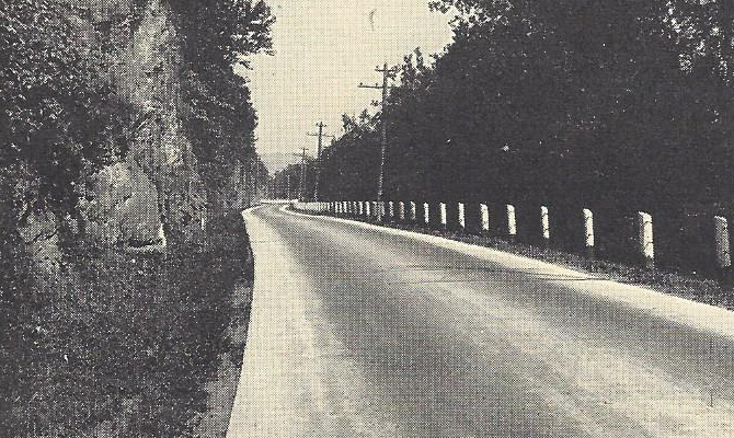
| US 111 near Liverpool in Perry County in 1929. (Pennsylvania Department of Highways) |
Improvements were already taking place when the designation came into existence in the state in 1928, as that year the route was under construction from Harrisburg to Heckton and Bloosburg to Covington. The work on both sections would conclude a year later.
The 1930s were a decade of change for US 111's alignment, mostly in Williamsport. In 1931, the route was eliminated from West Seventh Street between Market Street and Hepburn Street, and it instead was rerouted to follow those two streets between the two points. Three years later, it was once again rerouted between Market Street and Hepburn Street and this time placed on Harris Place between the two streets. That didn't last long, as the designation was removed from Harris Place and once again followed Market Street to Hepburn Street in 1935. All of those changes were made moot when in 1936, the route was decommissioned north of Lemoyne and truncated at US 11/US 15 on Market Street there which became the new northern terminus.
 |
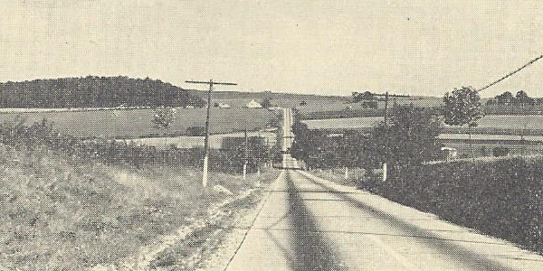
| A section of US 111 near Shrewsbury in York County in 1930. (Pennsylvania Department of Highways) |
Whereas the 1930s saw changes IN the route, the 1940s would see changes TO the route through improvement projects involving widening the roadway. In 1940, the route was widened between Marsh Run Road in York County and New Cumberland, with work taking place a year later between York and North York on North George Street. After the conclusion of World War II, the portion between Seaks Run Road and PA 216 in York County was widened in 1946. In the final year of the decade, the section between Yocumtown Road and the Valley Road/Wyndamere Road intersection in York County was widened.
Upgrading the route would take a giant leap forward during the 1950s, as construction would commence on the first piece of expressway between the Yocumtown and Turnpike interchanges in 1950. The route would also be widened that year between Seaks Run Road and Glen Rock Road also Greenbrier Drive and Leaders Heights Road, which included a middle passing lane for each direction of travel, or "suicide lane," from Lake Williams to Leader Heights Road. In 1951, the route was widened between New Cumberland and Lemoyne. A lot took place in 1952 with regard to changes in the route between the directions of travel being split in downtown York with southbound traffic remaining on George Street, while northbound traffic was placed on East Jackson Street, South Duke Street, North Duke Street, and East North Street and the expressway opening between Yocumtown and the Turnpike. The latter caused the US 111 designation to be removed from Old Trail Road and Old York Road, but since the expressway ended at the interchange with the Turnpike, US 111 was rerouted between the new alignment and old alignment via Lewisberry Road. While that section opened, construction began on the next section from the Turnpike interchange to South Third Street in Lemoyne. In 1953, the route was widened between North York and the Lightner Road/Gwen Drive intersection. In 1954, the expressway section between the Turnpike and South Third Street opened which removed the designation from Lewisberry Road, Susquehanna Trail, and Bridge Street between the two points. Even though the expressway was built, only northbound traffic could use it between the Lowther Street and South Third Street interchanges, while southbound traffic used Lowther Street itself between South Third Street and the expressway. While that section opened, construction began on the section between the Zions View/Strinestown and Yocumtown interchanges also in 1954.
Work to replace the former roadway with a limited-access alignment really ramped up in the second half of the 1950s, beginning with the section of expressway between the Zions View/Strinestown and Yocumtown interchanges opening in 1955 and the designation removed from the Susquehanna Trail and Old Trail Road. However, the original route was not forgotten as it was widened from Leader Heights Road to Grantley Road south of York as well that year. Construction began in 1956 on the section of expressway between North George Street and the Zions View/Strinestown interchange. That section opened to traffic and the designation was removed from West 11th Avenue and the Susquehanna Trail while construction began on the section from the Maryland state line to South George Street at the Spring Garden Township/City of York line and around the east side of York to the North George Street interchange the following year. In 1958, construction began on the expressway alignment from South Third Street in Lemoyne to Paxton Street in Swatara Township, east of Harrisburg. The final year of the 1950s saw the opening of the largest section of US 111 expressway with the section from the Maryland state line to South George Street at the Spring Garden Township/City of York line and around the southeastern side of York to the PA 74 interchange. With that opening, the US 111 designation was removed from the Susquehanna Trail between the Maryland state line and the point where the new expressway intersected South George Street and placed on the new parallel limited-access highway. However, the towns along the way received a "consolation prize" in the form of Alternate US 111 being designated along the previous alignment.
The first year of the 1960s would see the opening of two sections of expressway from PA 74 to North George Street, which removed the designation from passing through the city, and from South Third Street in Lemoyne to Front Street in Harrisburg. Southbound traffic would finally be able to use the expressway between the South Third Street and Lowther Street interchanges and both directions of US 111 would be signed together between Maryland and Lemoyne, and it would be joined by the designation that would ultimately replace it, Interstate 83. On September 12, 1960, the Department of Highways submitted an application to the American Association of State Highway Officials to extend the designation from Lemoyne to US 22 to provide a temporary route while construction continued to finish Interstate 83. The Maryland State Roads Commission also submitted an application on November 21 to move US 111 onto their section of Interstate 83, but with a caveat that once it was finished between US 1 in Baltimore and the Baltimore Beltway (Interstate 695), the US 111 designation would be retired. Both applications were approved by the US Route Numbering Committee on November 25 and AASHO's Executive Committee approved it the following day at their meeting in Detroit that year. In 1961, the expressway opened between the Front Street and Paxton Street interchanges and the northern terminus moved from Alternate US 11 at Market Street in Lemoyne to US 22 in Colonial Park via Paxton Street and a piece of expressway between the Paxton Street/Eisenhower Boulevard intersection and US 22 which was built between 1952 and 1954.
The end came for US 111 on August 8, 1962, when the Maryland State Roads Commission informed the American Association of State Highway Officials that they would be retiring the designation with editions of their 1963 road maps due to completion of Interstate 83 within their state. In conjunction with Maryland, the Pennsylvania Department of Highways submitted their application on September 18, 1962 to do the same within the Commonwealth. AASHO agreed and placed it on the agenda for their US Route Numbering Committee meeting on December 1, which they approved. Much like the famous US 66, the demise of this route was caused by the Interstate System, but unlike that famous route, US 111 was replaced by just one Interstate designation.
|
| Southern Entrance: | Maryland state line three and one-half miles south of Shrewsbury |
| Northern Terminus: | US 22 in Colonial Park |
| Length: | 49.15 miles |
| Names: | Harrisburg-York-Baltimore Expressway, Paxton Street, and Eisenhower Boulevard |
| LR Designations: | 127 Parallel: Maryland state line to the South George Street interchange 789: South George Street interchange to the North George Street interchange 333: North George Street interchange to the Dauphin County line 767: Cumberland County line to the Paxton Street interchange 139 Spur: Paxton Street interchange to the South 40th Street interchange 139 South 40th Street interchange to Eisenhower Boulevard 768: Paxton Street to US 22 |
| Counties: | York, Cumberland, and Dauphin |
| Multiplexed Routes: | I-83 US 322: Front Street to Eisenhower Boulevard |
| Expressway: | Maryland state line to Paxton Street in Swarta Township Paxton Street to US 22 |
| Former Designations: | US 422 (1936 - 1961): Paxton Street to Eisenhower Boulevard By-Pass US 230 (1952 - 1961): Paxton Street to US 22 |
| Decommissioned: | 1962 |
| Replaced By: | I-83 |
| Links: | US 111 Auxiliary Routes Interstate 83 End of Historic US Highway 111 - Dale Sanderson |
 Harrisburg-York-Baltimore Expressway
 INFORMATION