The sister highway of US 309, US 611 was signed in 1928 as the other of the two main routes that connected Philadelphia to the Allentown/Bethlehem/Easton and Scranton/Wilkes-Barre urban areas. Replacing PA 2 on the Lackawanna Trail, it began in Philadelphia at US 30/Vine Street, followed North Broad Street and Old York Road to Willow Grove where it was signed on Easton Road which it followed to Doylestown. After passing through the seat of Bucks County on Main Street, it continued to follow Easton Road. In Easton itself, the route followed South Delaware Drive, Third Street, Bushkill Drive, and North Delaware Drive before continuing north to Martins Creek where it was posted on Main Street, Lower South Main Street, and South Main Street to Bangor. From Bangor, US 611 followed Mount Bethel Highway to rejoin North Delaware Drive and onto State Street to Portland. There it followed State Street and Delaware Avenue, then paralleled the Delaware River to Delaware Water Gap. In that borough, the designation turned onto Broad Street and continued north, crossing Brodhead Creek onto Post Office Road and River Road through Minisink Hills where it turned onto Hillside Drive. From that intersection into East Stroudsburg, US 611 was posted on Seven Bridge Road to East Brown Street. After passing through East Stroudsburg on that roadway as well as Prospect Street, Ridgeway Street, Brown Street, and Main Street which it continued into Stroudsburg on then turned on North Ninth Street to continue north on the Lackawanna Trail through Tobyhanna, Moscow, and Elmhurst. Approaching Scranton, the designation followed East Drinker Street, South Blakely Street, and Green Ridge Street before ending at the US 11/North Main Avenue intersection in the northern end of the city.
In its first year of existence, the roadway was under construction between Clifton Beach Road and Daleville in Lackawanna County, which was completed in 1929.
The 1930s seemed to be the decade of change, at least in the routing of US 611. In 1930, the northern terminus was moved to the intersection of South Blakely Street and Green Ridge Street in Scranton due to US 11 being rerouted onto those two streets. Three years later, the designation was changed between Martins Creek and the intersection with Mount Bethel Highway south of Mount Bethel to create a more direct path versus traffic traveling through Bangor. Due to the change, the PA 827 designation was decommissioned between Martins Creek and the intersection with Martins Creek-Belvidere Highway. Also in 1933, the designation was changed between Delaware Water Gap and Stroudsburg to eliminate the circuitous routing that took it around Godfrey Ridge and through Minisink Hills and East Stroudsburg. Just as in Northampton County, the change in the US route replaced a state route, this time being PA 612.
Not only were changes IN the route of US 611 taking place, but also TO the route. The final year of the 1930s saw widening projects take place between Willow Grove and Plmsteadville as well as from Delaware Water Gap to Stroudsburg. These improvements saw the addition of a third lane on either side of the existing two lanes, which created a center passing lane that either direction of travel could use, which were referred to as a "suicide lane."
Work to widen the highway continued into the 1940s when in 1940, the sections from Portland to Slateford and Drinker Turnpike to Scranton were widened to three lanes while the part from the Monroe County line to the PA 307 intersection was widened to four. That same year, the northern terminus was moved once again, this time to the intersection with US 6 and US 11 at West Market Street in Scranton. US 611 was extended back along Green Ridge Street, where it was signed for the first two years of its existence, and along North Main Avenue to end at Market Street, ironically, at the two route numbers that made up its number. Construction began in 1940 on a new section of three-lane roadway between the two intersections of Hemlock Drive, which originally carried the US 611 designation, south of Tobyhanna and opened the following year. The same year, 1941, saw sections from PA 507 to the Lackawanna County line widened to four lanes, while PA 348 to just before the first bend north of that intersection widened to three lanes.
After the conclusion of World War II, the route was extended north and the northern terminus moved to the intersection of US 6 at the traffic circle in the northern part of Scranton where West Market Street and the Roosevelt Highway intersected. Improvements to the route resumed with the highway being widened to four lanes with a median between Cheltenham Avenue in Philadelphia and Washington Avenue in Jenkintown and again from Cloverly Avenue to Willow Grove in 1946. It was only widened to four lanes, undivided, between Washington Avenue and Cloverly Avenue. The same year, US 611 was widened to three lanes between Stroudsburg and Tannersville. Two years later, in 1948, the highway was widened to three lanes between Tannersville and the southern intersection with Hemlock Drive as well as from the northern intersection with Hemlock Drive to PA 507. The latter section involved construction of a completely new alignment between Main Street southeast of Tobyhanna to PA 507. Also in 1948, the northern terminus was moved once again in Scranton, this time to the intersection of West Market Street and North Keyser Avenue when US 6 rerouted.
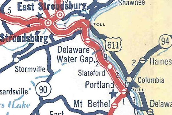
The Delaware River Joint Toll Bridge Commission started construction of the Portland-Columbia and Delaware Water Gap toll bridges on October 15, 1951, along with new roadways that connected to the existing alignment of US 611. Nearly a year after construction had begun, the Pennsylvania Department of Highways and the State Highway Department of New Jersey petitioned the American Association of State Highway Officials to change the route of US 611. Both agencies requested the change in conjunction with the move of the US 46 designation out of Pennsylvania and making that route an intrastate one, which it is to this day. Besides construction of the two toll bridges, New Jersey desired to connect both spans with a four-lane, divided highway which eventually would become part of Interstate 80. AASHO's US Route Numbering Committee approved the move of US 611 to the eastern shore of the Delaware River as well as the creation of Alternate US 611 to fill the void between Portland and Delaware Water Gap at their meeting on December 8, 1952, in Kansas City, Missouri, with the Executive Committee following suit with their approval at their meeting the following day. Both spans respectively opened to traffic December 1 and 15 in 1953, but signage changes wouldn't take place until the following year.
| Footage from the opening ceremonies of the Portland-Columbia and Delaware Water Gap toll bridges. (Delaware River Joint Toll Bridge Commission) |
 |
| The new routing of US 611 in New Jersey and Alternate US 611 in Northampton and Monroe counties. (Pennsylvania Department of Highways) |
Improvement projects continued in 1955 when the section from PA 307 to Moscow was widened to three lanes. In 1958, work to widen the highway to four lanes with a median separating the two directions of travel took place from Scotrun to Mount, just north of Laurel Drive to Main Street south of Tobyhanna, and PA 507 to the Lehigh River/Lackawanna County line. From Elmhurst to just south of Dunmore at the Drinker Turnpike intersection, a northbound roadway was constructed to widen US 611 to four lanes while the original alignment became the southbound lanes.
Although not due to new construction, but a change in the routing of US 611 in Easton also took place in 1958. That year the designation was removed from South Third Street north of Ferry Street, North Third Street, and College Avenue. Instead, the route's new path through the county seat of Northampton County consisted of northbound traffic using South Third Street and Ferry Street to South Second Street, while southbound traffic used South Second Street between those two points. Both directions of travel used Ferry Street and Front Street for the rest of the trip through the borough.
The last full decade of US 611's existence would see sections of limited-access roadways come to its corridor. Construction of Interstate 80 through Stroudsburg had begun in 1959 on the section between the Delaware Water Gap and Prospect Street interchanges, and was completed in 1960. In 1961, construction continued from Prospect Street to the Tannersville interchange, while work began on the first section of Interstate 81E between East Drinker Street and Interstate 81. In 1962, the section of Interstate 80 between Prospect Street and Main Street opened, as well as the section of Interstate 81E between what became the East Drinker Street on-ramp and Interstate 81.
On July 31, 1962, the Department of Highways applied to AASHO to extend US 611 to the Ninth Street interchange on the newly opened Interstate 80, and to extend Alternate US 611 over the vacated route between Delaware Water Gap and that interchange. They applied again on August 9, but with a caveat that once more of the Interstate was completed, US 611 (and all auxiliary routes) would be decommissioned entirely. The Department of Highways applied yet again on October 15, but this time, US 611 would be placed on Interstate 80 from New Jersey to the Scotrun interchange while Alternate US 611 would replace US 611 between Delaware Water Gap and the Scotrun interchange. AASHO approved the move of US 611, but the Alternate US 611 extension was denied by both the US Route Numbering Committee on December 1, 1962 and the Executive Committee the following day. While denying the extension, the Executive Committee recommended that a business route be used for the entire corridor rather than extending the alternate route, and if that was agreeable, the Department of Highways should submit an application for their meeting in Summer 1963.
The Department of Highways pushed for the extension of Alternate US 611 once again on Valentine's Day 1963, citing several reasons such as the toll bridges on the main route as well as a plan to move US 611 to what would become the PA 33 corridor which would eliminate the need for US 611 in the Stroudsburg area and Alternate US 611 entirely. A. E. Johnson, Executive Secretary of the American Association of State Highway Officials, wrote to the members of the US Route Numbering Committee on May 17, 1963, that the application be reconsidered at their June 18 meeting which they denied along with the Executive Committee the following day. However, the Department of Highways seemed unfazed by the decision and went ahead with the extension of Alternate US 611 anyway, while US 611 was moved onto the newly opened section of Interstate 80 between Main Street and Scotrun.
In 1964, the roadway was widened and upgraded to a divided highway from the Bucks County line to the Sauerman Road/New Britain Road intersection in Doylestown. Meanwhile, the northern terminus was moved out of Scranton completely, removed from East Drinker Street, South Blakely Street, Green Ridge Street, North Main Avenue, and West Market Street, and placed on the new section of Interstate 81E with its terminus now at the interchange with Interstate 81. That same year, the State Highway Department of New Jersey petitioned the American Association of State Highway Officials to delete US 611 in the Garden State and have it moved back to the western shore of the Delaware River between Portland and Delaware Water Gap. The Pennsylvania Department of Highways followed suit with their paperwork on October 14, just six days shy of the October 20 deadline to make the agenda for AASHO's meetings on December 5 and 6. They gave three reasons for the change: elimination of the needless Interstate 80/US 611 multiplex, to provide a traffic route for the highly commercialized Pocono resort area, and to avoid directing traffic over toll bridges at Portland and Delaware Water Gap. Many motorists objected to having to pay tolls to follow US 611 when a shorter, toll-free route was available. The US Route Numbering Committee approved the applications on December 5, and the AASHO Executive Committee doing the same a day later. US 611 moved back to its previous alignment between Portland and Scotrun and once again became an intrastate route in 1965. Harold Kresge, administrative officer for the Pennsylvania Department of Highways District 5 said the sign changes would be complete by April 1.
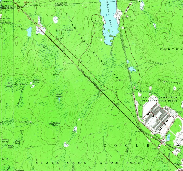
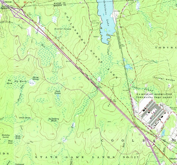
Construction began in 1968 on Interstate 81E between PA 423 and PA 507 in Monroe County, with the US 611 alignment between those two points being used for the northbound lanes. In states out west and in the Great Plains, it was commonplace to use an existing roadway and just lay down another set of lanes on either side, but virtually unheard of in eastern states due to the frequency of houses and businesses along its roads. However, there were none of either because the roadway straddled Gouldsboro State Park to the northeast and state game lands to the southwest. This section of Interstate would open two years later in 1970.
 |
 |
| The route of US 611 in 1965 (left) and the former route in 1973 (right) between PA 423 and PA 507 in the Tobyhanna area. Interstate 81E's northbound lanes were the former US 611 right-of-way, while the original alignment paralleled both to the northeast. (USGS) | |
The end of the line came for US 611 on December 3, 1971, when the American Association of State Highway Officials' US Route Numbering Committee approved PennDOT's application to fully decommission the route between Philadelphia and Scranton. One reason for its elimination was that it was completely within the Commonwealth, as well as being less than 300 miles in length, which violated a policy that was established by AASHO effective January 1, 1959 that stated any US route less than 300 miles in length and/or within one state should be eliminated. The Executive Committee concurred with the decision the following day. However, it wasn't until March 14, 1972, that PennDOT officially announced it was decommissioning US 611 and would be replacing it with PA 611 from Philadelphia to its interchange with Interstate 81E at Tobyhanna and PA 435 from the Gouldsboro interchange to the Dunmore interchange on Interstate 81E. Work to change out the US 611 markers for PA 611 and PA 435 markers continued into April.
|
| Southern Terminus: | US 30/Vine Street in Philadelphia |
| Northern Terminus: | I-81 in Dunmore |
| Length: | 127.51 miles |
| Names: | North Broad Street, Old York Road, Easton Road, South Main Main, North Main Street, South Delaware Drive, South Third Street, Ferry Street (northbound), Front Street, North Riverside Drive, North Delaware Drive, Delaware Avenue, Main Street, Foxtown Hill Road, Park Avenue, South Seventh Street, North Ninth Street, Pocono Boulevard, Memorial Boulevard, Drinker Turnpike, and Lackawanna Trail |
| LR Designations: | 214: US 30 to the Montgomery County line 151: Philadelphia County line to State Street in Doylestown 156: State Street to Northampton Street in Easton 165: Northampton Street to Front Street and Main Street in Martins Creek 48025: Front Street and Main Street to Belvidere-Martins Creek Highway 48027: Belvidere-Martins Creek Highway to the Upper Mount Bethel Township line A2842: Washington Township line to Mount Bethel Highway in Upper Mount Bethel Township 166: Mount Bethel Highway to Broad Street in Delaware Water Gap, Main Street and North Seventh Street to South Ninth Street and Main Street in Stroudsburg 498: Broad Street in Delaware Water Gap to Main Street in Stroudsburg 168: Main Street in Stroudsburg to I-81E and PA 507 to the East Drinker Street on-ramp 1002: Tobyhanna to PA 507 790: East Drinker Street on-ramp to I-81 |
| Counties: | Philadelphia, Montgomery, Bucks, Northampton, Monroe, Wayne, and Lackawanna |
| Multiplexed Routes: | Business US 209: Main Street to Ninth Street in Stroudsburg I-81E: Tobyhanna to PA 507 and East Drinker Street on-ramp to I-81 |
| Expressway: | Tobyhanna to PA 507 East Drinker Street on-ramp to I-81 |
| Former Designations: |
PA 2 (1925 - 1928): Philadelphia to Martins Creek and Mount Bethel to Scranton PA 53 (1927 - 1928): Doylestown to West Swamp Road PA 32 (1927 - 1928): Delaware Water Gap to Stroudsburg PA 12 (1927 - 1928): East Stroudsburg to Stroudsburg PA 75 (1927 - 1928): Daleville to Moscow PA 302 (1928 - 1930): Bangor Mountain Road/Broad Street to Stroudsburg PA 612 (1928 - 1933): Delaware Water Gap to Stroudsburg PA 827 (1929 - 1933): Martins Creek to Martins Creek-Belvidere Highway Alternate US 611 (1954 - 1965): Portland to Delaware Water Gap Alternate US 611 (1963 - 1965): Delaware Water Gap to Scoturn |
| Decommissioned: | 1972 |
| Replaced By: | PA 611: Philadelphia to Martins Creek and Mount Bethel to Tobyhanna I-81E: Tobyhanna to PA 507 and the East Drinker Street on-ramp to I-81 PA 435: PA 507 to I-81E |
| Links: | US 611 Auxiliary Routes PA 611 Old US 611 Pictures - Steve Alpert End of Historic US 611 - Dale Sanderson |
 Lackawanna Trail
 INFORMATION