Veterans Memorial Highway
Pennsylvania Turnpike Northeast Extension
Veterans Memorial Highway
Pennsylvania Turnpike Northeast Extension
One of the last Interstates to be completed in Pennsylvania, which is ironic since it had been proposed since 1929. The purpose of the highway was to create a better route from Chester to the Norristown area. In 1932, the Regional Planning Federation, the forerunner to today's Delaware Valley Regional Planning Commission, proposed a New York City-like parkway along the current right-of-way, complete with stone-arch bridges and natural landscaping. However, the plan fell through and no expressway was built.
Initially, this project was under the guidance of the Pennsylvania Turnpike Commission, which incorporated the 1929 plan. In the early 1950s, before the Interstate Act was passed, the state proposed a system of limited access toll highways that followed the routes of the current Interstates. I-476, or the Chester Extension as the Turnpike Commission referred to it as, was projected to be constructed as one of these toll routes. The highway would start near Chester and connect with the Turnpike at the Northeast Extension Interchange.
In 1956, the Federal Highway Act was signed into law by President Eisenhower, and brought the PTC's grandiose plans to a grinding halt. Construction of the Mid-County Expressway would now be the job of the Pennsylvania Department of Highways. They devised three routes for the expressway through Delaware and Montgomery Counties:
.focus()) |
Map showing the differences in the three routes. (Pennsylvania Department of Highways) |
The latter route was chosen as the preferred alignment, and its name stuck. Interstate 476 was termed the Blue Route during the initial planning and construction due to its color on planning maps. Even today, traffic reports in Philadelphia differentiate this section from the Turnpike section by referring to it as "The Blue Route." At the beginning of the movie The Sixth Sense, which was set in Philadelphia, you can hear a traffic reporter use "Blue Route."
As the years wore on, protesting and not construction seemed to be the norm for the expressway. It was not for fear of taking houses, which the Blue Route was routed to take fewer than the other proposals, but that the expressway would disrupt the Darby Creek and Crum Creek valleys. By 1964, dust was not rising from the project but the cost was, and topping out at $78 million by 1964. In 1970, two sections opened: a two and a half mile section through Broomall and Bryn Mawr and another mile and a half section through Radnor. It was a case of "two steps forward, one step back" as neither section connected to any highways or streets and both would sit devoid of traffic for nearly two decades.
The Department of Highway's maps from the mid-1960s showed the route with the words "OPEN MID 1970" and so on until 1972. Then it was dropped to just show the route when it was apparent that the highway was not going to be completed and for good reason. By the 1970s, new Federal and state environmental regulations gave the opponents of the Mid-County Expressway new ammunition. Between 1970 and 1972, environmental impact studies were performed as a new part of the process of Interstate construction. Previous studies were made null and void under the new laws, and therefore the entire 21.5-mile length of the Blue Route had to be re-evaluated. Although, construction still continued on the interchanges at Interstate 76 and Interstate 95 since they were already under contract.
One of many protests against I-476.
(Philadelphia Inquirer)
Between 1976 and 1978, PennDOT conducted public hearings on the draft and final environmental impact statements. The expressway would feature six lanes and have interchanges at US 1, PA 3, US 30, and a partial one at PA 320. Originally interchanges would have also been constructed for the Lansdowne Expressway near mile marker seven and the Radnor Spur of US 422 in Radnor Township, but those expressways were cancelled in 1977 by PennDOT. Lost in all the protesting and hearings, the first section of the Blue Route from from I-76 to Exit 19 managed to open in 1979.
Word came down in March 1979 from the Federal Highway Administration that it would not accept the final environmental impact statements unless PennDOT spelled out the number of lanes and interchanges, PennDOT's financial standing, and how SEPTA mass transit could interface with the Interstate. A task force was organized by the Department of Transportation to study these issues and devise a revised environmental statement. The results were submitted to the FHWA in May 1980, and in August of that year they approved the plans. The celebration would be short lived when in November 1981, the Townships of Marple, Radnor, Ashwood Manor and Swarthmore with the Citizens Council of Delaware County won an injunction to stop construction in US District Court.
PennDOT would not be denied their Interstate, and drafted two new environmental impact statements for the missing links in 1983. The expressway would be four-lanes south of PA 3 and six-lanes north of that interchange, with both sections featuring 12-foot-wide lanes, 10-foot-wide shoulders, variable medians, and a 65 MPH design speed. The section south of PA 3 would be a parkway-like highway, less evasive right-of-way acquisitions in respect to residences, parklands, and historic sites. Sound walls with pockets to allow vegetation to grow and therefore blend in with the surroundings were installed. From Ridge Pike to the Turnpike, the expressway would be six lanes and tie into Interstate 276 with a massive interchange comprising a 17-lane toll plaza, seven bridges, and 4.4 miles of ramps. The statements for each section also provided for park-and-ride lots for four intersecting commuter rail lines, which was something noticeably missing from the original 1950s plans.
Opposition to the expressway kept most of the project in legal battles, mainly with PennDOT being the object of law suits over wetland protection issues. It wasn't until 1985 when a Federal judge dismissed the suits and gave the go-ahead for construction provided PennDOT monitored environmental impacts during construction. In that same year, construction resumed on the section between Interstate 95 and MacDade Boulevard. That section opened on August 17, 1988 and cost $28 million to build, but was signed more or less as an interchange without any mention of I-476.
Finally on December 19, 1991, after all the protesting, arguing, and suing, the section of Interstate 476 from MacDade Boulevard to the Schuylkill Expressway opened to traffic. The remaining section from Ridge Pike to Germantown Pike opened almost a year later on December 16, 1992. The cost of the highway was tallied at $600 million, or $5,503 a foot which was a significant difference from the original proposed cost in 1957 of $40 million. This Interstate joined I-279 in Pittsburgh, I-78 in Allentown-Bethlehem, and I-676 in Philadelphia as one of the last legs of the Pennsylvania Interstate System to be completed. Sadly, even before the Blue Route opened to traffic, it claimed a life of an errant driver who entered the uncompleted expressway and crashed into a construction crane.
The Turnpike section of this Interstate did not encounter as many problems getting off the ground. Ground was broken on March 25, 1954 for the spur to Scranton, which had been authorized as early as 1947.
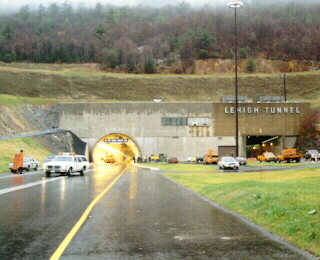
The first section of the Northeast Extension opened on November 23, 1955. Its initial 37 miles opened from a interchange east of the Norristown interchange to the Lehigh Valley interchange. Interchanges at Lansdale and Quakertown opened later on December 3 and December 10, respectively. From the Lehigh Valley interchange, another 10 miles opened to a temporary interchange at Emerald on December 28, 1955. Work was still taking place to build the two-lane, 4,461-foot-long tunnel through Blue Mountain. It was named Lehigh Tunnel so as not to be confused with the tunnel through the same mountain on the main line Turnpike. It would been named after commission chairman Thomas J. Evans if he hadn't been convicted of conspiracy to defraud the PTC of $19 million on July 25, 1957.
On April 1, 1957, the Northeast Extension was opened to the Wyoming Valley interchange near Wilkes-Barre. At this time, the temporary interchange at Emerald closed. The last 16 miles to Scranton opened on November 7, 1957. With the opening, it brought the Northeast Extension's total length to 110 miles, and the total system length to 470 miles.
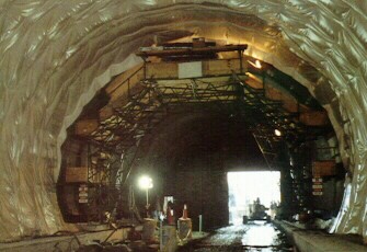
Since the popularity of the Poconos had increased, so did the traffic that resulted in 22,000 vehicles a day during August: the busiest time of the year. In 1988, a contract to widen the Lehigh Tunnel on the Northeast Extension was awarded for $37 million. On February 14, 1989, ground was broken on the second tunnel. A new method to constructing this tunnel was implemented. The other tunnels were constructed by blasting rock loose, then clearing the debris and erecting a steel superstructure inside the tunnel which was repeated many times until the tunnel was completed. The new technique is called the New Austrian Tunnel Method (NATM), and this was the first highway project in the United States to use NATM. It has been used in Europe since the 1950s, it had been utilized in two light rail projects: the Mount Lebanon Transit Tunnels in Pittsburgh and Washington Metro system. With the technique, after each blasting of rock, the ceiling and sides are stabilized by being sprayed by shotcrete. The 4,380-foot-long tunnel was bored 94 feet west of the existing tube and was "holed through" on June 12, 1990. The men, working three shifts, 24 hours a day, six days a week had tunneled 3,550 feet through the north side of the Blue Mountain and and 675 feet through the south side.
Two American contracting firms and one Nova Scotian firm handled the construction. Pennsylvania designers of the new tunnel are the engineering firms of GSGSB of Clarks Summit, and McCormick, Taylor and Associates of Philadelphia. Two tunneling consultants, Dr. Gerhardt Sauer Company of Herndon, Virginia, specialists in the NATM technique, and Michael Baker Jr., Inc. of Pittsburgh, engineering consultants to the Turnpike Commission also worked on the project.
The new tunnel opened to traffic in November 1991, and eliminated the last two lane section of the Turnpike. When it opened, the original tube was closed for refurbishing. This would eliminate the last section of two lane roadway on the system.
|
|
|
|
In late 1989, ground was broken on the Mid-County Interchange in Plymouth Township, Montgomery County. This project included the largest contract awarded by the Pennsylvania Turnpike Commission. The interchange is the largest in the system and the first additional interchange on the mainline to be constructed since completion of the Scranton Interchange, now named Clarks Summit, on the Northeast Extension in 1957. The interchange has the largest toll plaza with 17 lanes for entering and exiting traffic and eight ramps comprising 4.4 miles. The Mid-County and Norristown Interchanges are connected via a fiber optic cable which permits data sharing between the toll plazas and the main office in Harrisburg.
A $55 million general construction contract was awarded to the Hull Corporation of Syracuse, New York in late 1989. This included construction of the toll plaza, utility building, roadway, structures, signing, and lighting.
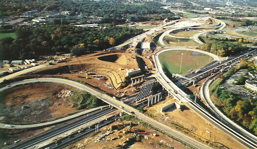
Mid-County Interchange under construction. The old Northeast Extension
interchange bridge
is in the foreground. (Pennsylvania Turnpike Commission)
In 1990, the PTC awarded contracts totaling $131,000 to the Hull Corporation for heating, ventilation, and air conditioning. Thomas M. Durkin and Sons' contracted to handle wetland replacement totaling $316,097.
|
|
|
|
Since the construction took place in a highly developed area of suburban Philadelphia where there are many active roadways, maintaining a smooth traffic flow posed a challenge. To prevent problems, the project was divided into phases and stages. The purposes of this was to maintain at least four lanes of traffic on the mainline Turnpike and to provide access to the Northeast Extension while the ramps were under construction. Solution cavities posed an even greater problem to the construction. These are formed when groundwater has worn away earth between limestone rocks, thus creating an underground cavern. To guarantee that the bridge supports at the south end of the culvert for the Plymouth Creek sat on firm ground, an addition $400,000 was needed. This paid for extra excavation and concrete work. A concrete grout mixture was pumped underneath and around the bottom of the bridge pilings required an additional $350,000. On December 15, 1992, the first interchange on the Turnpike to have "fly over" ramps opened.
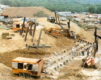
Grout being pumped into underground voids
(Pennsylvania Turnpike Commission)
This would not be the last interchange to be added. The Keyser Avenue interchange was added in the early 1990s. Construction began in February 1991 on the interchange that served as the final exit on the Northeast Extension while the Wyoming Valley mainline toll barrier was built and the Scranton Interchange underwent reconstruction. The interchange was designed by Gannett Flemming, Inc. of Camp Hill and American Asphalt Paving of Shavertown performed the construction. Wyoming Sand and Stone supplied materials for the project. The interchange completely opened in 1992 which signaled the completion of Interstate 476.
As mentioned above, work also began on the mainline north of the Wyoming Valley interchange. An $11 million project began on March 19, 1991 with the demolition of the old Wyoming Valley interchange and construction of a seven lane mainline barrier two and a quarter miles south. This is now where the ticket system ends, because from that point north the highway is a coin drop system as on the toll highways in Southwest Pennsylvania. In November 1992, this section of the Turnpike reopened to traffic.
In 1996, the Turnpike Commission lobbied to have the Interstate 476 designation extended north of the Mid-County Interchange and the entire length of the Northeast Extension. The official designation change occurred on November 1 of that year. Prior to that, the section from Exit 20 to Exit 131 was designated as PA 9. So as not to confuse travelers, and to mark every section of the Turnpike as I-76 or an I-x76, the Federal Highway Administration granted the designation change.
E-ZPass, an electronic toll collection system, was unveiled on December 2, 2000 between Exits 20 and 56 and then extended to the Wyoming Valley Toll Barrier on May 19, 2001. Commercial vehicles were allowed to use it for the first time on December 14, 2002. The Keyser Avenue and Clarks Summit Toll Plazas were incorporated into the E-ZPass system on November 23, 2004. This system is, or will be, used for toll collection on every toll highway and bridge in the Northeast.
December 28, 2001 was not a good day to be on Interstate 476 as several multiple-vehicle accidents caused by snow squalls shut down the highway late that afternoon south of Wilkes-Barre. There were no injuries reported from the crashes, which occurred between Exit 95 and Exit 115.
Something travelers who use the Turnpike did not want to hear happened January 20, 2004. That day the PTC announced a toll increase of 1.8 cents-per-mile for cars and a 5.3 cents-per-mile increase for trucks which went into effect on August 1, 2004 only on the mainline and Northeast Extension. The reason for the increase was to continue to upgrade the highway. Current revenues would take upgrading the highway 104 years to complete, but with the increase, only 30 years. Also, widening in locations of bottlenecks, building new ramps, building more adequate shoulders and sound walls, eliminating dangerous curves, improving interchanges, and making the E-ZPass system work more smoothly could be achieved with more revenue. Another hike in tolls, this time 25%, would be instated on January 4, 2009 for most of the Turnpike System except for Turnpike 43's Brownsville to Uniontown section and Turnpike 576 where tolls would remain unchanged. This increase was necessitated by the signage of Act 44 in July 2007 which would provide PennDOT with $450 million a year in supplemental funding between 2007 and 2057. As part of Act 44, tolls increased 3% a year later on January 3, 2010 with the exception of Turnpike 576 again.
Ramp metering returned to the Blue Route again in the afternoon of November 16, 2004. Four signals at the northbound MacDade Boulevard, north and southbound Baltimore Pike, and southbound US 1 on-ramps were reactivated. They operated from 6:30 AM to 9 AM and 3 PM to 7 PM. PennDOT spokesman Gene Blaum said, "To make traffic flow smoother on Route 476, we want to stagger the rate at which cars enter the highway." He added, "It's a much more sophisticated system today than how the ramp meters worked between 1999 and 2001," referring to their earlier use. The difference now is that the signals can be controlled remotely as opposed to using a fixed metering rate regardless of traffic volumes. Prior to activating them in 1999, PennDOT performed a travel time study to measure peak-hour travel speeds. It showed that mainline traffic dropped from 55 MPH to 25 MPH between I-95 and PA 3, but rose back to 55 MPH about two miles away from each interchange. Another study conducted in 2005 found the average speed increased 10 to 31 MPH between MacDade Boulevard and US 1 in the morning, and three to five MPH between US 1 and Baltimore Pike and 35 MPH at MacDade Boulevard in the evening. The second activation only last four years and in 2008 they were shut off again. On January 27, 2009, PennDOT District 6-0 announced all of the ramp meters would be turned on in phases from south to north as part of the rehabilitation of the Blue Route. The reason for their reactivation was due to the installation of fiber optic lines along the expressway for ramp meters, traffic cameras, dynamic message signs, incident detectors, and replacement of ramp metering hardware and components.
Construction on the first E-ZPass-only interchange on the Northeast Extension began in mid-2009 at PA 903, which is the first new interchange to be added since Keyser Avenue in the early 1990s. The interchange was planned as far back as 1985, but was initially cancelled due to the low volume of traffic utilizing it that was projected. The demand changed with the increase in population in Carbon County between 1990 and 2005. Originally planned as a partial interchange with a northbound off-ramp and southbound on-ramp due to the majority of traffic coming from that direction, the other half was projected to be built if and when traffic warranted. The Federal Highway Administration did not like that idea and said they would only fund construction of a whole interchange. Work included construction of the on and off-ramps that became Exit 87, installation of the electronic toll collection gantries and equipment, replacement of the former PA 903 overpass, widening PA 903 at the site of the interchange, and installation of traffic signals on PA 903 at the interchange. Originally slated to open Memorial Day 2012, the $40 million interchange opened on June 30, 2015 due to issues with wetlands in the area. Local residents and businesses were thrilled by the opening of the interchange, but not all shared in that joy. In the first two weeks of operation, the interchange tallied 4,537 violators, or more than 12% of the 37,376 vehicles that used the interchange. Most of drivers received a bill for $60.11 ($25 administrative fine plus $35.11 for the toll).
The ramp meters were not reactivated until 2010, initially planned for February 9 but due to winter weather was pushed to February 24 at 3 PM. The meters that were reactivated were at the MacDade Boulevard, Baltimore Pike, and US 1 to I-476 southbound interchanges in Delaware County. State Representative William Adolph hoped they would be more effective than their predecessors, citing dangerous back ups at the US 1 interchange, saying, "It was not even enough room for the cars to get onto the ramp. They were actually in the right-hand lane of Route 1." The new system has sensors imbedded into the entrance ramps to prevent such issues, as when traffic reaches a certain level, the sensor communicates with the Traffic Management Center in King of Prussia to clear the back ups quickly. If traffic backs up to where it is spilling onto the entrance ramps, the meters can all be turned off simultaneously. The second set of ramp meters came back online at the end of March 2010 were at the US 1 to I-476 northbound, PA 3, and US 30 interchanges.

Ramp meters at the Baltimore Pike southbound on-ramp
Thanksgiving travelers got an early present on November 24 when toll collectors and maintenance personnel walked off the job for the first time in 64 years at 4 AM, forcing the PTC to wave tolls on the busiest day of the year. No major backups were reported, but traffic did slow around 5 PM near Exit 57 due to an accident. At the Bedford Interchange, two truck drivers were citied by State Police after they attempted to block the toll plaza in a show of solidarity. Teamsters Local 77 and 250 walked off the job due to not receiving raises unlike non-union employees. The Commission offered a raise of $21 per hour over three years, fully paid health care package, 15 paid holidays, an average of four weeks of vacation a year, and a no-layoff clause for three years. The union rejected the offer, but would not comment on the reason. Around 220 PTC managers were pushed into service at toll plazas across the state starting at 12:01 AM on November 25. No tickets were issued and instead a flat rate of $2 for passenger vehicles and $15 for commercial vehicles. E-ZPass customers were charged the regular fare up to $2. No tolls were collected at the Keyser Avenue and Clarks Summit Toll Plazas.
A tentative agreement was reached through negotiating sessions that began November 29 at 2:30 PM and ended on November 30 around 10 PM, ending the seven day strike. Executive Director Joe Brimmeier commended the management employees who filled in at 36 Turnpike interchanges for "their exemplary service. These men and women, representing every level of management, performed magnificently, provided a high level of customer service and ensured the safe and smooth flow of traffic during the busiest holiday travel period of the year. I cannot thank them enough for their dedication and commitment." At 9 AM on December 1, tickets began to be reissued and commercial cards accepted. An eight-hour grace period until 5 AM December 2 was allotted for travelers who entered the Turnpike when tickets were not being issued. After this period, they would be charged the lost ticket fare which is the toll from point of entry to the farthest exit. Tolls were reinstated at the Keyser Avenue and Clarks Summit Toll Plazas.
In Spring 2005, construction began to rebuild the section of Turnpike from the Mid-County Interchange to milepost 30. Initially the project focused on replacing eight overpasses, 12 mainline bridges, lengthening culverts, and construction of storm water basins and drainage improvements which ended in 2010. Ground was broken March 4, 2011, and work officially began two days later, on the first section to be rebuilt between milepost A20 and milepost A26. Aside from a completely new six-lane roadway with a 26-foot median and 12-foot shoulders with gentler curves and grades, lighting, Jersey barriers, guide rails, noise walls, and drainage was replaced. The $151 million first part was completed in October 2014, but the second half of the project from A26 to A30 began April 28, 2014 and was completed August 31, 2017. A feasibility study was conducted in January 1999 which had the original price tag at an estimated $200 million.
With time beginning to take its toll on the embattled expressway, PennDOT announced a rehabilitation project for the Blue Route which would consist of three phases. Phase One involved resurfacing I-476 from I-95 to Lawrence Road which is just south of PA 3, and I-95 in the vicinity of the interchange with I-476. Work started in early June 2005 and finished in November 2005. Phase Two involved resurfacing from Lawrence Road to I-76 and I-76 in the vicinity of the I-476 interchange, which began in March 2006 and finished in November 2006. These two phases also involved upgrading guiderail, signing, and lane markings. Phase Three involved a complete rehabilitation of the Schuylkill River Bridges including redecking both spans, strengthening the steel structure underneath, and painting. This phase began in early 2009 and finished in November 2010. Phase Four will involve extensive reconstruction from I-76 to I-276, as this is the oldest section of the Blue Route. Work during this phase will include rebuilding the concrete pavement, upgrading acceleration and deceleration lanes, replacing drainage systems, improving signing and pavement markings, rehabilitating bridges, and repairing sinkholes. This phase began in early 2009 and finished in 2012.
The first major snow storm to hit the Commonwealth in 2007 during February 13 and 14 caused something that hasn't happened since the first day of the 2004 collectors strike: a toll-free, cross-state ride. With accidents, snow, and ice closing sections of I-78, I-80, and I-81, Governor Rendell declared a statewide Disaster Emergency on February 15. Part of the declaration included eliminating tolls beginning at 9:11 PM to provide a free detour route via the mainline Turnpike and Northeast Extension. Tolls were not reinstated until February 17 at 8 PM.
With bridge replacement projects taking place for widening the roadway south in Montgomery County, another bridge replacement project began in Carbon County on December 22, 2008. Work included building two northbound and two southbound bridges across the Pohopoco Creek and Lehigh River, roadway improvements, hiking trail and wetland construction, and demolition of the original bridges. Much of the construction materials were sourced locally. Rock Hill Concrete, Inc. of Parryville was the primary concrete supplier for the job, and in fact, supplied the concrete for construction of the original bridges. The $101.6 million project concluded November 4, 2011 with a ribbon-cutting ceremony held on the northbound lanes of the Lehigh River Bridge PTC CEO Roger Nutt, state legislators, and civic and business leaders in attendance. "The new bridges offer a safety enhancement over the previous structures because they feature wider shoulders to the left and right of the travel lanes," PTC CEO Roger Nutt explained. "The shoulders provide Turnpike motorists a buffer zone in case of an accident or breakdown – something the old bridges lacked."
It takes a really big snow storm to close roads and that is exactly what hit on February 9, 2010. Governor Rendell took proactive measures and closed I-476 from I-95 to the Pennsylvania Turnpike at 2:00 PM the following day. In a press release he stated, "For your safety, do not drive. You will risk your life and, potentially, the lives of others if you get stuck on highways or any road. The National Weather Service issued blizzard warnings for several counties in Pennsylvania and visibility is at or near zero." The Blue Route reopened at 5 AM on February 11.
In what is now a yearly tradition under Act 44, tolls were raised once again on January 2, 2011; however, not everyone would be paying the same fare. For the first time, E-ZPass users, who now comprised approximately two-thirds of Turnpike users, would only see their tolls go up by 3% while cash-paying users would see a 10% increase for an overall increase of 5%. There was controversy over the increase this time, not for the cost of using the highway, but that the new fares would not be printed on the toll tickets which had been the case since the Turnpike opened. The Commission decided that not having to print new tickets every year would save money, but the traveling public as well as Auditor General Jack Wagner saw it differently. He was concerned that this practice showed a lack of transparency and made it appear as if the PTC was trying to hide the hike in tolls and potentially create a public safety hazard from motorists wanting to have the correct amount before reaching the toll booth using the Internet to determine their toll. Officials took exception over Wagner's assertions, but yet decided to reinstate printing the fare schedule on tickets. The new tickets made it into circulation by March after the ones without fare schedules were used.
Regional planners began discussing ways to mitigate congestion along the Blue Route in August 2013. One idea that was floated was to turn the shoulders into usable lanes for the morning and evening commutes. The plan was released in a Delaware Valley Regional Planning Commission report on managing growth; however, a project like this would take some time. PennDOT said it would take about four to five years to complete with having to strengthen the shoulders to allow traffic to use them, and enforcement of their usage would be a problem.
The Turnpike Commission had been studying converting the entire system to all electronic toll collection since 2010. The Keyser Avenue and Clarks Summit Toll Plazas became the first plazas on the original Turnpike to be converted to cashless on April 29, 2018. While E-ZPass has been accepted at those locations since 2004, the new PA Turnpike TOLL BY PLATE system was implemented at both plazas for travelers without the transponder to pay their tolls. Cameras will take a picture of the license plate, and a bill for the toll will be mailed to the registered owner. In addition, a modernized automated vehicle classification system was installed to test it in conjunction with cashless tolling. The Keyser Avenue and Clarks Summit Toll Plazas were chosen due to their location which features unique weather conditions, a range of passenger, commercial, recreational, and out-of-state vehicles, as well as being at the end of the Turnpike System.
One of the more horrific accidents to take place on the Northeast Extension happened on October 21, 2023 around 10:30 AM near mile marker 26 in Montgomery County. A tractor-trailer hauling jet fuel traveling northbound crashed into a car which had stopped in the right lane due to a flat tire and a box truck which had stopped render aid. The driver of the truck and a passenger in the second vehicle died instantly, another would die later from injuries, while the driver of the first vehicle was hospitalized for burns. The jet fuel ignited and spread as the fuel itself spread down the road, burning everything in its path such as guide rail. All northbound lanes between the Mid-County and Lansdale interchanges were closed a little after 11 AM followed by all southbound lanes shortly after. To alleviate the back up prior to the accident scene, traffic was routed off via a service gate at mile marker 23 and the median concrete barrier was removed to allow traffic to u-turn. Firefighters had to use foam to douse the flames as nearby residents were told to evacuate because of the fire and threat of an explosion. They would be allowed to return to their homes later in the day. The southbound lanes reopened a little after 6 PM and the northbound lanes around 10:30 PM after inspection of a nearby bridge revealed it was not damaged in the accident.
Links:
Exit Guide
Interstate 476 Ends
Interstate 476 Pictures
Interstate 476 Ramp Meter System
Interstate 480
(Decommissioned)
PA 9 (Decommissioned)
Pennsylvania
Turnpike
Blue Route - Pennsylvania Byways
E-ZPass
- Pennsylvania Turnpike Commission
No Cash Zone -
Pennsylvania Turnpike Commission
Pennsylvania Turnpike Commission
Pennsylvania
Turnpike Toll/Mileage Calculator - Pennsylvania Turnpike Commission
I-476 Mid-County
Expressway - Scott Kozel
Interstate 476 - Andy Field/Alex Nitzman
Interstate
476 - David Golub
Interstate 476 - Scott Oglesby
Interstate
476 Pictures - Andy Field/Alex Nitzman
Interstate
476 Pictures - Steve Alpert
Interstate
476 Photos - Valerie Deane
Lehigh Tunnel
- Alex Nitzman
Mid-County Expressway-Blue Route - Steve Anderson
Pennsylvania Turnpike-Northeast Extension - Steve Anderson
 INFORMATION
 |
| Southern Terminus: | I-95 at Exit 7 in Chester |
| Northern Terminus: | I-81/US 6/US 11 in Clarks Summit |
| Length: | 131.60 miles |
| National Highway System: | Entire length |
| Names: | Blue Route: I-95 to Exit 20 Mid-County Expressway: I-95 to Exit 20 Veterans Memorial Highway: I-95 to Exit 20 Pennsylvania Turnpike Northeast Extension: Exit 20 to Exit 131 |
| SR Designations: | 0476: I-95 to I-276 7476: I-276 to I-81 |
| Counties: | Delaware, Montgomery, Bucks, Lehigh, Carbon, Luzerne, and Lackawanna |
| Multiplexed Routes: | None |
| Former Designations: | I-495 (1958 - 1960): I-95 to Exit 20 I-480 (1960 - 1963): I-95 to Exit 20 PA 9 (1974 - 1996): Exit 20 to Exit 131 |
| Former LR Designation: | 1010: I-95 to Exit 3 and Exit 16 to Exit 18 |
 Pennsylvania Byway: |
I-95 to I-276 |
| Emergency: | 911 (Veterans Memorial Highway) *11 (Pennsylvania Turnpike) |
 Highway Conditions: |
http://www.paturnpike.com/webmap/ 1-866-976-TRIP |
 Traffic Cameras: |
MacDade
Boulevard On-Ramp (Northbound) MacDade Boulevard (Southbound) Baltimore Pike (Southbound) US 1 (Southbound) North of US 1 (Northbound) Reed Road (Northbound) Mile Marker 7.4 (Northbound) Lawrence Road (Northbound) US 30 (Southbound) US 30 (Northbound) County Line (Southbound) North of County Line (Southbound) Mile Marker 15.1 (Northbound) I-76 (Northbound) Schuylkill River Bridge (Southbound) Access Road (Northbound) South of Ridge Pike (Southbound) North of Ridge Pike (Northbound) |
| Advisory Radio: | 1640 AM: Exit 20 to Exit 131 |