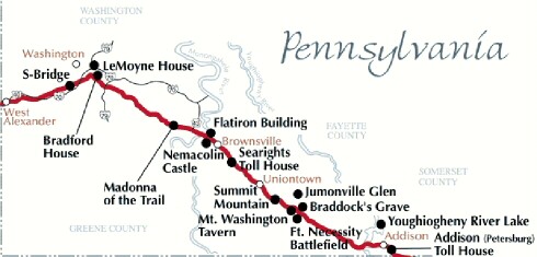
National Road
National Road
Another of the more famous roads, US 40 follows the same path as the National Road. The National Road was created by the United States government under the advisement of President Thomas Jefferson in 1806 to provide a route from the settled eastern seaboard into the central part of the country to open up the Midwest for settlement. It was the first Federally-funded interstate highway which ran from Baltimore, Maryland to Vandalia, Illinois.
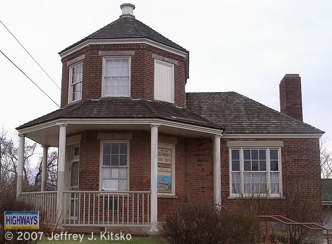
Searight's Tollhouse was one of numerous collection points for tolls.
Originally, US 40 spanned the country from Atlantic City, New Jersey to San Francisco, California. With the advent of the Interstate system, the route was truncated to Park City, Utah and its remaining length to the "City by the Bay" was supplanted by Interstate 80.
As for the history of US 40 in Pennsylvania, the route remains the same outside of the cities of Uniontown and Washington. In Washington, the route followed Chestnut Street, College Street for eastbound traffic, Lincoln Street for westbound traffic, and Maiden Street. In Uniontown, the designation followed Main Street and Fayette Street.
The first change in the routing took place in 1938, when the designation was moved to Chestnut Street and Main Street in Washington. In 1939, the highway was widened from Washington to Pancake which is now known as Laboratory.
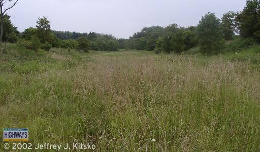
The 1940s came with more work done to improve the highway with widening projects taking place from Elwood Park to Washington, Beallsville to Suzy Lane, New Salem Road to Uniontown, Beaver Creek Road to Elk Park, and Addison to the Maryland state line in the first year of the decade. The following year the section from Elk Park to PA 281 south was widened. In 1946, the highway was widened from McKee Road to Elwood Park, Hopwood to Wharton Furnace Road, and Lakeside Road to Newberry Road. In 1948, the new Youghiogheny Reservoir Bridge opened to traffic. The former alignment can still be seen when the level of the lake is low. One aspect that can be seen is the National Road bridge that crossed the river at the village of Somerfield, which was demolished to make way for the lake. Widening of the alignment took place from PA 281 south to the bridge and from there to Lakeside Road.
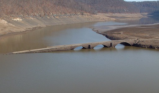
Old National Road bridge re-emerges during a dry spell. (Vince Ferrari)
Widening work continued into the 1950s with the section from Wilkins Hollow Road to Addison being completed in 1950. In 1958, a median was installed at the intersection with New Salem Road and from PA 281 north to Mud Pike. That year the route changed course in Washington to follow Maiden Street, Franklin Street, Beau Street, and Jefferson Street and replace "THRU US 40."
The 1960s saw construction beginning on the first section of expressway for US 40 from Daisytown Road to Market Street in 1962. The following year, this section which also included the Lane Bane Bridge over the Monongahela River opened. The designation was removed from National Pike, Bridge Street, and High Street. Construction began in 1968 on the section from Broadway Street to PA 166 which opened the following year but did not receive the US 40 designation for another two years. Also opening in 1969 was the new alignment between Beau Street and Franklin Street in Washington, which included widening and installing a median on Jefferson Avenue between Chestnut Street and Beau Street.
In 1972, a median was installed from Hopwood to Wharton Furnace Road. An odd occurrence took place in 1975, when the southern Uniontown bypass was shown on the PennDOT map as being under construction. However, two years later it was removed from the map.
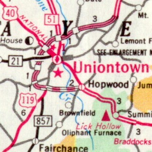
Proposed Uniontown Bypass in 1976.
(PennDOT)
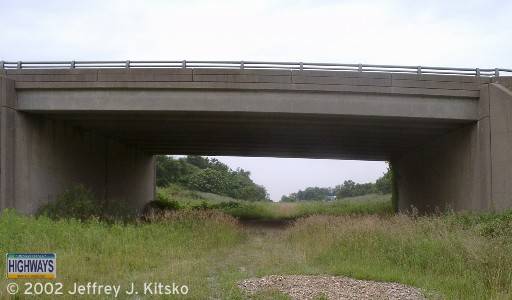
It would not be until October 22, 1990 when construction would actually begin on this section. That day a groundbreaking ceremony, with Governor Robert Casey in attendance, was held for the 3.5-mile-long section between US 119 and Business US 40 as well as the 3.5-mile-long Chadville Demonstration Project which is part of the Mon-Fayette Expressway. In 1994, the $22 million southern bypass opened and received the US 40 designation which was removed from West Main Street, East Main Street, and Fayette Street through downtown Uniontown and Hopwood.
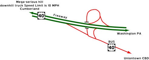
The end of the southern bypass east of
Uniontown. (C. C. Slater)
There are efforts underway to get US 40 designated a federal All-American Road, which would mean millions of dollars to develop tourism along the highway. There are problems that have arisen with all of this good news. The National Road Heritage Park Commission, who does most of the paperwork, lacks elements of leadership such as an executive director. PennDOT District 12 Engineer Michael Duffalla has cautioned other board members to proceed slowly, fearing that this designation would delay or block improvements. If the highway gets the federal designation, it could mean advertising and marketing the highway across the country and be used as leverage to gain federal, state, and private development dollars. Some of the highways currently designated All-American Roads are the Pacific Coast Highway in California, the San Juan Skyway in Colorado, and the highway taken by civil rights marchers from Birmingham to Montgomery, Alabama.
On June 13, 2002, United States Transportation Secretary Norman Y. Mineta announced that US 40 in Pennsylvania, along with 12 others across the country, became All-American Roads and 23 National Scenic Byways were added to the list of America's Byways. The designation gives the National Road Heritage Park access to new grants. Transportation Secretary Allen D. Biehler along with other state and local officials, cut a ceremonial ribbon on May 8, 2003, to officially mark the National Road as a National Scenic Byway "All-American Road." Donna Holdorf, executive director of the National Road Heritage Corridor, said the designation will give her organization about $24 million to promote tourism to the area. The ceremony was held on the "S" Bridge in Buffalo Township in Washington County.
Construction on a new bridge across the Youghiogheny Reservoir began on October 6, 2003. The $25,380,707.71 project entailed building a new, eight span, 1,730 foot-long bridge north of the former one and then demolishing the former span. The project concluded on October 7, 2005 when the bridge officially opened to traffic but paving the approaches did not finish until May 2006.
After having sat idle for 39 years, the expressway stub east of Brownsville ceased to be on December 5, 2007. Prior to that date, traffic had to exit/enter and negotiate a traffic signal at PA 166. The new alignment, which was built as part of the Mon-Fayette Expressway project and will provide access to one of PA Turnpike 43's interchanges, is three lanes built on a five lane alignment with one being a center turning lane because Redstone Township would like to develop that area. The contract for construction was awarded on June 6, 2006 to New Enterprise Stone & Lime Company of New Enterprise, Pennsylvania for $33,503,565.
|
|
|
|
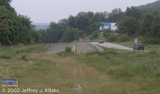 Facing westbound towards Brownsville on what was originally built as part of the Mon Valley Expressway project in the late 1960s. |
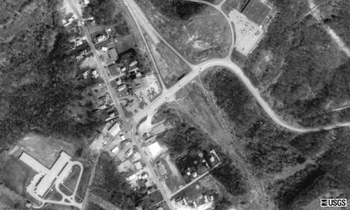 Aerial picture of the former stub at Redstone Way. |
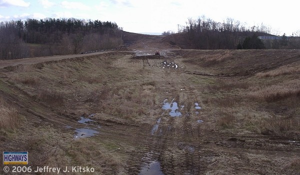 Facing eastward at the stub of the US 40 expressway east of Brownsville where grading was taking place for the Brownsville Connector in December 2006. |
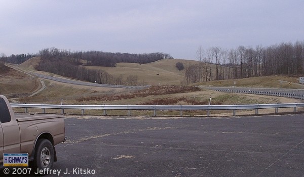 The US 40 connector facing Brownsville from the future PA Turnpike 43 interchange. |
A segment of National Road history was discovered in August 2008 during construction of the Mon-Fayette Expressway near Brownsville. During excavation for a bridge near the Brownsville Drive-In, workers unearthed an intact slab of former pavement. As part of an agreement with the Pennsylvania Turnpike Commission, the National Road Heritage Corridor was contacted about the find. The cube-like slab, comprised of soil, crushed limestone, asphalt, and pavement, was the first piece of the National Road ever to be removed intact, said National Road Heritage Corridor Executive Director Donna Holdorf. Workers from Golden Triangle Construction Company, the contractors working on the expressway, helped to crate and transport the slab to storage and eventual display at Fort Necessity. The multi-layered, four-foot-deep piece will help transportation scholars understand the history of the road. "The slab of stratigraphy reveals, in a small way, the complete history of the National Road," said Ryan Rowles, regional archaeologist for PennDOT. "It's a window into the history of transportation in our region."
A landslide which brought down trees and debris shortly before 9 PM on June 24, 2021 closed the National Road at the Fayette/Somerset County line. The road was closed between PA 281 and the latter point along the route. Crews had to clear tens of millions of pounds of debris before the hill could be stabilized. "When you see the size of the hill, the amount of dirt we still have, it makes you realize the scope of this problem," said Jay Ofsanik with PennDOT. The hard winter and very wet spring led to the landslide, which can happen, but nothing on this scale was anticipated. "We're estimating about 900 truckloads, 10 to 12 cubic yards a truck," said Ofsanik. Work to remove the debris and stabilize the hillside continued for over a month with the road reopening at 1:30 PM on August 13.
| National Road
Heritage Corridor
The National Road Heritage Park is one of nine special heritage areas in the Commonwealth of Pennsylvania. Each is a nonprofit organization designated by Governor Tom Ridge. The park consists of Washington, Fayette, and Somerset Counties, using the historic National Road as a uniting element for preserving scenic, cultural, and historic resources, as well as restoring and developing existing and new programs and facilities.
Website: https://nationalroadpa.org |
Links:
Exit Guide
US 40 Auxiliary Routes
US 40 Pictures
PA
Turnpike 43
Historic National Road - visitPA
The National Road
- National Park Service
The
National Road: A Photo Essay - Adam Prince
Route 40-National Road - Frank Brusca
Terminus
of US 40 - Dale Sanderson
US 40
Pictures - Steve Alpert
 INFORMATION
 |
| Western Entrance: |
West Virginia state line one-half mile west of West Alexander. |
| Eastern Entrance: |
Maryland state line three miles east of Addison. |
| Length: | 83 miles |
| National Highway System: |
Business US 40 to Chadville |
| Names: | National Road Main Street, Chestnut Street Extension, Jefferson Avenue, Maiden Street, Market Street, Grindstone Road, and George C. Marshall Parkway |
| SR Designations: |
0040 0019: Washington to Laboratory |
| Counties: | Washington, Fayette and Somerset |
| Expressway: |
Brownsville to PA 166 Business US 40/US 119 to Hopwood |
| Multiplexed Routes: |
PA 231: Claysville PA 18: Washington US 19: Washington to Laboratory PA 88: PA Turnpike 43 to West Brownsville US 119: Business US 40 to Chadville PA 381: Farmington PA 281: one mile east of Elk Park |
| Former Designations: |
PA 11 (1925 - 1926):
West Virginia state line to Beau Street; Franklin Street to Daisytown
Road;
PA 166 to US 119; Business
US 40 to the Maryland state line PA 81 (1926 - 1930): West Virginia state line to Beau Street; Franklin Street to Daisytown Road; PA 166 to US 119; Business US 40 to the Maryland state line Alternate US 40 (1938 - 1948): West Chestnut Street to Beau Street and Franklin Street to Main Street in Washington THRU US 40 (1948 - 1958): West Chestnut Street to Beau Street and Franklin Street to Main Street in Washington |
BicyclePA Route: |
West Virginia state line to Lincoln Hill |
 Laurel Highlands Scenic Byway: |
PA 381 to PA 381 in Farmington |
 Pennsylvania Byway: |
West Virginia state line to US
119 Business US 40 to the Maryland state line |
 Washington's Trail: |
US 119 to the Maryland state line |