At today’s car show at the Sideling Hill Service Plaza, not only did I receive a lot of Turnpike “swag,” but included in the “goodie” bag that all participants received was a copy of the new 2013 official Turnpike map.
It is the same size as the 2011 version, but instead of being a tri-fold map, this year’s version features an “accordion” fold. The following are changes since the 2011 edition:
Carbon County
E-ZPass-only interchange on Interstate 476/Pennsylvania Turnpike-Northeast Extension at PA 903 marked as under construction

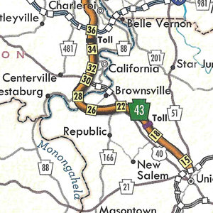
Fayette County/Washington County
PA Turnpike 43 open between US 40 and PA 88
The cover features a picture of the mainline Turnpike between the Blue Mountain and Carlisle interchanges. You may view the strip maps of the 2013 official Turnpike map at the Pennsylvania Turnpike Commission’s page.