Categories
Events News

Winter 2007 SWPA Meet

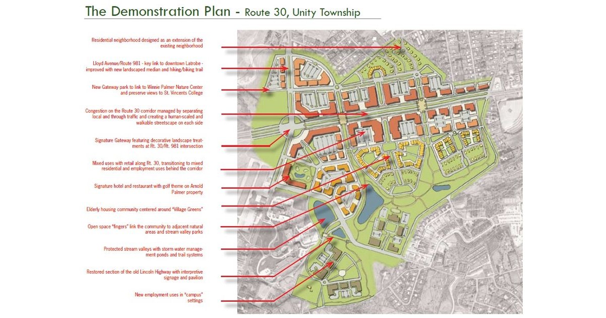
Saturday was the latest edition of the longest running road enthusiast meets. I’d like to thank all who traveled both near and far to attend the Winter 2007 SWPA Meet.

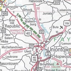
The meet began at 12 PM at Garfield’s in the Uniontown Mall on US 40 near the US 119 interchange.  The food and conversation was excellent as always.  I provided each attendee with a copy of the 2007 PennDOT map.

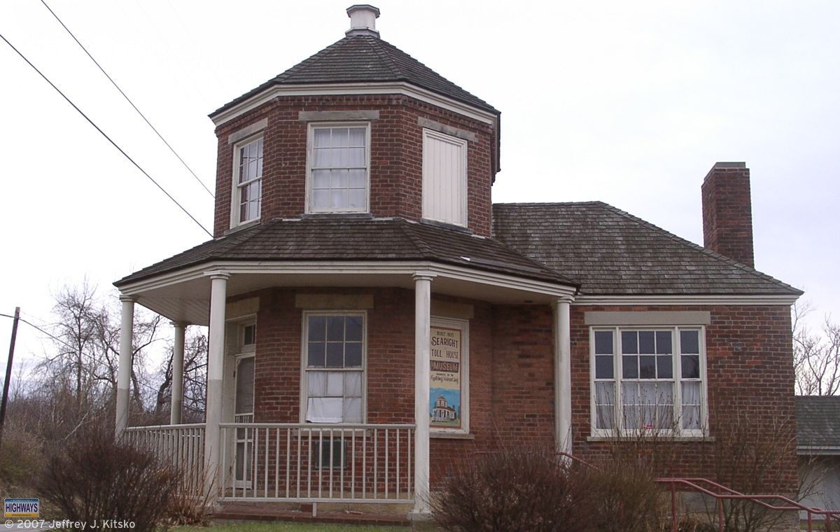
After the lunch portion, we headed down US 40 to see the new Brownsville Connector.  We decided to make the Searights Toll House the first stop, and it’s best that we did.  I noticed that one of the windows appeared to be open.  Upon further examination, it wasn’t open. Rather, someone had taken one of the bricks from the steps and smashed the window.  In addition, there were rips and pulls in several places in the screen on the screen door at the entrance.  After calling 911, they informed me that the police would investigate and the proprietors would be notified.

Searights Toll House was one of the stops during the Winter 2007 SWPA Meet.
Searights Toll House

The next stop was to see the new US 40 connector that just opened east of Brownsville.  What struck the attendees of the 2006 gathering was the former partially constructed interchange just north of PA 166, where US 40 traffic would turn to continue, has been replaced with an at-grade intersection.  Even though last year, we noticed grading for what appeared to be the other entrance/exit ramps had taken place, which is noted on the US 40 page.  Also, PA 166’s northern terminus has not moved to intersect the new US 40 alignment. The route still ends at the former intersection, a block to the south.  Grading at the future PA Turnpike 43 interchange, which is currently a temporary end until the loop around Brownsville opens, is complete.

On the way back to Uniontown, we took a small detour over a new connector road built between PA 51 and US 40. It will serve an interchange of PA Turnpike 43 and is five lanes wide (four travel lanes and a center turn lane). This roadway is located through the area where I attended the groundbreaking for the Uniontown/Brownsville section.

We took PA 43/PA Turnpike 43 south and stopped at the current end at Gans Road. Afterwards, we continued south into West Virginia to see how they are progressing on their section.  From PA 857/WV Secondary 857, it is possible to see the bridge on the state line is complete. It includes a “Welcome to West Virginia” sign gantry.  Turning off onto Morgan’s Run Road, we had an up-close look at another pair of spans taking shape and saw a completed section of WV 43 with signage already installed.  Back at 857 we continued south to the Cheat Lake interchange. There we saw the construction taking place in preparation of the directional “T” interchange between Interstate 68 and WV 43.

After turning around, we headed back to Garfield’s. There we said our goodbyes, Merry Christmases, Happy New Years, and headed to our respective destinations after the Winter 2007 SWPA Meet.

Share this:
Categories
Events News

Planning For the Future

One of the things that we’re not that good about in Pennsylvania is planning for the future.  Tonight, myself and others in my area decided to do something about that.  Smart Growth Partnership of Westmoreland County has been holding a public Charrette this week at the University of Pittsburgh at Greensburg.

Planning for the future of the US 30 corridor south of Latrobe.
The imagined US 30 corridor south of Latrobe

We were placed in groups and asked to evaluate different plans for the area of US 30 in Unity Township outside Latrobe.  The first plan would create almost another town along 30 from PA 981 to PA 982. No one liked this one because the minimum building height would be six stories.  Obviously this would destroy the views of the Laurel Ridge and trying to keep the area rural.  The second plan would be to keep more of the area in a rural setting, but enhance the existing developments along the corridor.  The third plan would be a “Greenway” solution, where most of the businesses would be removed and more of the area returned to a natural state.

While most seemed to prefer the latter, I was in favor of the second plan.  The first plan and last plan would eliminate the shopping areas of Latrobe 30 Plaza, Mountain Laurel Plaza, Wildcat Commons, and Unity Plaza. Stores such as Giant Eagle and Wal*Mart would go away.  I highly doubt Wal*Mart will have gone the way of Montgomery Ward by the year 2020.  Although people probably said the same about Wards in 1980 so who knows.

Planning for the future traffic growth, I proposed the idea of completely bypassing current US 30 with an expressway. This would remove the through traffic from the highway and create a Business US 30 on the current alignment.  Actually, not my idea, but the “Route 30 Relocation” proposal from the Pittsburgh Area Transportation Plan devised in the 1960s.  The same thing happened between Sadsburyville and Exton. The current alignment of 30 is an expressway and the original alignment is a business route.  Then a redesign could take place of any area along the corridor without having to contend with as much traffic.  However, my idea did not garner any approval.  Oh well, so much for trying to undo past mistakes.

Route 30 Masterplan – Smart Growth

Share this:
Categories
Announcements News

2007 Official Road Map

Last month, I received a copy of the 2007 official road map from the Department of Transportation’s Map Sales office. I was fortunate to be able to receive it just before the state shut down due to not being able to pass a budget.  Here are the changes since the 2006 edition:

Allegheny County/Washington County/Pittsburgh inset:
PA Turnpike 576 completed and open to traffic between US 22 and PA 60

PA Turnpike 576 completed on the 2007 official road map.

Berks County:
US 222 completed and now indicated with the red “expressway stripe” between PA 272 and Shillington

US 222 completed on the 2007 official road map.

Fayette County:
PA Turnpike 43 shown as under construction north of US 40 from US 119 to Brier Hill

PA Turnpike 43 under construction on the 2007 official road map.

Tioga County:
US 15 shown as under construction from PA 49 to the New York state line

US 15 under construction on the 2007 official road map.

Altoona inset:
Osgood Drive completed on the eastern side of I-99/US 220 between Exit 32 and Exit 33

Osgood Drive completed in Altoona on the 2007 official road map.

New Castle inset:
PA 65 extended from Business US 422 to end at PA 108/PA 168

PA 65 extended in New Castle on the 2007 official road map.

The map has the same dimensions as the previous year’s. However, this year’s cover is from America’s Most Livable City, Pittsburgh, with a man creating a mural in chalk on the West End overlook. You can view the 2007 official road map at Department of Transportation’s Graphical Information System page.

Cover of first version of the 2007 official road map.
Share this:
Categories
General

Roads on Television

I’ve always had an interest in broadcasting. It began by building a small AM radio station with a Radio Shack 130-in-one Project Kit. Then it extended to college where I studied Communication. So it comes as no surprise my interest in media would overlap with roads.

The advent of digital TV has opened up the world of multicasting to broadcasters. Many are utilizing their new bandwidth for other programming in addition to their main channel.  PBS affiliates are airing other PBS-branded channels such as Create. Other affiliates, such as WQED, have created local channels. Their Neighborhood Channel airs a lot of Rick Sebak’s Pittsburgh documentaries from their library. NBC affiliates are co-branding the NBC Weather Plus channel for their local markets.

WTAE-TV launched their Weather & Traffic Watch 4 channel in the Spring utilizing AccuWeather content. Since I have an interest in roads as well as weather, this channel sounded like something to check out. Traffic.com information is in a crawl at the bottom of the video portion of the screen. Sometimes video from PennDOT traffic cameras will be shown from various points, such as Interstate 376 seen below.

Screenshot of WTAE-TV's Weather & Traffic Watch 4 channel with roads on television.
WTAE-TV’s Weather & Traffic Watch 4

This made WPXI-TV kick it up a notch. They are now providing traffic information during the local inserts on their Weather Plus channel.  The difference is that they use Traffic.com’s flow maps to show traffic conditions instead of a continual text crawl.

Screenshot of WPXI-TV's Weather Plus channel with roads on television.
WPXI Weather Plus

Even The Weather Channel now provides traffic information during their “Local on the 8’s” segment. Sorry DIRECTV and DISH subscribers, but it’s only on cable.

The new IntelliStar systems feed information during those segments on the main channel and all day on their Weatherscan channel.

Screenshot of with roads on television during The Weather Channel's "Local on the 8's" segment.
The Weather Channel

The idea of roads on television is not a new one. San Antonio, Texas has had a low-power TV station owned by TxDOT airing traffic camera feeds since 1996.

Share this:
Categories
Announcements News

Get Your Kicks on Route 76…276…476

The first major snow and ice storm of the year has hit the Commonwealth. Highway travel across the state was hampered from its wrath. Due to the severity of the storm and its impact, the Turnpike Commission has suspended toll collection on its roadways. So you can get your kicks on route 76…276…476.

Snow cover across the state which led to get your kicks on route 76, 276, 476.
Snow cover across the state (NOAA)

Sections of Interstate 80 and Interstate 81 have had to close due to stranded vehicles. This has led to the inability for PennDOT plow trucks to clear the roadway. However, the worst back-up took place on Interstate 78 which stretched for about 50 miles from Interstate 81 in Lebanon County to PA 100 in Lehigh County. Numerous tractor-trailers began spinning out and jack-knifing trying to ascend a hill on the Interstate near Hamburg. What started out as snow had changed to ice, which led to the poor conditions. Around 9 PM on Valentine’s Day, the National Guard began using Humvees to deliver food, blankets, and baby supplies to those trapped in the gridlock.

PennDOT began to close down sections of those Interstates this morning to clear the vehicles as well as the snow and ice.  The problem was that motorists were still able to enter the highways at various points.  That just added to the existing problem.

With the amount of time it will take PennDOT crews to clean up the scenes and get the Interstates back in shape for traffic, they are asking cross-state traffic to use the Turnpike’s mainline and Northeast Extension as alternate routes.

Governor Rendell has declared a statewide Disaster Emergency. As part of that declaration, tolls are waived on the Turnpike. This is the first time since the first day of the collector strike in 2004. So if you are crossing the state, you can get your kicks on route 76…276…476.

Toll Waiving – Disaster Emergency – Pennsylvania Turnpike Commission

Share this:
Categories
News

Winter Storm Wreaks Havoc

From North to South and East to West, there was no hiding from the wrath of Mother Nature the past two days.  Whatever your mode of transportation was, it was either slowed or outright stopped as the first major storm of 2007 made its trek towards the Atlantic.  The worst of the storm hit the eastern side of the state. Interstate 78 was at a stand-still for most of Valentine’s Day. However, all parts of Pennsylvania felt the brunt of this storm. The following is a round-up of road-related stories from all points inside the Keystone State when a winter storm wreaks havoc.

Northwest
Keeping Snow Away from the Street – WICU-TV Erie
Snowy Side Streets Trap Drivers, Towing Warning – WJET-TV Erie

Northeast
Roads Called “Horrible” – WNEP-TV Scranton
Interstates Closed for Icy Conditions – WNEP-TV Scranton
Storm Brings Mixed Bag – Williamsport Sun-Gazette

Southeast
Colossal Traffic Mess Strands Motorists For Hours – KYW-TV Philadelphia
Logjam Gone, But I-78 Closed – WPVI-TV Philadelphia
Hundreds Stranded on Interstate 78 – WHTM-TV Harrisburg

Southwest
Valentine’s Day Storm Causes Treacherous Commute – WTAE-TV Pittsburgh
Local Woman’s Frightening Ordeal On I-78 Ends – KDKA-TV Pittsburgh
Crash in Snow Causes I-79 Closure – WPXI-TV Pittsburgh
Rendell Declares State of Emergency – Pittsburgh Post-Gazette

The snow cover after a winter storm wreaks havoc in 2007.
Snow cover across the state (NOAA)

Where I live east of Pittsburgh, or “ice-burgh” as it was referred to in the media, we received about seven inches. Certainly, it would have been more if the precipitation did not turn from snow to freezing rain through Wednesday morning.  When I checked my e-mail this morning, there were almost 130 travel bulletins from the PTC and PennDOT!  Public transportation was not a choice either, as the subway, also known as the “T,” was not running through the South Hills. The reason for the closure of the subway was due to ice on the overhead wires.

This winter storm is now winding down. Needless to say, this will not be the last time a winter storm wreaks havoc.

Share this:
Advertisements