Today, I stopped by my local DMV to get my driver’s license renewed. It was an uneventful process. That probably had to do with the fact that there had been an icing event that morning and no one was out traveling as they were usually after Christmas. As I waited for the new one to finish laminating, I happen to notice down at the other end of the counter, stacks of state maps. So, I picked up a copy of the 2012 official road map. I guess better late than never that I was able to secure a copy right under the wire. No idea why the Department of Transportation and VisitPA decided to print another in succession, since there is only one change.
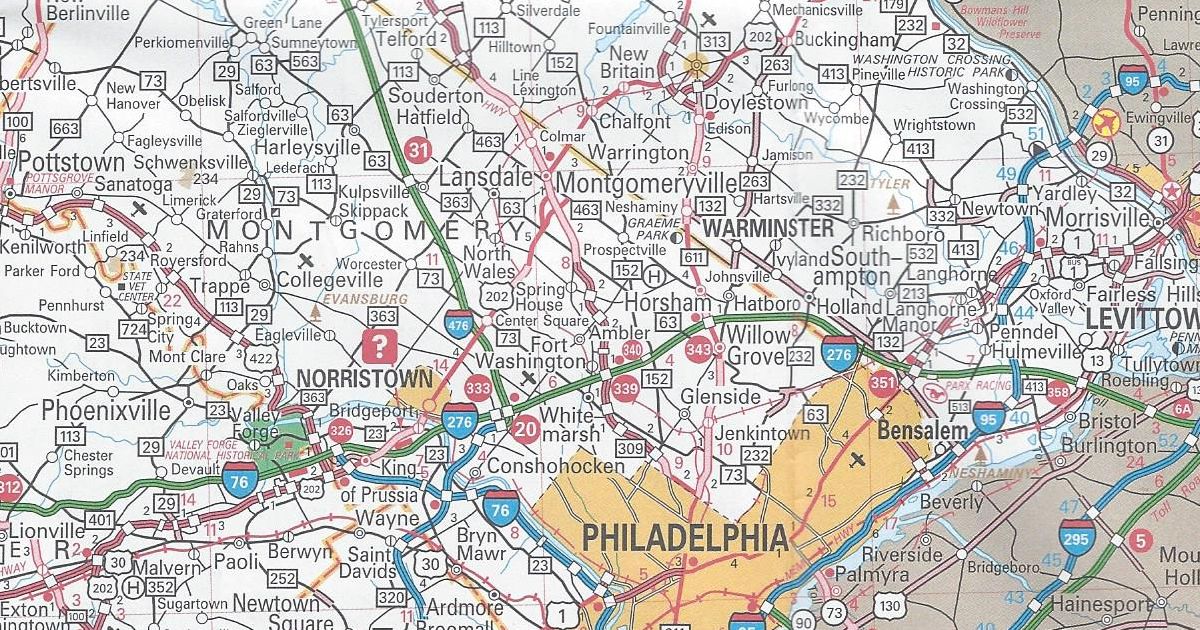
Montgomery County US 202 Parkway shown as completed from US 202 to PA 463
The parkway is a “consolation prize” for the lack of a full expressway. Planning for, which took place in the 1960s and 1970s as the Piedmont Expressway. Rather than build an expressway, the new roadway is and will be an at-grade facility with separated trails for biking and walking along the route. This was the more favorable plan for the communities along the new US 202 alignment.
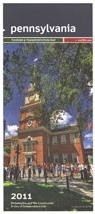
That is the only change to the 2012 official road map. It has the same dimensions as the previous year’s map. However, this year’s cover features a picture of a man kayaking on the north branch of the Susquehanna Water Trail.
You might have heard of the website Pinterest, or at the very least, seen “Pin It” icons on sites you have visited. It is another social media websites like Facebook and Twitter, but not about sharing statuses or links to Icanhascheezburger, but sharing pictures. People use Pinterest to plan weddings, pick out a place to visit for their next vacation, and design a new living room by posting pictures they find to “boards” on their page.
Businesses are also joining in on the fun of sharing. The Department of Tourism, VisitPA, has a page that shares pictures from around the state of points of interest and scenes of natures. Today, Pennsylvania Highways has joined to share pictures relating to the highway system of the Commonwealth as well things relating to highway travel. The best part is, there is nothing sharp involved.
One of the things I like about working on this website is showing and explaining how the highway system of Pennsylvania has evolved over the years. Now I am taking the show on the road…literally.
So on March 11, I am taking this website and crunching it down to an hour-long presentation entitled Pennsylvania’s Roadways: From the Lincoln to Eisenhower. It will be Sunday, March 11 beginning at 2 PM at the Lincoln Highway Experience, the headquarters for the Lincoln Highway Heritage Corridor, at 3435 Route 30 East (a.k.a. the Lincoln Highway) in Latrobe. Refreshments will be provided.
Due to limited seating in the auditorium, advanced reservations are required, which can be made through the LHHC’s website or by calling 724-879-4241. Admission is $10/person for non-LHHC members and $7/person for Friends of the Lincoln Highway.
Today I received an order from PennDOT which included a copy of the 2011 official road map. It is not surprising PennDOT went to the trouble of printing one, since we elected a new Governor last year and therefore have a new Secretary of Transportation. These are the changes since the 2010 edition:
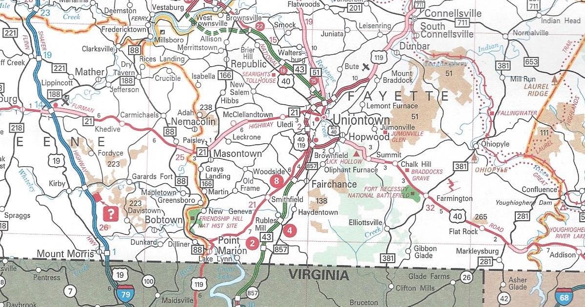
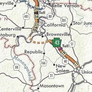
Fayette County PA Turnpike 43 completed from West Virginia to Exit 2 and the US 119/PA 51 interchange to Exit 15
Indiana County US 22 is now a four-lane, divided highway from just east of Blairsville to Armagh
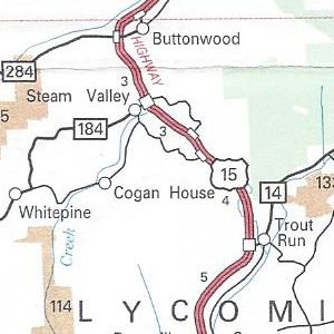
Lycoming County US 15 upgraded to an expressway from north of PA 14 to PA 184
Pittsburgh enlargement Consol Energy Center shown
Erie enlargement PA 299 removed from Powell Avenue
Philadelphia enlargement Street Road E-ZPass-only slip ramp completed
Those are all the changes to the 2011 official road map. For most of the URLs on the map, there is a likewise corresponding Microsoft Tag to scan with a smartphone. However, the link for VisitPA uses a regular QR Code.
No longer appearing on the map is the yellow shading of “Selected Built Up Areas.” Meanwhile, the dark, shaded areas of urban concentrations remain. State Game Lands have changed from a peach coloring to a tan one. The State Park textured color used to indicate the extent of said park has been removed, but it remains in the city insets.
Above all, the US 22/US 322 shield error on the 2010 map on the Penn-Lincoln Parkway at PA 60 is now the correct US 22/US 30 shield. There is now an inset for the Elk Scenic Drive in the upper left corner over Lake Erie. A yellow highlight instead of an orange one indicates its path on the main map.
It has the same dimensions as the previous year’s map. However, this year’s cover features a picture of Independence Hall.
After the 65th Little League World Series champion was crowned last month, the first Williamsport Road Enthusiast Meet was held this month, specifically today. I’d like to thank all who attended and for making the trip for the 2011 Williamsport Meet, the first meet in north central Pennsylvania.
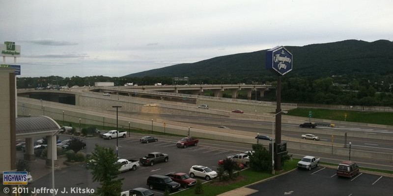
The newly refurbished Market Street Bridge and newly built Single Point Diamond Interchange in Williamsport. Prior to construction of the interchange, US 15 exited farther south (or to the right of the picture) onto a then four-lane Via Bella to connect to the bridge. Now that street is two lanes with roundabouts at various intersections. It is expected that US 15 will be truncated here when Interstate 99 is signed north to New York.
The meet began as usual at 12 PM at the Bullfrog Brewery in downtown Williamsport. The food was good as well as the conversations. Mike Pruett brought some Maryland official highway maps and I brought copies of the new Turnpike System map as well as some old copies of the Pennsylvania official highway map for everyone.
After lunch, we hopped in our cars and followed US 15 to see the improvements made to the corridor over the past decade in order for it to be designated Interstate 99. There are numerous signs along the way denoting it as the “Future I-99 Corridor.”
The first stop of the 2011 Williamsport Meet was at the Cogan House interchange, just north of the PA 14 interchange. What is interesting about this particular interchange is that the road that connects the two directions of US 15 are the original southbound lanes. They needed to be replaced due to sharp curves at the bottom of the Steam Valley hill, but the section here was retained and turned into an interchange for Cogan House.
We continued north to the next stop, at the next interchange, at PA 184 in Steam Valley. Prior to 2010, this was an at-grade intersection, but of course had to be upgraded to an interchange for the Interstate 99 designation to be applied. In order to create the junction, the right-of-ways of both US 15 and PA 184 were changed. As I mentioned above, the existing southbound lanes could not be used, so the new ones were shifted eastward and the alignment of PA 184 was shifted southward. An interesting anomaly was created in that PA 184 technically doesn’t end at US 15, but rather just to the east of the diamond interchange at Steam Mill Road.
I asked the group if they wanted to clinch US 15 from Williamsport to the New York state line, and everyone agreed we might as well since we were that far north. Crossing into New York, the roadway narrows down to two lanes through an interesting temporary interchange with very modern-looking light poles to illuminate the path. We made the first right to head back into Pennsylvania onto a road that connects to the old route of US 15 now known as Steuben County Route 115. Once in Lawrenceville, a few continued onto PA 287, which was extended northward after the expressway was completed to the west, and the rest onto PA 49 to head south on US 15.
The final stop of the 2011 Williamsport Meet tour was the beautiful Tioga Welcome Center, just south of the PA 287 interchange, which overlooks the Tioga Reservoir. Many have compared the recent flooding in the northern part of the state to that seen in the wake of Hurricane Agnes in 1972. That event was the impetus for construction of the reservoir, as the Allegheny Reservoir demonstrated the need by saving western Pennsylvania the destruction seen in the eastern part of the state.
I showed the group the original path below of US 15 through Tioga and how it’s alignment is now underwater. Everyone was able to pick up brochures and maps. Not only the 2010 official state one, but also the 2008 Trucker’s Guide to Pennsylvania. It is a black-and-white version of the regular map. However, the only colors on it denote the various truck routes. Also included is specific information for “gear jockeys” such as low clearance points and locations of steep grades. After taking the group picture there with the spectacular backdrop, we said our farewells, and headed to our respective destinations.
I decided to set off on my literary journey of The Big Roads with an open mind and my Pennsylvania Turnpike bookmark. It seemed fitting considering I was reading a book about the Interstate System, and the Turnpike was one of the earliest segments of it that was completed.
When I say “an open mind” it is because I was a bit skeptical approaching reading this book. The reason being is there are many in the Pennsylvania Highways Library on the history of the Interstates. However, in the Introduction, author Earl Swift hooked me with his description of the trip across the country which he took to research The Big Roads. As part of that trip, he came through the southern portion of the Commonwealth on the historic Lincoln Highway. Earl, his daughter, and a friend of hers stayed on the Lincoln through Buckstown to Ligonier and eventually onto Pittsburgh, “…crawling from one stoplight to the next…” Unfortunately, that is a realistic description of travel down US 30 through Westmoreland and Allegheny counties!
The book takes readers on a journey, with a focus on persons who made the transition happen. Starting with Carl Fisher, a businessman in Indianapolis, who began his career selling bicycles. He then moved onto the “horseless carriage.” To demonstrate the power of the car, he built a racetrack outside Indianapolis. Once it was repaved with brick, the power of the automobile could be exhibited in the way he intended. He also got into the road-building business by backing the creation of the Lincoln Highway and its north-south counterpart, the Dixie Highway.
Along the way, author Swift introduces us to Thomas Harris MacDonald. Mr. MacDonald started his career in roads in Iowa by laying out their system. Then the Feds tapped him to do the same on a national scale. We also meet Dwight D. Eisenhower, who in 1919 as a young Army officer, got a yearning for good roads after a cross-country trip on the Lincoln Highway. Just under three decades later, he would experience superb roads — just not on this continent.
The one good road, whose idea and planning came from those Ike saw in Germany which were the forerunner of the Interstate System, was our very own Pennsylvania Turnpike. Just as safety was an impetus for the construction of the Interstates, the Turnpike was constructed to provide a safer alternative than the windy, mountainous, and narrow US 30. That was the primary route between Pittsburgh and the Mid-State area at the time.
Once Eisenhower got into the White House, he pushed for the need for high-speed, limited-access highways. He had seen the Autobahn used by his military to speed across Germany en route to Berlin. He did not need to look far for ideas. The Bureau of Public Roads had drawn up plans for such expressways; albeit tolled, while Ike was the Supreme Commander in World War II.
“The more things change, the more they stay the same” is a saying that often rings true. When talking about the debate Congress had over the Federal Aid Highway Act, it rings like Big Ben at high noon. Some legislators came out in favor of the plan. Others like Senator Albert Gore, the inventor of the Internet’s father, argued that it “…could lead the country to inflationary ruin.” Senator Harry Byrd said that “…nothing has been proposed during my twenty-two years in the United States Senate that would do more to wreck our fiscal budget system.” I’d hate to see what the “talking heads” on CNN, MSNBC, and Fox News would have said had those channels existed at the time.
The Big Roads is not just a reflection on how the highway system of the country changed, but how the country itself changed. The Interstates allowed the movement of goods and people in a short amount of time. They did so safely without the worry of cross-streets, traffic signals, stop signs, or rail crossings. These limited-access roadways all but eliminated head-on accidents in a uniform, monotonous drive devoid of local flavor. They also allowed for the growth of cities by pushing the suburbs farther out. This helped in the creation of satellite cities along beltways and bypasses. However, their paths into and through the cities would be a double-edged sword.
As I said in the beginning, I have other books on the Interstates and wondered how this book would differ. My answer would come in the final chapters of the book. The Federal Aid Highway Act of 1956 came into being just before the tumultuous 1960s. It was this period when the struggle for civil rights would reach its pinnacle. Urban Interstate routes were once seen as a way to rejuvenate the nation’s cities. At the same time, they were clearing out undesirable sections. The problem was that those undesirable sections contained people. They did not want to lose their homes just so suburbanites could get downtown quicker.
One such person was a man by the name of Joe Wiles. Mr. Wiles lived in the Rosemont section of Baltimore, which was under attack by Interstate 70. Mr. Wiles led a revolt against construction of I-70, which was both successful and unsuccessful. His revolt had been initially successful when its planned route through the City of Baltimore cancelled. However, it was also unsuccessful because discussions of the impending expressway doomed Rosemont to neglect. Ironically, it had become the type of area that would be favorable as an Interstate corridor.
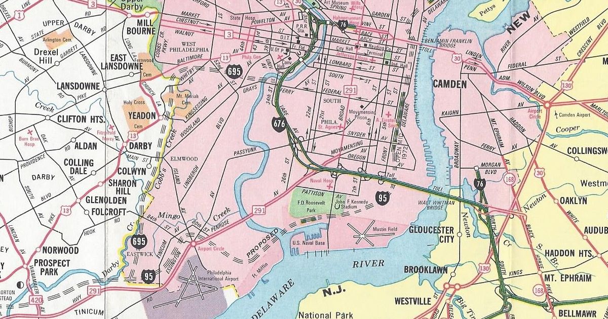
Black neighborhoods seemed to be under attack across the country. From Nashville where Interstate 40 was planned to isolate about 100 blocks from the City, to here in Pennsylvania where Interstate 695 in Philadelphia, known as the Crosstown Expressway, was to sequester black neighborhoods from Center City. These seemed like classic examples of white men’s roads going through black men’s homes.
Interstate 695 between the Schuylkill Expressway through South Philadelphia to Interstate 95 would have been the Crosstown Expressway. The segment shown on the map was proposed as the Cobbs Creek Expressway.
Those other books in the Library only talk about the positive aspects of the Interstates. They hardly discuss the turmoil they caused as they carved their way across the country. I admire that Mr. Swift mentioned the issues of the urban routes through Baltimore, for example. When I write about the history of a route, I, too, mention the negatives in addition to the positives. I am glad to see a publication which does the same.
In conclusion, I would recommend The Big Roads. It is a well-rounded look at how we have progressed from roads that were narrow, dirt paths to today’s wide, concrete expressways. It makes for a good read, especially stuck in traffic on one of the Interstates.
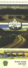
Today, the ribbon-cutting event for the latest section of Mon-Fayette Expressway occurred. Not only did I pick up several free bottles of water compliments of the Turnpike Commission, I picked up something I haven’t seen in years: a new 2011 official Turnpike map.
The PTC’s “belt-tightening” in recent years led to them not printing a map. It is evident by looking at this one, as it is much smaller than its 2004 ancestor. The reason for this change is in a note below the legend:
To conserve natural and fiscal resources, our Travel Guide and Map is half the size of earlier editions. The new size also responds to a shift in how travelers — in an age of online maps and GPS devices — use printed maps today.
In addition, the map is not a PennDOT official. The Turnpike System is not highlighted in green, with a white-on-green Keystone shield denoting the route number. That was the standard since the 1980s. It appears with these two changes that the Turnpike map is returning to its ones from the 1960s and 1970s, which were printed by Rand McNally and General Drafting.
The main map of Pennsylvania features images of postcards of the Turnpike at the top of the map. A mention of the 70 years of the Turnpike is in the corner, the milestone celebrated the year before. One change I like is that the background of the border states are not pink or purple as they were on the 2004 map.
The back side of the map still includes information on E-ZPass and commercial trucking regulations. There is toll information but just like the first run of tickets this year, there is no fare schedule. There are strip maps for the system. However, the insets of cities which the Turnpike passes through are no longer. The following are changes since the 2004 edition:
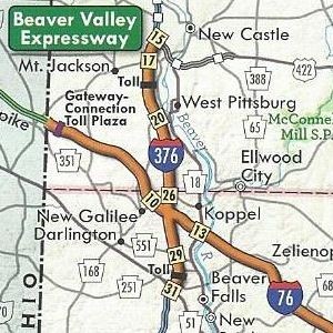
Allegheny County/Washington County PA Turnpike 576 completed between Interstate 376 and US 22
Beaver County/Lawrence County Interstate 376 replaced PA Turnpike 60
Fayette County PA Turnpike 43 completed from Exit 15 to Exit 22
Fayette County/Washington County PA Turnpike 43 under construction from US 40 to PA 88
The cover of the 2011 official Turnpike map features three postcards of various sections from the original Turnpike, with the logo of the 70th anniversary in the middle.
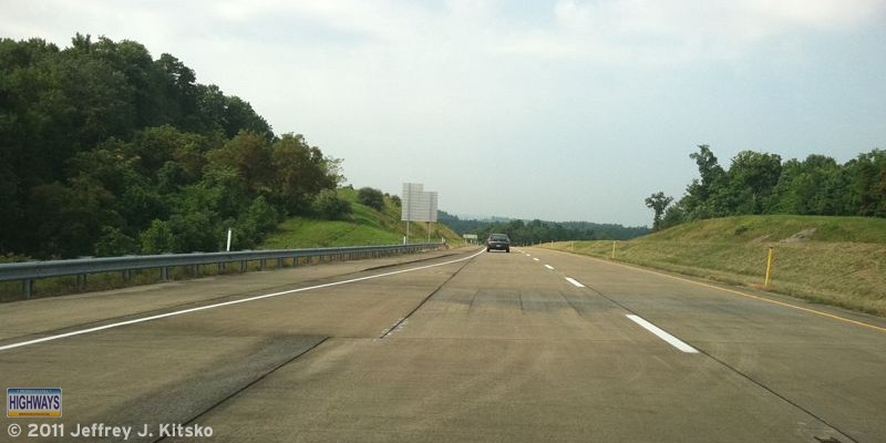
Tom Petty said the waiting is the hardest part, and the Turnpike Commission can attest to that musical proclamation. The Mason-Dixon Link, which is the section from the state line to Exit 8 of the Mon-Fayette Expressway, was built in the late 1990s. The majority of it opened on March 1, 2000, to traffic. The exception was the piece from the West Virginia state line to Exit 2. That would remain unopened for a little over a decade. The reason due to construction of WV 43 taking longer than projected because of finance issues. Ironically, that problem would be solved during the economic downturn of the latter part of the 2000s. ARRA, or economic stimulus, dollars were provided to the states for “shovel-ready” projects. Today, PA Turnpike 43 finally opens to West Virginia!
Entering PA Turnpike 43 northbound at Exit 2 in a southerly direction to reach the site of the ribbon-cutting ceremonies.
At last, the time finally came to let that “new road smell” loose and allow vehicles other than construction company ones to drive across the state line. There were two ribbon-cutting ceremonies held: one south of the Mason-Dixon Line and one north.
The West Virginia Department of Transportation was up first at 10:30 AM. They brought their starting line-up of dignitaries, including Senator Joe Manchin III and Governor Earl Ray Tomblin. Below is footage of the West Virginia ceremony.
After the cutting of the ribbon, it was time to jump into the provided shuttle buses or your personal vehicle and head back north into Pennsylvania. Our ribbon-cutting event was not as long nor as well attended by officials as West Virginia’s.
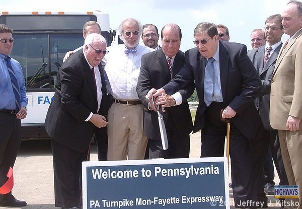
The people most responsible for the highway coming into existence are behind the sign, from left to right: PTC Commissioner J. William Lincoln, new PTC CEO William K. Lieberman, Senator Richard Kasunic, and former Senator J. Barry Stout.
The ceremonies marking the end of the 11-year wait for the Mon-Fayette Expressway’s “Mason-Dixon Link” to finally cross the Mason-Dixon Line. In short, PA Turnpike 43 finally opens to West Virginia!
Global Positioning Satellites, or GPS, has revolutionized the world. Now with the help of GPS-enabled devices, being lost is quickly becoming obsolete. Not only can people be found who were lost and possibly injured in the deepest wooded area, but drivers can find that hidden shortcut, and walkers and joggers can record their latest achievement.
One of the uses of GPS chips has been inclusion in cell phones over the past decade. Aside from being able to locate you in the event of an emergency when calling 911, it can help navigate unfamiliar territory. The advent of the smartphone has brought apps utilizing the GPS chip such as Google Maps and Foursquare.
“What is Foursquare?” you may ask. It is a social networking platform like Twitter and Facebook, but unlike those websites, Foursquare gets you away from your computer and out exploring. Users can “check in” to various locations from their cell phones, which earn them points and badges. Check in more times at one place, and you will become “Mayor” of that location which might earn you a perk.
Foursquare is about where Twitter was two years ago. It is on the cusp of being the “next big thing” in the world of Web 2.0. Just as organizations jumped on the Twitter bandwagon, they are jumping, or I should say checking in, on the Foursquare bandwagon. VisitPA (the Department of Tourism) has three badges, PA Retail Polka, PA 4 Score & 7, and PA Shooflyer, that users can earn by checking in at certain places around the Commonwealth.
Now Pennsylvania Highways has joined them, and Washington State Department of Transportation and Missouri Department of Transportation, with a Foursquare page. It will be used to give tips on highway-related check in points such as the Squirrel Hill Tunnel or one of the Turnpike interchanges, but only read them on the website or let a passenger read them to you. Perhaps a badge or two will be offered if Foursquare permits it in the future, but before you ask, there will not be a “Pothole Badge.”
It has been three years since there was a holiday edition of the longest running road enthusiast meets in southwestern Pennsylvania. That and the streak of Saturday-only meets came to an end today with the Winter 2010 SWPA Meet. I’d like to thank all who traveled both near and far to attend. They did so even with the snow falling in the area and the winter storm churning up the Eastern Seaboard.
The meet began at 12 PM at the Route 40 Classic Diner on what is now Business US 40 in Brownsville. Food was good as well as the conversations. My Maryland counterpart, Mike Pruett, brought a copy of an old trails guide book. It is a precursor to the modern road atlas, from the late 1920s, for everyone to peruse. I brought some recent Pennsylvania official maps from 2006 to 2010. Just in case anyone needed to fill gaps in their collections.
Since these holiday meets are on a smaller scale than the ones during warmer months, the tour was not too extensive. After lunch, we headed down Business US 40 into Brownsville for a taste of the old National Road and to check out the work on connecting PA Turnpike 43 to the PA 88 expressway in West Brownsville. The new alignment, which leaves PA 88, is quite evident as it swings east to cross the Monongahela River. The former intersection of old and new PA 88 has been reconfigured to be a continual route through the future interchange. This leaves up for debate whether PA 88 will be moved back to its former route into West Brownsville, or join with PA Turnpike 43 to US 40.
The cloverleaf at PA Turnpike 43 and US 40 is temporarily a partial one. This is due to ongoing construction to upgrade the segment of PA 88 that will be incorporated into the expressway. The northbound lanes are being rebuilt. What is interesting is that the overhead gantry that was before the cloverleaf has been replaced with a blue, mono-tube gantry that is seemingly becoming standard on the roadway.
Back across the Lane Bane Bridge, we picked up the old road and stopped at the Searights Toll House. Unlike the last Winter SWPA Meet, there were no broken windows nor damaged screen doors to report. It was good to see that a security system was installed, as indicated by a sign by the entrance. Here we said goodbye to half of the attendees and the rest of us continued east on US 40 to drive through the new PA Turnpike 43/US 119 stack interchange. Afterward, we took the new route back to bring the Winter 2010 SWPA Meet to an end saying our farewells, and headed to our respective destinations.