This past weekend, I stopped at the welcome center on Interstate 70 at the Maryland state line in Warfordsburg. In doing so, I picked up a copy of the 2009 official road map. Here are the changes since the 2007 editions:
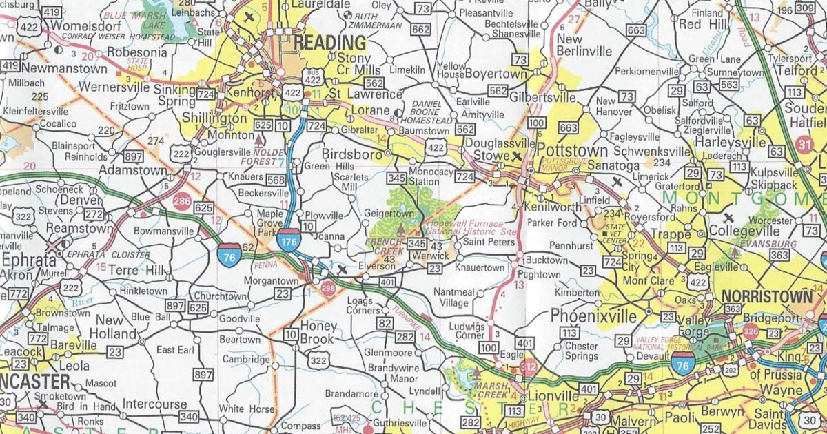
Berks County/Chester County PA 82 removed between Elverson and Birdsboro
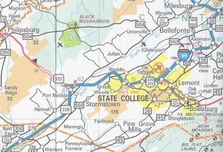
Blair County/Centre County/State College enlargement Interstate 99 completed from Bald Eagle to State College in addition to being signed from there to Interstate 80
Fayette County PA Turnpike 43 completed between Exit 15 and Exit 22 and shown under construction between Exit 22 and PA 88
Lehigh County/Allentown-Bethlehem-Easton enlargement US 222/Trexlertown Bypass completed from PA 100 to Interstate 78
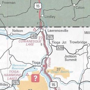
Tioga County US 15 finished from PA 287 to New York and PA 287 extended further along old US 15 to Lawrenceville
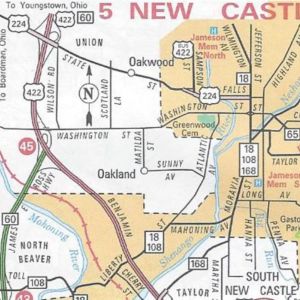
New Castle enlargement US 224 extended further than US 422/PA 60 eastward on State Street and Falls Street
In conclusion, those are all the changes to the 2009 official road map. It has the same dimensions as the previous year’s; however, this year’s cover is of an Amish buggy driving on one of the newly designated Civil War Trails. You may view the map at PennDOT’s GIS page.
If the Departments of Transportation and Tourism would have waited, they could have given a shout-out to our three professional sports teams that won championships in the past year. The North Carolina Department of Transportation did that for the Carolina Hurricanes on the cover of their 2007 map.
There is a lot of talk these days about the newest revolution on the Internet: Social Networking. It started with this blog, which I use to write not just about the roads across the Commonwealth, but musings about Pennsylvania. However, other means of social networking have come along since blogs were all the rage. I began to think how these new tools could benefit Pennsylvania Highways. So today, on the ninth anniversary of when I purchased the pahighways.com domain, I created a couple new avenues of communication, so you can social network with us by tweeting, liking, or watching Pennsylvania Highways.
Twitter The new cultural buzzword. Everyone seems to be twittering, from Oprah to Senator John McCain. I’ve seen other Twitter pages such as CNN’s and the Washington State Department of Transportation’s and thought how it could work for my site. PennDOT and the PTC do have a system where people can receive text messages; however, it doesn’t have the immediacy of a Twitter post. So using the WSDOT “template,” I created an account that will not only be used for updates to the site, but news items pertaining to the highway system.
Facebook Another phenomenon that seems to have come out of nowhere and taken the Internet by storm is Facebook. It seems that everyone from 9 to 90 has a Facebook page, even people’s pets! So I figured why not create a Pennsylvania Highways presence on this platform as well. Posts will include news articles, website updates, announcements of upcoming road enthusiast meets, and other events.
YouTube No doubt you have spent time on this site. Probably watching a clip of a skateboarding bulldog while trying not to get caught by the boss. YouTube is nothing new to the road enthusiast community, as others have been recording their journeys and uploading them to this popular website. So now Pennsylvania Highways has entered the fray. However, trying to find its niche will take a little longer than it took to set the page up.
One issue is that PennDOT has saved me the work by going ahead and videotaping all state routes. Another issue is that I need a newer video camera than my family’s circa 1991 Panasonic camcorder that is as big as a half loaf of bread, or just buy the A/V dongle from Hauppauge, so I can record the video from it onto my computer’s hard drive. Basically, this idea is still on the burner.
Today was the second meet in Happy Valley but unlike the first edition, Mother Nature gave us a rain-free day. I’d like to thank all who attended and for making the trip for the 2009 State College Meet.
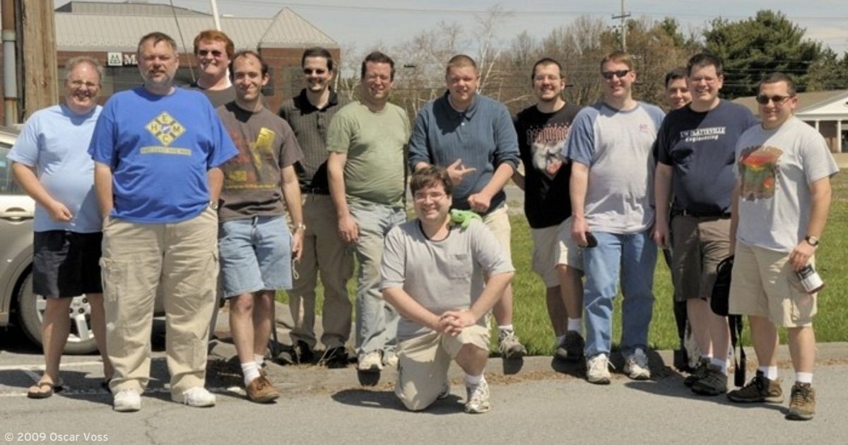
The meet began at 12 PM at Hoss’s Steak & Sea on Business US 322 (North Atherton Street). Food was good as well as the conversations. Many of the attendees brought road-related materials to peruse as well as to keep: Steve Alpert – Florida Turnpike maps; H.B. Elkins – new Kentucky and West Virginia maps; and Doug Kerr – Interstate 87 Northway maps. I brought some recent official state maps from Kentucky, Maryland, Tennessee, and of course, Pennsylvania.
Left to right: Oscar Voss, Doug Lowmaster, Mike Barron, John Krakoff, Jeff Kitsko, Doug Kerr, Brian Rawson-Ketchum, Denny Pine, Brian Powell, Scott Onson, and Adam Froehlig
After lunch, we hopped in our cars and drove down via former US 220/US 322 to PA 550. On this road is the location of the first stop on the 2005 Meet tour. It provides a good view of the completed Interstate 99. Where the two roads cross is where some of the acid rock problems had occurred. The large retaining pond, constructed on the south side of the Interstate to catch acidic run-off, contained a good amount of water.
Continuing down former US 220/US 322, now known as SR 3042, we stopped at the top of Skytop Mountain. This provides a good vantage point which overlooks the Interstate everyone loves to hate. Construction crews discovered pyritic rock in this area, which eventually stalled work on Interstate 99 until a solution was devised. The plan included removing the disturbed rock and keeping the remainder at the location. It is easy to see where the undisturbed acid rock is located. Mesh and rocks cover it to prevent erosion.
We continued on SR 3042 to SR 3040 to Port Matilda, passing through the trumpet interchange where “END” and “BEGIN” signage still exist for Alternate US 220. I would expect it to be decommissioned before the next official state map. The reason being there is no mention of the route on new signage on Interstate 80 or before the trumpet.
In the now traffic-thinned Port Matilda, we took Interstate 99 north back to State College. The view from the alignment as it climbs Skytop is fantastic and will be spectacular in Fall. We got to see in greater clarity the acid rock remediation as we headed back to the restaurant.
A few of the attendees had to leave at this point. The remainder of the group continued into State College on Business US 322. From there, we then headed north on PA 26 to the southern stub of the Bellefonte Bypass. It is now a ramp onto Interstate 99/US 220; however, there were plans to continue it south to the end of the US 322 expressway north of Lewistown.
Following northbound Interstate 99/US 220/PA 26, we turned off onto the former route of 26 right before the current interchange with Interstate 80. There is earth moving taking place for the relocation of Jacksonville Road, which is part of the plan for the future Interstate 80/Interstate 99 directional “Y.”
After which we head back to Hoss’s where we said our farewells, and headed to our respective destinations after the 2009 State College Meet.
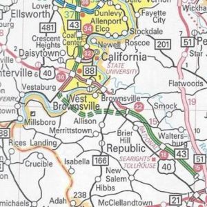
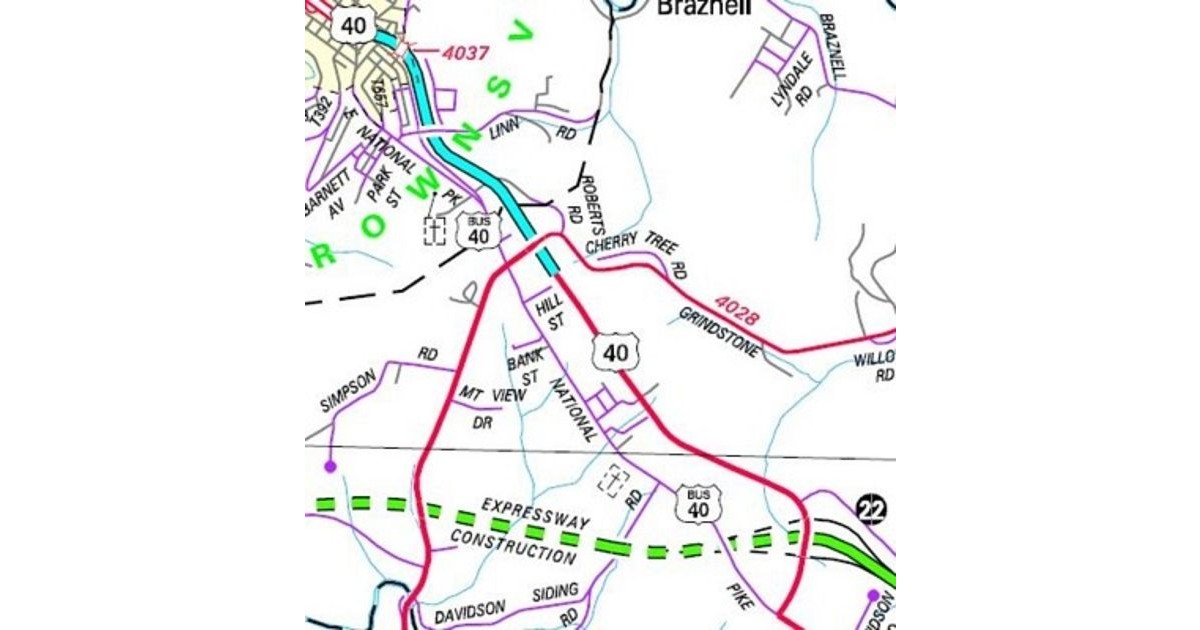
Congratulations Brownsville, you’re the proud parents of the newest auxiliary route in Pennsylvania! It is a bouncing baby business route for US 40.
With the new section of US 40 east of the borough finished, PennDOT decided to sign the former route as business route. The new designation keeps the US 40 markers on the former route from Redstone Way to PA 166. In addition, they return to the former route into Brownsville for the first time since 1970!
The numerous changes in this area are all due to the Mon-Fayette Expressway. Completing US 40 from the end of the expressway at Grindstone Road, where traffic has had to zig-zag since the Nixon administration, has always been a part of the expressway plan.
The section of US 40 expressway that exists was built in anticipation of it becoming part of the proposed route. The Turnpike Commission was considering including that piece even as it was planning the route through Fayette County. However, the PTC decided to route Turnpike 43 around Brownsville on an entirely new path.
Path of the newest US Business Route in Pennsylvania. (PennDOT)
Make sure to send all gifts and cards to PennDOT District 12-0 to congratulate them on their new bouncing baby business route.
It seems the route change many were expecting around the New Year did not pan out. I am speaking of course about the extension of Interstate 376. However, it did not mean that the official state road map lacked any changes after the opening of Interstate 99 in Centre County. Two decades of futility came to an end involving PA 82 in Berks County.
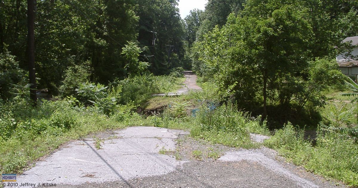
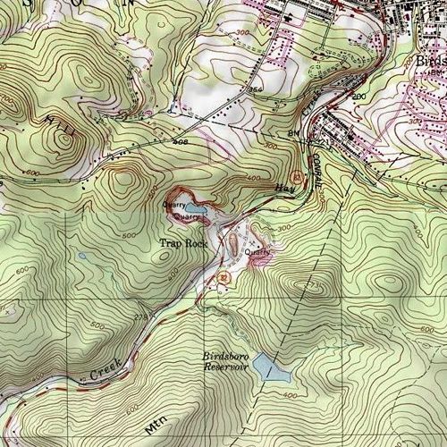
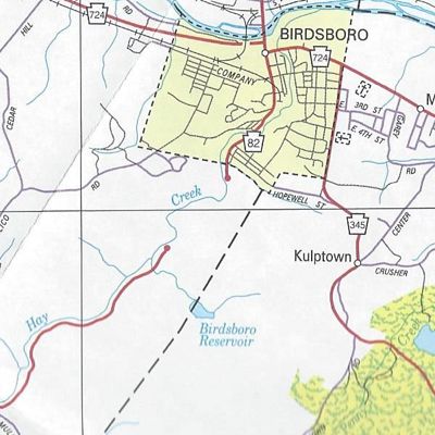
In December, PennDOT decided to truncate PA 82 at PA 23 in Elverson. The remainder of the route in Chester County became SR 4082. In Berks County, the route became SR 2082 north to Birdsboro. An extension of the PA 345 designation replaced PA 82 from Birdsboro to its former northern terminus at US 422.
The northern end of the closed section of PA 82 in Birdsboro
A tropical depression inundated eastern Pennsylvania on the night of September 8, 1987. Consequently, the flooding it caused destroyed several bridges that carried PA 82 across Hay Creek south of Birdsboro. The Department of Transportation wanted to rebuild them, but local opposition was strong from the residents who lived nearby. The local residents became accustom to the lack of traffic and wanted to keep it that way. As a result, PA 345 became the de facto detour for north-south traffic between southern Berks County and Birdsboro.
The section devastated by flooding and subsequently closed to traffic. (United States Geologic Survey)
Now, with all the changes, it may be said that two decades of futility finally reached an end.
The gap in the PA 82 alignment south of Birdsboro. (PennDOT)
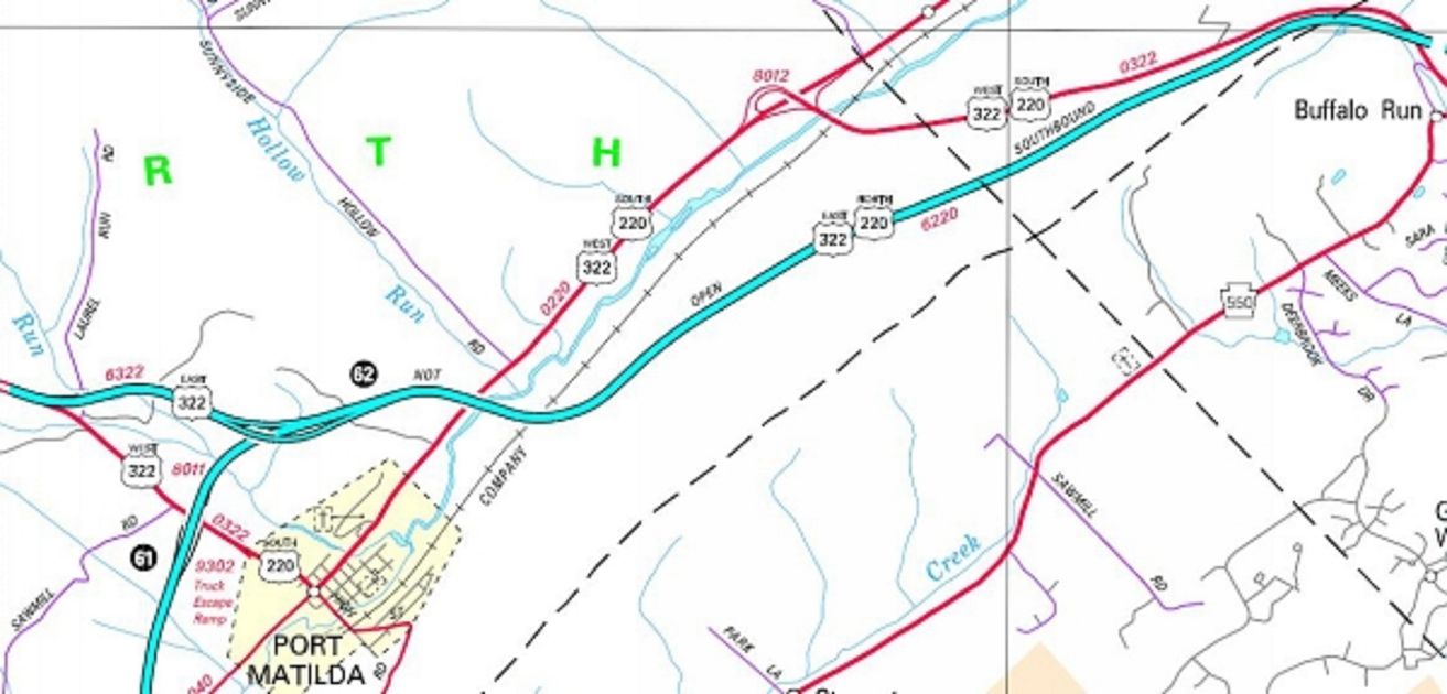
Those who live along, and those who have had to travel the narrow and dangerous US 220 through the Bald Eagle Valley, have another reason to give thanks this Thanksgiving. As of 3 PM today, the Bud Shuster Highway is finally open to both northbound and southbound traffic across Bald Eagle Mountain. In other words, Interstate 99 finally opens on Skytop!
PennDOT had previously opened both directions from Bald Eagle to Port Matilda in December 2007. However, from that point north, it was only open northbound. Continuing clean up of pyritic rock unearthed during construction was the reason. Southbound traffic was still using the old alignment. So it is now official: PennDOT has slain the acid rock dragon.
Routes of US 220 and US 322 as remediation of acid rock was winding down
Interstate 99 markers now line the new highway. However, it is only one of two Interstates to have its designation signed into law. Due to this issue, legislation will need to pass in order to update the definition of the route. As of this post, the bill still needs to pass. Therefore, it could be said it is currently illegal being designated as such. However, then again, some people would already say it is that due to being west of Interstate 81. Nonetheless, Interstate 99 finally opens across Skytop Mountain.
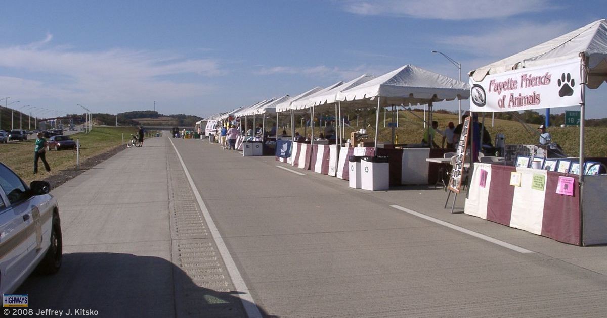
Today was the latest of the Pennsylvania Turnpike Commission’s “Community Day on the Expressway” events, and this is the third one which I have attended. However, this is the first one I went to for a section of roadway which I was also at its groundbreaking ceremony.
The festivities took place just outside of Uniontown on the newest section of the Mon-Fayette Expressway. It will open to traffic on October 23. These are nice events that the PTC holds prior to opening a new section of roadway, plus they give the public the chance to preview the new roadway.
Today’s “Community Day” took place at Exit 18. It was held in partnership with the Fayette Chamber of Commerce, Steps to a Healthier PA – Fayette County, the National Road Heritage Corridor, and construction manager TCMS-Maguire.
Steps to a Healthier PA – Fayette County sponsored a Family Fun Walk. Although it began at 9 AM, it lasted the rest of the day. The public was welcome to walk, jog, as well as bike on eight miles of the road. However, school buses provided a quicker tour if you did not want to use those options to view Turnpike 43. After that, the next part of the event was the “Modes of Transportation” parade at 10 AM.
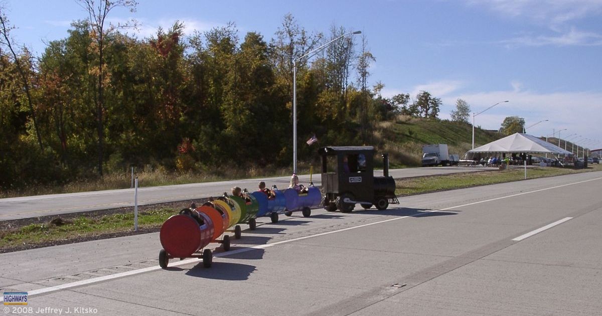
Fifteen vendors selling food and crafts lined the road. A children’s area had balloon art from Airheads Balloon Art to keep the kids busy. The Rainbow Express trackless train was available for them to ride around on the roadway nearby. In addition, there were informational booths from the Turnpike Commission and the National Road Heritage Corridor.
Food vendors, informational booths, and a children’s area were provided
The Rainbow Express trackless train was one of several activities for children
The sections I drive could be classified as horror. However, comedy is the genre of John Putch’s independent movie Route 30. The Chambersburg native filmed the movie along, what else, US 30 last October. Stars include Dana Delany of Desperate Housewives and Curtis Armstrong, best known to audiences as Herbert Viola on the 1980s TV show Moonlighting. Fellow Lincoln Highway Heritage Corridor board member Ed Gotwalt, owner of Mister Ed’s Elephant Museum, also has a part.
The movie consists of three difference stories told from three different points of view. First are the frustrations of Civil War tour guide Mandy, played by Nathalie Boltt, who obsesses over Jennie Wade. She is the only civilian killed at the Battle of Gettysburg. At the same time, her friend June, played by Christine Elise McCarthy, struggles to make extra money with an Internet porn scheme.
The second story focuses on a man, played by Kevin Rahm. He finds a Christian Scientist, played by Wil Love, to heal his back pain. He also attempts to explain the Big Foot who chased him down a mountainside.
The last story is of a writer, played by David DeLuise, who purchases a farmhouse in hopes that it will inspire him to write his novel. He ends up sidetracked by his Amish neighbor, played by Dana Delany, who smokes, drinks, swears, and watches his TV.
The premier of the movie Route 30 will be at the Majestic Theatre in Gettysburg on September 27, 2008, at 8 PM. A Q&A session with the cast and crew will follow. Tickets to the screening are $16 per person. A portion of the proceeds benefit the Lincoln Highway Heritage Corridor and Totem Pole Playhouse non-profit organizations. You can purchase tickets at the Totem Pole Playhouse, Mister Ed’s Elephant Museum, Majestic Theatre, or at the movie’s website.
Saturday was the latest edition of the longest running road enthusiast meets. I’d like to thank all who traveled both near and far to attend the Winter 2007 SWPA Meet.
The meet began at 12 PM at Garfield’s in the Uniontown Mall on US 40 near the US 119 interchange. The food and conversation was excellent as always. I provided each attendee with a copy of the 2007 PennDOT map.
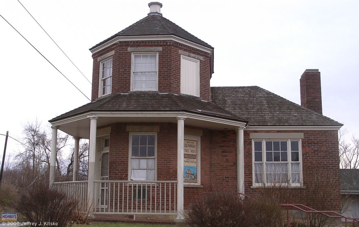
After the lunch portion, we headed down US 40 to see the new Brownsville Connector. We decided to make the Searights Toll House the first stop, and it’s best that we did. I noticed that one of the windows appeared to be open. Upon further examination, it wasn’t open. Rather, someone had taken one of the bricks from the steps and smashed the window. In addition, there were rips and pulls in several places in the screen on the screen door at the entrance. After calling 911, they informed me that the police would investigate and the proprietors would be notified.
Searights Toll House
The next stop was to see the new US 40 connector that just opened east of Brownsville. What struck the attendees of the 2006 gathering was the former partially constructed interchange just north of PA 166, where US 40 traffic would turn to continue, has been replaced with an at-grade intersection. Even though last year, we noticed grading for what appeared to be the other entrance/exit ramps had taken place, which is noted on the US 40 page. Also, PA 166’s northern terminus has not moved to intersect the new US 40 alignment. The route still ends at the former intersection, a block to the south. Grading at the future PA Turnpike 43 interchange, which is currently a temporary end until the loop around Brownsville opens, is complete.
On the way back to Uniontown, we took a small detour over a new connector road built between PA 51 and US 40. It will serve an interchange of PA Turnpike 43 and is five lanes wide (four travel lanes and a center turn lane). This roadway is located through the area where I attended the groundbreaking for the Uniontown/Brownsville section.
We took PA 43/PA Turnpike 43 south and stopped at the current end at Gans Road. Afterwards, we continued south into West Virginia to see how they are progressing on their section. From PA 857/WV Secondary 857, it is possible to see the bridge on the state line is complete. It includes a “Welcome to West Virginia” sign gantry. Turning off onto Morgan’s Run Road, we had an up-close look at another pair of spans taking shape and saw a completed section of WV 43 with signage already installed. Back at 857 we continued south to the Cheat Lake interchange. There we saw the construction taking place in preparation of the directional “T” interchange between Interstate 68 and WV 43.
After turning around, we headed back to Garfield’s. There we said our goodbyes, Merry Christmases, Happy New Years, and headed to our respective destinations after the Winter 2007 SWPA Meet.
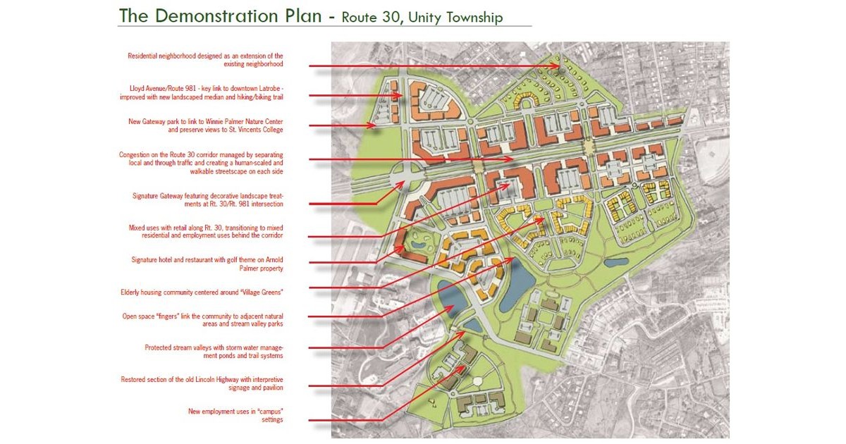
One of the things that we’re not that good about in Pennsylvania is planning for the future. Tonight, myself and others in my area decided to do something about that. Smart Growth Partnership of Westmoreland County has been holding a public Charrette this week at the University of Pittsburgh at Greensburg.
The imagined US 30 corridor south of Latrobe
We were placed in groups and asked to evaluate different plans for the area of US 30 in Unity Township outside Latrobe. The first plan would create almost another town along 30 from PA 981 to PA 982. No one liked this one because the minimum building height would be six stories. Obviously this would destroy the views of the Laurel Ridge and trying to keep the area rural. The second plan would be to keep more of the area in a rural setting, but enhance the existing developments along the corridor. The third plan would be a “Greenway” solution, where most of the businesses would be removed and more of the area returned to a natural state.
While most seemed to prefer the latter, I was in favor of the second plan. The first plan and last plan would eliminate the shopping areas of Latrobe 30 Plaza, Mountain Laurel Plaza, Wildcat Commons, and Unity Plaza. Stores such as Giant Eagle and Wal*Mart would go away. I highly doubt Wal*Mart will have gone the way of Montgomery Ward by the year 2020. Although people probably said the same about Wards in 1980 so who knows.
Planning for the future traffic growth, I proposed the idea of completely bypassing current US 30 with an expressway. This would remove the through traffic from the highway and create a Business US 30 on the current alignment. Actually, not my idea, but the “Route 30 Relocation” proposal from the Pittsburgh Area Transportation Plan devised in the 1960s. The same thing happened between Sadsburyville and Exton. The current alignment of 30 is an expressway and the original alignment is a business route. Then a redesign could take place of any area along the corridor without having to contend with as much traffic. However, my idea did not garner any approval. Oh well, so much for trying to undo past mistakes.