One of the things I like about working on this website is showing and explaining how the highway system of Pennsylvania has evolved over the years. Now I am taking the show on the road…literally.
So on March 11, I am taking this website and crunching it down to an hour-long presentation entitled Pennsylvania’s Roadways: From the Lincoln to Eisenhower. It will be Sunday, March 11 beginning at 2 PM at the Lincoln Highway Experience, the headquarters for the Lincoln Highway Heritage Corridor, at 3435 Route 30 East (a.k.a. the Lincoln Highway) in Latrobe. Refreshments will be provided.
Due to limited seating in the auditorium, advanced reservations are required, which can be made through the LHHC’s website or by calling 724-879-4241. Admission is $10/person for non-LHHC members and $7/person for Friends of the Lincoln Highway.
Today I received an order from PennDOT which included a copy of the 2011 official road map. It is not surprising PennDOT went to the trouble of printing one, since we elected a new Governor last year and therefore have a new Secretary of Transportation. These are the changes since the 2010 edition:
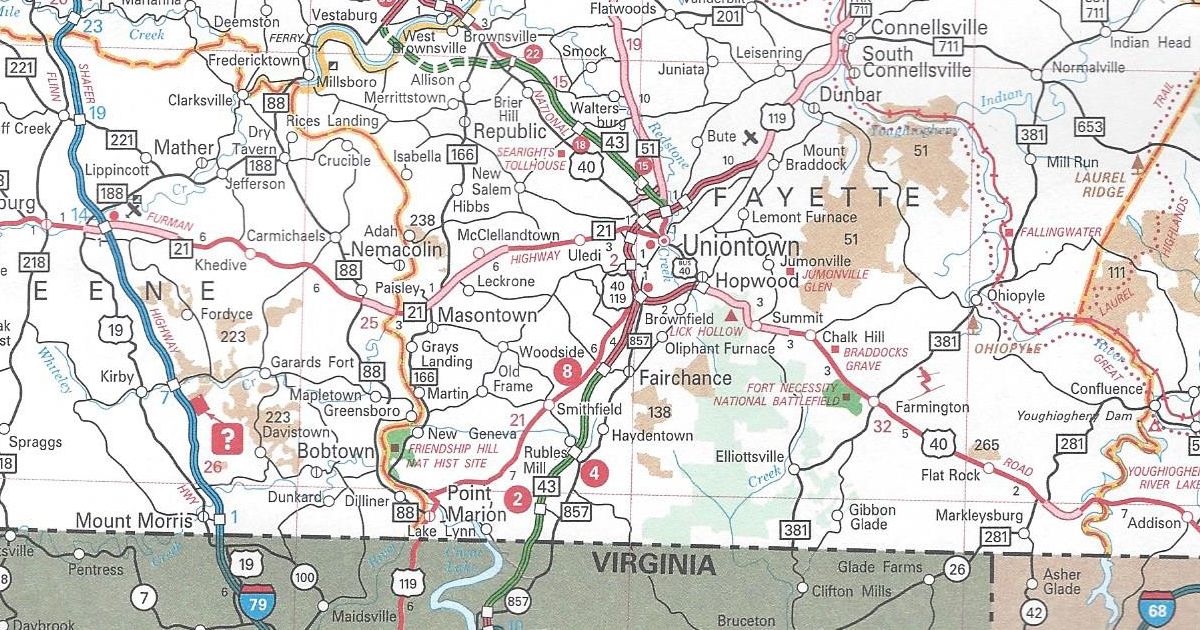
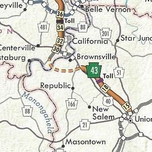
Fayette County PA Turnpike 43 completed from West Virginia to Exit 2 and the US 119/PA 51 interchange to Exit 15
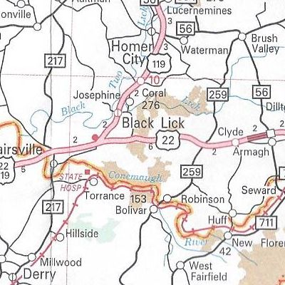
Indiana County US 22 is now a four-lane, divided highway from just east of Blairsville to Armagh
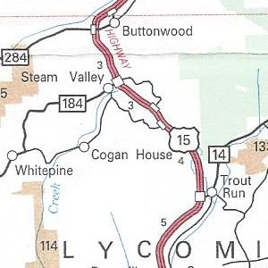
Lycoming County US 15 upgraded to an expressway from north of PA 14 to PA 184
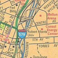
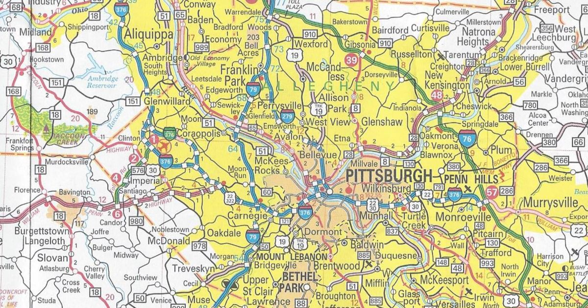
Pittsburgh enlargement Consol Energy Center shown
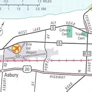
Erie enlargement PA 299 removed from Powell Avenue
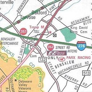
Philadelphia enlargement Street Road E-ZPass-only slip ramp completed
Those are all the changes to the 2011 official road map. For most of the URLs on the map, there is a likewise corresponding Microsoft Tag to scan with a smartphone. However, the link for VisitPA uses a regular QR Code.
No longer appearing on the map is the yellow shading of “Selected Built Up Areas.” Meanwhile, the dark, shaded areas of urban concentrations remain. State Game Lands have changed from a peach coloring to a tan one. The State Park textured color used to indicate the extent of said park has been removed, but it remains in the city insets.
Above all, the US 22/US 322 shield error on the 2010 map on the Penn-Lincoln Parkway at PA 60 is now the correct US 22/US 30 shield. There is now an inset for the Elk Scenic Drive in the upper left corner over Lake Erie. A yellow highlight instead of an orange one indicates its path on the main map.
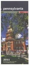
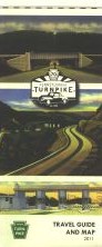
It has the same dimensions as the previous year’s map. However, this year’s cover features a picture of Independence Hall.
Today, the ribbon-cutting event for the latest section of Mon-Fayette Expressway occurred. Not only did I pick up several free bottles of water compliments of the Turnpike Commission, I picked up something I haven’t seen in years: a new 2011 official Turnpike map.
The PTC’s “belt-tightening” in recent years led to them not printing a map. It is evident by looking at this one, as it is much smaller than its 2004 ancestor. The reason for this change is in a note below the legend:
To conserve natural and fiscal resources, our Travel Guide and Map is half the size of earlier editions. The new size also responds to a shift in how travelers — in an age of online maps and GPS devices — use printed maps today.
In addition, the map is not a PennDOT official. The Turnpike System is not highlighted in green, with a white-on-green Keystone shield denoting the route number. That was the standard since the 1980s. It appears with these two changes that the Turnpike map is returning to its ones from the 1960s and 1970s, which were printed by Rand McNally and General Drafting.
The main map of Pennsylvania features images of postcards of the Turnpike at the top of the map. A mention of the 70 years of the Turnpike is in the corner, the milestone celebrated the year before. One change I like is that the background of the border states are not pink or purple as they were on the 2004 map.
The back side of the map still includes information on E-ZPass and commercial trucking regulations. There is toll information but just like the first run of tickets this year, there is no fare schedule. There are strip maps for the system. However, the insets of cities which the Turnpike passes through are no longer. The following are changes since the 2004 edition:
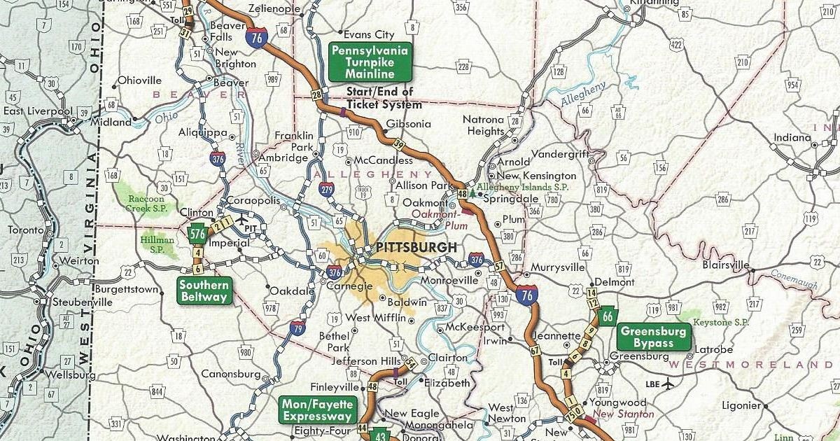
Allegheny County/Washington County PA Turnpike 576 completed between Interstate 376 and US 22
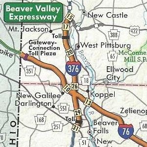
Beaver County/Lawrence County Interstate 376 replaced PA Turnpike 60
Fayette County PA Turnpike 43 completed from Exit 15 to Exit 22
Fayette County/Washington County PA Turnpike 43 under construction from US 40 to PA 88
The cover of the 2011 official Turnpike map features three postcards of various sections from the original Turnpike, with the logo of the 70th anniversary in the middle.
Global Positioning Satellites, or GPS, has revolutionized the world. Now with the help of GPS-enabled devices, being lost is quickly becoming obsolete. Not only can people be found who were lost and possibly injured in the deepest wooded area, but drivers can find that hidden shortcut, and walkers and joggers can record their latest achievement.
One of the uses of GPS chips has been inclusion in cell phones over the past decade. Aside from being able to locate you in the event of an emergency when calling 911, it can help navigate unfamiliar territory. The advent of the smartphone has brought apps utilizing the GPS chip such as Google Maps and Foursquare.
“What is Foursquare?” you may ask. It is a social networking platform like Twitter and Facebook, but unlike those websites, Foursquare gets you away from your computer and out exploring. Users can “check in” to various locations from their cell phones, which earn them points and badges. Check in more times at one place, and you will become “Mayor” of that location which might earn you a perk.
Foursquare is about where Twitter was two years ago. It is on the cusp of being the “next big thing” in the world of Web 2.0. Just as organizations jumped on the Twitter bandwagon, they are jumping, or I should say checking in, on the Foursquare bandwagon. VisitPA (the Department of Tourism) has three badges, PA Retail Polka, PA 4 Score & 7, and PA Shooflyer, that users can earn by checking in at certain places around the Commonwealth.
Now Pennsylvania Highways has joined them, and Washington State Department of Transportation and Missouri Department of Transportation, with a Foursquare page. It will be used to give tips on highway-related check in points such as the Squirrel Hill Tunnel or one of the Turnpike interchanges, but only read them on the website or let a passenger read them to you. Perhaps a badge or two will be offered if Foursquare permits it in the future, but before you ask, there will not be a “Pothole Badge.”
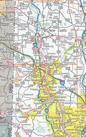
Today, I stopped at the welcome center on Interstate 70 at the Maryland state line in Warfordsburg and picked up a copy of the 2010 official road map. I am surprised PennDOT even bothered to print one this late in the year that isn’t a “B” version, especially since there will be a new governor come Tuesday. These are the changes since the 2009 edition, all of which involve the extension of Interstate 376:
Allegheny County/Pittsburgh enlargement Interstate 376 extended west beyond I-279 to multiplex with US 22/US 30 and replace PA 60 Interstate Business Loop 376 replaced Business PA 60
Beaver County/Lawrence County/New Castle enlargement Interstate 376 replaced PA 60 and PA Turnpike 60
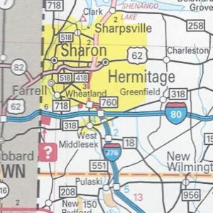
Mercer County Interstate 376 replaced PA 60 PA 760 replaced PA 60 from I-80 to Sharon
Those are all the changes to the 2010 official road map. In addition, there are two mentions of the new 511 system: one on the back cover under the list of welcome centers and another at the top next to the legend.
Rarely do I find an error on the official maps, but this year there is a blatant one near the junction of the Penn-Lincoln Parkway and PA 60 west of Pittsburgh. A US 22/US 322 shield is located where there should be, and last year was, a US 22/US 30 shield.
It has the same dimensions as the previous year’s. However, this year’s cover features a view of Johnstown from the Inclined Plane station above the city in Westmont.
This past weekend, I stopped at the welcome center on Interstate 70 at the Maryland state line in Warfordsburg. In doing so, I picked up a copy of the 2009 official road map. Here are the changes since the 2007 editions:
Berks County/Chester County PA 82 removed between Elverson and Birdsboro
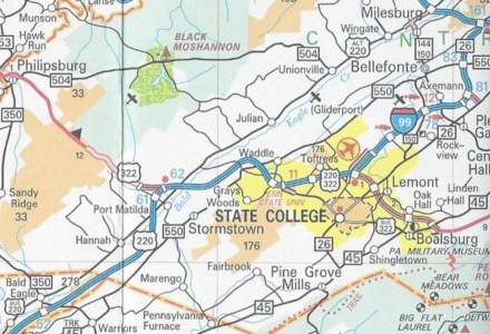
Blair County/Centre County/State College enlargement Interstate 99 completed from Bald Eagle to State College in addition to being signed from there to Interstate 80
Fayette County PA Turnpike 43 completed between Exit 15 and Exit 22 and shown under construction between Exit 22 and PA 88
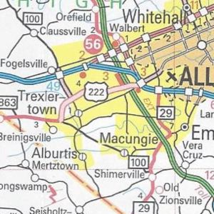
Lehigh County/Allentown-Bethlehem-Easton enlargement US 222/Trexlertown Bypass completed from PA 100 to Interstate 78
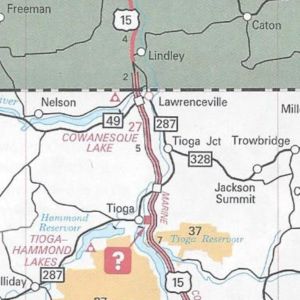
Tioga County US 15 finished from PA 287 to New York and PA 287 extended further along old US 15 to Lawrenceville
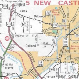
New Castle enlargement US 224 extended further than US 422/PA 60 eastward on State Street and Falls Street
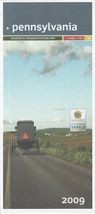
In conclusion, those are all the changes to the 2009 official road map. It has the same dimensions as the previous year’s; however, this year’s cover is of an Amish buggy driving on one of the newly designated Civil War Trails. You may view the map at PennDOT’s GIS page.
If the Departments of Transportation and Tourism would have waited, they could have given a shout-out to our three professional sports teams that won championships in the past year. The North Carolina Department of Transportation did that for the Carolina Hurricanes on the cover of their 2007 map.
There is a lot of talk these days about the newest revolution on the Internet: Social Networking. It started with this blog, which I use to write not just about the roads across the Commonwealth, but musings about Pennsylvania. However, other means of social networking have come along since blogs were all the rage. I began to think how these new tools could benefit Pennsylvania Highways. So today, on the ninth anniversary of when I purchased the pahighways.com domain, I created a couple new avenues of communication, so you can social network with us by tweeting, liking, or watching Pennsylvania Highways.
Twitter The new cultural buzzword. Everyone seems to be twittering, from Oprah to Senator John McCain. I’ve seen other Twitter pages such as CNN’s and the Washington State Department of Transportation’s and thought how it could work for my site. PennDOT and the PTC do have a system where people can receive text messages; however, it doesn’t have the immediacy of a Twitter post. So using the WSDOT “template,” I created an account that will not only be used for updates to the site, but news items pertaining to the highway system.
Facebook Another phenomenon that seems to have come out of nowhere and taken the Internet by storm is Facebook. It seems that everyone from 9 to 90 has a Facebook page, even people’s pets! So I figured why not create a Pennsylvania Highways presence on this platform as well. Posts will include news articles, website updates, announcements of upcoming road enthusiast meets, and other events.
YouTube No doubt you have spent time on this site. Probably watching a clip of a skateboarding bulldog while trying not to get caught by the boss. YouTube is nothing new to the road enthusiast community, as others have been recording their journeys and uploading them to this popular website. So now Pennsylvania Highways has entered the fray. However, trying to find its niche will take a little longer than it took to set the page up.
One issue is that PennDOT has saved me the work by going ahead and videotaping all state routes. Another issue is that I need a newer video camera than my family’s circa 1991 Panasonic camcorder that is as big as a half loaf of bread, or just buy the A/V dongle from Hauppauge, so I can record the video from it onto my computer’s hard drive. Basically, this idea is still on the burner.
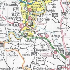
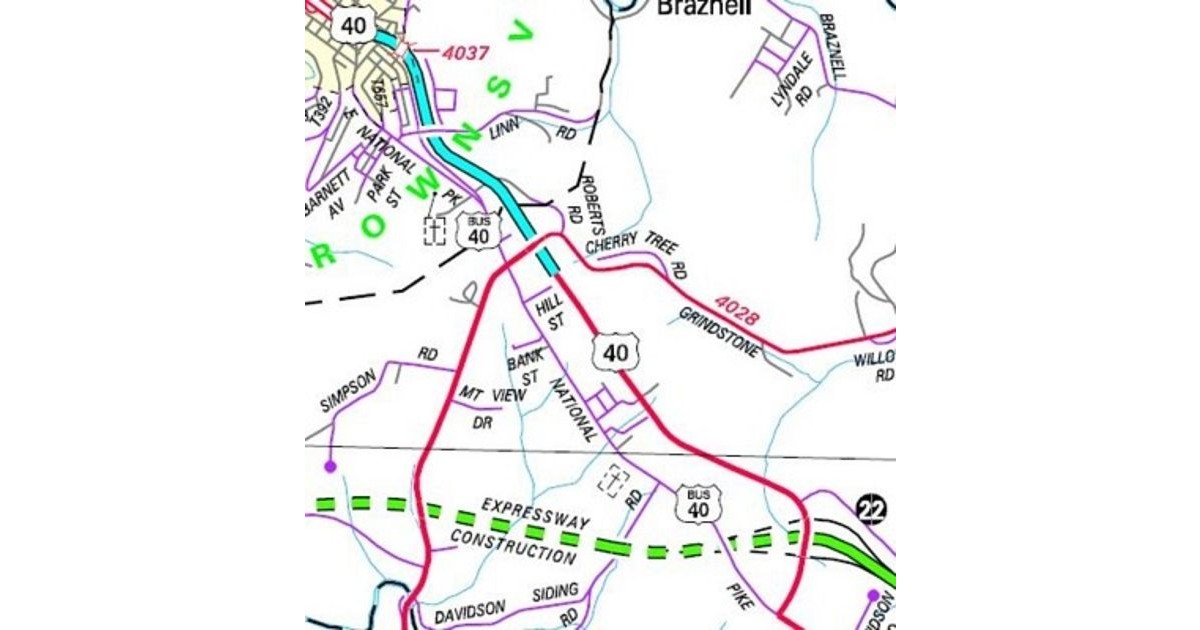
Congratulations Brownsville, you’re the proud parents of the newest auxiliary route in Pennsylvania! It is a bouncing baby business route for US 40.
With the new section of US 40 east of the borough finished, PennDOT decided to sign the former route as business route. The new designation keeps the US 40 markers on the former route from Redstone Way to PA 166. In addition, they return to the former route into Brownsville for the first time since 1970!
The numerous changes in this area are all due to the Mon-Fayette Expressway. Completing US 40 from the end of the expressway at Grindstone Road, where traffic has had to zig-zag since the Nixon administration, has always been a part of the expressway plan.
The section of US 40 expressway that exists was built in anticipation of it becoming part of the proposed route. The Turnpike Commission was considering including that piece even as it was planning the route through Fayette County. However, the PTC decided to route Turnpike 43 around Brownsville on an entirely new path.
Path of the newest US Business Route in Pennsylvania. (PennDOT)
Make sure to send all gifts and cards to PennDOT District 12-0 to congratulate them on their new bouncing baby business route.
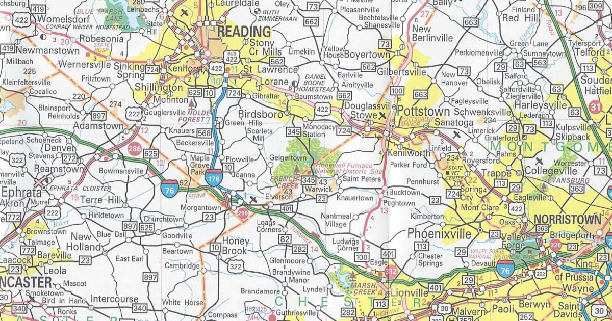
It seems the route change many were expecting around the New Year did not pan out. I am speaking of course about the extension of Interstate 376. However, it did not mean that the official state road map lacked any changes after the opening of Interstate 99 in Centre County. Two decades of futility came to an end involving PA 82 in Berks County.
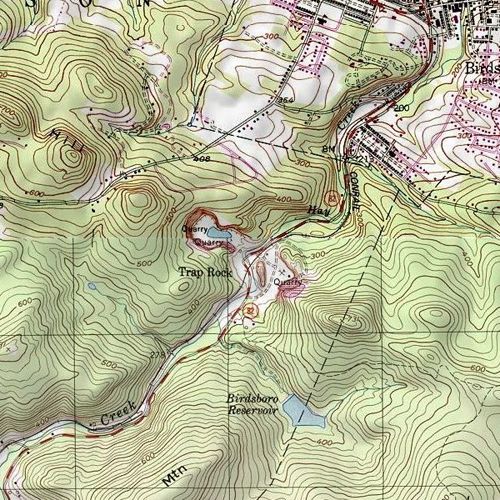
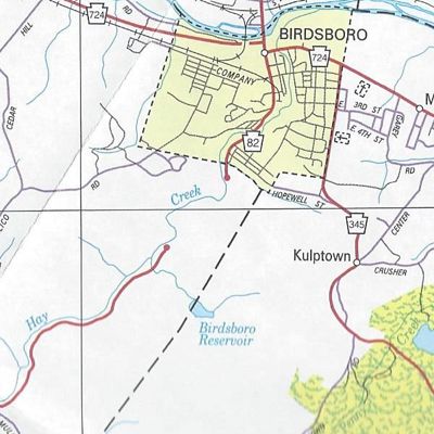
In December, PennDOT decided to truncate PA 82 at PA 23 in Elverson. The remainder of the route in Chester County became SR 4082. In Berks County, the route became SR 2082 north to Birdsboro. An extension of the PA 345 designation replaced PA 82 from Birdsboro to its former northern terminus at US 422.
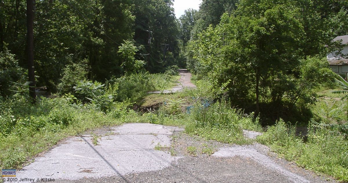
The northern end of the closed section of PA 82 in Birdsboro
A tropical depression inundated eastern Pennsylvania on the night of September 8, 1987. Consequently, the flooding it caused destroyed several bridges that carried PA 82 across Hay Creek south of Birdsboro. The Department of Transportation wanted to rebuild them, but local opposition was strong from the residents who lived nearby. The local residents became accustom to the lack of traffic and wanted to keep it that way. As a result, PA 345 became the de facto detour for north-south traffic between southern Berks County and Birdsboro.
The section devastated by flooding and subsequently closed to traffic. (United States Geologic Survey)
Now, with all the changes, it may be said that two decades of futility finally reached an end.
The gap in the PA 82 alignment south of Birdsboro. (PennDOT)
Those who live along, and those who have had to travel the narrow and dangerous US 220 through the Bald Eagle Valley, have another reason to give thanks this Thanksgiving. As of 3 PM today, the Bud Shuster Highway is finally open to both northbound and southbound traffic across Bald Eagle Mountain. In other words, Interstate 99 finally opens on Skytop!
PennDOT had previously opened both directions from Bald Eagle to Port Matilda in December 2007. However, from that point north, it was only open northbound. Continuing clean up of pyritic rock unearthed during construction was the reason. Southbound traffic was still using the old alignment. So it is now official: PennDOT has slain the acid rock dragon.
Routes of US 220 and US 322 as remediation of acid rock was winding down
Interstate 99 markers now line the new highway. However, it is only one of two Interstates to have its designation signed into law. Due to this issue, legislation will need to pass in order to update the definition of the route. As of this post, the bill still needs to pass. Therefore, it could be said it is currently illegal being designated as such. However, then again, some people would already say it is that due to being west of Interstate 81. Nonetheless, Interstate 99 finally opens across Skytop Mountain.